Mamores Ridge - Stob Ban, Am Bodach and Sgurr an Iubhair
Highland Walk
County/Area - Highland - Fort William Lochaber
Author - John Turner
Length - 9.0 miles / 14.6 km Ascent - 4700 feet / 1424 metres
Time - 9 hours 10 minutes Grade - hard
Maps 

| Ordnance Survey Explorer 392 | Sheet Map | 1:25k | BUY |
| Anquet OS Explorer 392 | Digital Map | 1:25k | BUY |
| Ordnance Survey Landranger 41 | Sheet Map | 1:50k | BUY |
| Anquet OS Landranger 41 | Digital Map | 1:50k | BUY |
Walk Route Description
Click image to visit gallery of 6 images.
After a superb Scottish breakfast, we scraped the cars windows of ice before setting off to the start of our walk. The freezing fog that was clamped over Fort William was not widespread, and by the time we were travelling down Glen Nevis it had cleared to blue skies and the promise of a sunny day. Using the parking area at grid ref. NN145683 we donned boots and rucksacks while admiring the pristine views. The car-park has a 'donation' machine that was out of order so we made mental note to put some money into the Mountain Rescue box at the pub that night.
Leave the car-park via the kissing gate out onto the road leading towards the bridge over the falls. Before you get to the bridge however, you will see a farmer's gate and stile to your right and over this is the path following the stream up Coire a' Mhusgain. The crisp frozen underfoot conditions made for good walking and our breath was clearly visible, although the day was bright, the sun had not yet reached over the distant ridge where we were headed.
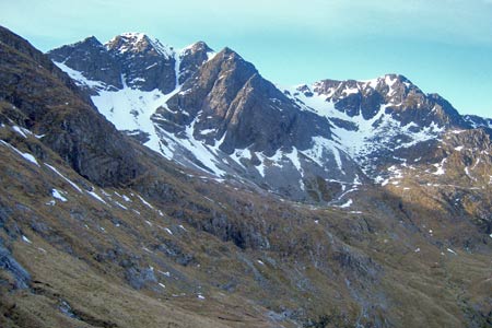
The path was obvious enough, and we settled into our own comfortable pace, with the faster walker occasionally sitting to admire the views allowing the group to stay together. As we gained height up the coire, we were sandwiched between the imposing northerly ridge between Stob Ban and Sron Dearg to our right - with the impressive Devils Ridge to our left. As we ascended further, we started to encounter large patches of snow. We had some fun crossing these as the cold and as yet sunless day ensured the snow was as hard packed as ice. Eventually we were able to walk around and avoid the patches.
Arriving at the bealach of the ridge between Sgurr an lubhair and Stob Ban (grid ref. NN159653), we were now blessed with extensive views to the south and bathed in beautiful sunshine. The effort of the final uphill stages combined with the heat of the sun ensured items of clothing were quickly discarded to our packs. After a brief drinks and snack stop, and the inevitable photo session, we started our way westerly to gain the slopes up to Stob Ban. The final push seemed relentless, but the approach to the summit opened up new vista's that caused more out of breath ooh's and aagh's. Fabulous views in all directions and the clear blue winter conditions gave crystal clear unlimited views of white topped mountain ranges out to the horizon. We reversed the route back down to the bealach and continued along the ridge to ascend Sgurr an lubhair, a short walk NW from the cairned summit gave us stunning views along The Devils Ridge to Sgurr a' Mhaim. Leaving the summit of Sgurr an lubhair, we descended the deceptively steep section of ridge before again ascending up towards the summit of Am Bodach. Apparently it's gaelic translation means 'Old Man' but it was me that felt like an old man at the top.
The descent was a straightforward affair, returning via the flanks but not the summit of Sgurr an lubhair. Descending again to the bealach and dropping back down into the shade of Coire a' Mhusgain, temperature immediately fell by a few degrees so it was fleeces on again. The route is now a reversal of the ascent and allowed the distant peaks of Knoydart and beyond to be studied. Something was attracting our attention on the opposite side of the valley. Across Glen Nevis to the west of Ben Nevis's summit area, we watched a mountain rescue helicopter performing what looked like tricky manoeuvres. Something was certainly going on as it was up there for quite a long time.
Arriving again at the lower reaches of the walk, it was evident that the sun had not kissed anything down this side. The ground, grass and vegetation was still white and frosted. We finished the walk at the car-park and although leg muscles might have been glad the walk was over, we took a final look up the Coire to where we had been and reflected on the sights and views we had seen.
That night after dinner, we went out for a few 're-hydration' drinks in a few of the local pubs. Our first call was the Nevisport Bar, where we dutifully donated generously to the local mountain rescue box. Oh and as an afterthought - the helicopter had earlier participated in two separate but nearly simultaneous climbing accidents on Tower Ridge. One guy with head injuries and another with broken pelvis.
Other walks nearby
| Walk 1338 | Ben Nevis Tourist Path | mod/hard | 8.7 miles |
| Walk 3270 | Ben Nevis | mod/hard | 9.7 miles |
| Walk 2105 | Ben Nevis via Carn Mor Dearg arete | hard | 10.5 miles |
| Walk 3106 | Binnein Mor from Kinlochleven | hard | 10.2 miles |
| Walk 1039 | Am Bodach and Stob Coire a' Chairn | mod/hard | 9.5 miles |
| Walk 1094 | Blackwater Reservoir | moderate | 11.5 miles |
| Walk 1496 | WHW - Day 6 - Kinlocheven to Fort William | moderate | 15.0 miles |
| Walk 3066 | Carn Mor Dearg (via Allt a' Mhuilinn trail) | mod/hard | 8.7 miles |
| Walk 2918 | Aonach Mor and Aonach Beag - two of the "Lochaber giants" | mod/hard | 9.0 miles |
| Walk 1162 | Pap of Glencoe | moderate | 4.2 miles |
Recommended Books & eBooks
Walking in Torridon
 This guidebook contains 52 day walks in Torridon, a remote and much-loved area of the Scottish Highlands. Based around Shieldaig and Slioch, the routes are split into 3 sections: easy walks, long and high level walks and mountain ascents over 2000ft including 9 Munros, and 5 outline suggestions for major ridge walks.
More information
Skye's Cuillin Ridge Traverse
 This 2-volume set provides all the information required to complete the main ridge traverse on Skye's Black Cuillin. Strategy, gear, training, navigation and logistics are covered, and 10 classic scrambles are described. A lightweight second guidebook gives the scrambler detailed maps, topos and route description for the ridge traverse itself.
More information
Messaging & Social Media
Message Walking Britain and follow the latest news.

Mountain Weather
Stay safe on the mountains with detailed weather forecasts - for iOS devices or for Android devices.