Nab Head & Musselwick Sands from Marloes
Pembrokeshire Coast Walk
Nat Park - Pembrokeshire Coast
County/Area - Pembrokeshire
Author - Lou Johnson
Length - 6.2 miles / 10.1 km Ascent - 700 feet / 212 metres
Time - 3 hours 50 minutes Grade - easy/mod
Walk Route Description
Click image to see photo description.
This undemanding Pembrokeshire walk explores the countryside and coast lying northwest of Marloes. The route crosses a pleasant rural landscape to reach the coast at St Brides Haven where the Pembrokeshire Coast Path is joined to head south along a very pleasant clifftop path to Musselwick Sands. The walk turns inland to visit Marloes Beacon before returning to the start.
The start is the National Trust car park close to Marloes Mere (grid ref. SM779082). After parking exit the car park onto the lane. Continue along the lane to reach Marloes Court Farm on your right. Just past the farm turn left through a gate into a field. The path follows the hedge which will be on your right. Continue to reach a gate and stile at a road (grid ref. SM789086). Turn right along the road into Marloes village. After 150 metres turn left along a side road. Almost immediately turn right onto a track (North Lane). Follow the road around to the left to pass a house on your left. Where the track bends to the right, continue ahead on a footpath along the left-hand edge of a field.
Maintain direction through another field. In the next field bear left through a hedge to join a clear track (grid ref. SM796094). Follow the track north to a T-junction. Turn right and follow the track to reach a lane. Just before reaching the lane, turn left onto a signed footpath through a kissing gate. Follow the grassy path with woodland to your right for 800 metres to reach a cross track (grid ref. SM801106). Go straight ahead along the edge of woodland to pass through the churchyard of St Bridget's Church into a parking area. Note there are public toilets a short distance to the right.
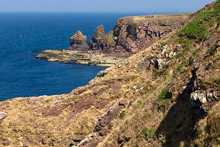
From the church entrance gate turn left and walk the short distance to the sea at St Brides Haven (grid ref. SM801109) where you bear left to join the Pembrokeshire Coast Path (also the Wales Coast Path) with sea on your right. The onward path is easy to follow and you can enjoy excellent views across St Brides Bay. The path is never demanding and as you pass The Nab Head on your right, Wooltack Point and Skomer Island comes into view ahead.
The path skirts several rocky inlets as you make good progress south. After passing above the first section of Musselwick Sands the path swings left into a small valley to reach a footpath junction (grid ref. SM786089). Leave the coast path here and go straight ahead. Follow this path reach a gate and a lane. Turn right along the lane and enjoy the view to your right. After 150 metres look out for a finger post on the left adjacent to a metal gate. You can make a short detour to the trig point on Marloes Beacon and enjoy the view across the peninsula. Return to the road, turn left, and continue for a kilometre. Turn left down a wide track just before the white house. The start of the walk is short way down this track.
Maps 

| Ordnance Survey Explorer OL36 | Sheet Map | 1:25k | BUY |
| Anquet OS Explorer OL36 | Digital Map | 1:25k | BUY |
| Ordnance Survey Digital Map Subscription | |||
| Latest Ordnance Survey Discounts | |||
Other walks nearby
| Walk 3496 | St Anne's Head & Dale Peninsula | easy/mod | 7.0 miles |
| Walk 3497 | Angle Peninsula | easy | 3.7 miles |
| Walk 2485 | Broad Haven & Druidston Circular | easy/mod | 4.9 miles |
| Walk 3498 | Freshwater West & Angle | moderate | 8.7 miles |
| Walk 1210 | Porth Clais & St Justinian's | easy/mod | 5.5 miles |
| Walk 2056 | Pointz Castle from Solva | easy/mod | 5.5 miles |
| Walk 1997 | St. David's & Coast Path Circular | moderate | 9.7 miles |
| Walk 2057 | St. David's Head & Carn Llidi | easy/mod | 4.5 miles |
| Walk 3483 | Penberry & St Davids Head from Whitesands Bay | moderate | 9.0 miles |
| Walk 3476 | Porthgain & Blue Lagoon from Abereiddy | easy/mod | 6.5 miles |
Recommended Books & eBooks
The Wales Coast Path
 A single guidebook to walking the whole Wales Coast Path - 1400km (870 miles) the length of Wales from Chester to Chepstow, including Anglesey, described in 57 stages. The route passes through the Snowdonia and Pembrokeshire National Parks and many AONBs and can be linked with the Offa's Dyke Path for a complete circuit of Wales.
More information
