Silbury Hill and West Kennett Long Barrow from Avebury
North Wessex Downs Walk
Region - North Wessex Downs
County/Area - Wiltshire
Author - Lou Johnson
Length - 3.0 miles / 4.9 km Ascent - 100 feet / 30 metres
Time - 1 hours 40 minutes Grade - easy
Maps 

| Ordnance Survey Explorer 157 | Sheet Map | 1:25k | BUY |
| Anquet OS Explorer 157 | Digital Map | 1:25k | BUY |
| Ordnance Survey Landranger 173 | Sheet Map | 1:50k | BUY |
| Anquet OS Landranger 173 | Digital Map | 1:50k | BUY |
Walk Route Description
Click image to visit gallery of 3 images.
The area around the village of Avebury has much to offer including some of the finest ancient monuments in Britain. This short walk starts from the village of Avebury where you can explore the wonderful stone circle and takes you past Silbury Hill to the West Kennett Long Barrow. Do remember that Avebury can get very busy on fine days and if you wish to explore the stone circle in the centre of the village without too many people then an early start is recommended.
The walk can be reached by public transport using the regular bus service between Swindon and Marlborough. Alternatively there is a National Trust pay and display car park (grid ref. SU099696) on the southern side of the village. Leave the car park using the exit onto the A4361 main road. Cross with care and follow the signed footpath opposite across fields.
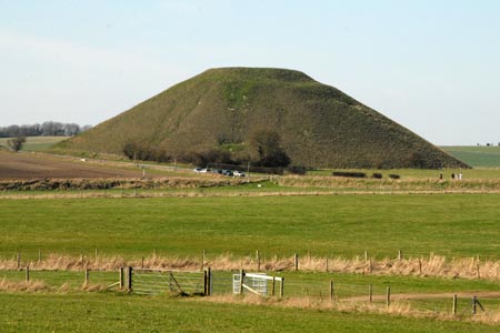
This leads you alongside a brook with an excellent view of Silbury Hill on your right, which is completely man-made and dates from about 4750 years ago. It has been calculated that it took 500 men about 15 years to construct and is the largest structure of its kind in Europe. Access to hill is not possible so you have to be content to enjoy it from a distance.
Continue to the A4 main road. Cross with care and take the signed footpath opposite. This leads without any navigational problems across a field. You will see people ahead making the final ascent to the West Kennett Long Barrow which is remarkably well preserved. Information boards explain its history.
All that remains is to retrace your steps back to Avebury perhaps continuing into the village to explore the Stone Circle and also for refreshment.
Other walks nearby
| Walk 3517 | Avebury & Overton Down | easy/mod | 7.5 miles |
| Walk 2357 | Grey Wethers & Fyfield Down from Hackpen White Horse | easy/mod | 8.5 miles |
| Walk 2339 | Milk Hill the highest point in Wiltshire | easy | 3.0 miles |
| Walk 1807 | The Southern Escarpment of the Marlborough Downs | easy/mod | 6.5 miles |
| Walk 1733 | Wessex Downs & Kennet & Avon Canal from Pewsey | easy/mod | 8.0 miles |
| Walk 3295 | Pewsey Hill and Fyfield Down | easy/mod | 9.0 miles |
| Walk 1928 | Pewsey Downs from Wootton Rivers | easy/mod | 8.0 miles |
| Walk 2255 | Urchfont Hill from Market Lavington | easy/mod | 8.6 miles |
| Walk 2699 | Lacock - a village stroll | easy | 1.0 miles |
| Walk 2410 | Wayland's Smithy, Ashdown House and Ashbury | easy/mod | 7.5 miles |
Recommended Books & eBooks
Walking in the North Wessex Downs
 30 walking routes exploring the North Wessex Downs Area of Outstanding Natural Beauty (AONB). The routes are between 7km to 20km through this peaceful rolling chalk landscape covering parts of four counties: Berkshire, Hampshire, Wiltshire and Oxfordshire, with descriptions to reach the highest points in each one.
More information
The Kennet and Avon Canal
 Guidebook to walking along the Kennet & Avon Canal. The 94 mile route from Reading to Bristol is split into 7 stages of fairly easy walking and includes the UNESCO World Heritage Site of Bath and Bristol's Floating Harbour. 20 circular walks are also included, ranging from 4¼ to 9 miles, taking in the best sections of the canal.
More information
Messaging & Social Media
Message Walking Britain and follow the latest news.

Mountain Weather
Stay safe on the mountains with detailed weather forecasts - for iOS devices or for Android devices.