Milk Hill the highest point in Wiltshire
Wiltshire Walk
County/Area - Wiltshire
Author - Lou Johnson
Length - 3.0 miles / 4.9 km Ascent - 400 feet / 121 metres
Time - 1 hours 50 minutes Grade - easy
Walk Route Description
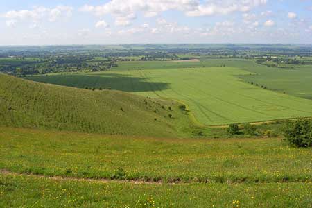
Click image to see photo description.
This short walk takes you to the highest point in Wiltshire, which despite its status probably offers less of a view than many points nearby! The route is easy to follow and apart from Milk Hill's summit offers some wonderful views across the downland and passes some points of interest along the way. The start is a small car park on the minor road between Lockeridge and Alton Barnes at grid ref. SU116638.
After parking, cross the road and take the path heading southwest through a field climbing gently across the northern flank of Walkers Hill. At a junction of paths (grid ref. SU112635). Here bear right and follow the path towards Milk Hill that passes above the White Horse carved in the grassland. The path turns north with a flat filed on your right that forms the summit area of Milk Hill. The highest point is not that marked on OS maps but a point surrounded by the 295 metre contour on maps. This can be accessed via a gate and you can then decide for yourself which is the highest point!
To continue follow the path north to Wansdyke which is a medieval defensive ditch. Here turn right along the White Horse Trail. After just over 400 metres bear right on to a path that descends gradually back to the road and the start of the walk.
Maps 

| Ordnance Survey Explorer 157 | Sheet Map | 1:25k | BUY |
| Anquet OS Explorer 157 | Digital Map | 1:25k | BUY |
| Ordnance Survey Digital Map Subscription | |||
| Latest Ordnance Survey Discounts | |||
Other walks nearby
| Walk 1807 | The Southern Escarpment of the Marlborough Downs | easy/mod | 6.5 miles |
| Walk 3517 | Avebury & Overton Down | easy/mod | 7.5 miles |
| Walk 1733 | Wessex Downs & Kennet & Avon Canal from Pewsey | easy/mod | 8.0 miles |
| Walk 3295 | Pewsey Hill and Fyfield Down | easy/mod | 9.0 miles |
| Walk 2812 | Avebury, West Kennett and Silbury Hill | easy/mod | 7.0 miles |
| Walk 3417 | Silbury Hill and West Kennett Long Barrow from Avebury | easy | 3.0 miles |
| Walk 3318 | Hackpen Hill & Overton Down | easy/mod | 9.5 miles |
| Walk 2377 | Highlights of Avebury | easy/mod | 8.8 miles |
| Walk 1928 | Pewsey Downs | easy/mod | 8.0 miles |
| Walk 2357 | Grey Wethers & Fyfield Down from Hackpen White Horse | easy/mod | 8.5 miles |
Recommended Books & eBooks
The Kennet and Avon Canal
 Guidebook to walking along the Kennet & Avon Canal. The 94 mile route from Reading to Bristol is split into 7 stages of fairly easy walking and includes the UNESCO World Heritage Site of Bath and Bristol's Floating Harbour. 20 circular walks are also included, ranging from 4¼ to 9 miles, taking in the best sections of the canal.
More information
