Pewsey Hill and Fyfield Down
Wiltshire Walk
County/Area - Wiltshire
Author - Lou Johnson
Length - 9.0 miles / 14.6 km Ascent - 700 feet / 212 metres
Time - 5 hours 10 minutes Grade - easy/mod
Walk Route Description
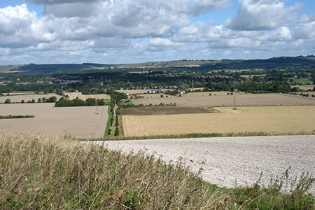
Click image to see photo description.
This circular walk from Pewsey first visits the White Horse on Pewsey Hill. The route keeps to the high ground enjoying views across the Vale of Pewsey from Fyfield Down before descending to pass through the attractive village of Milton Lilbourne. Field paths and bridleways are then used to reach the Kennet and Avon Canal for a pleasant return back to the start.
The start is the car park by Pewsey Library (grid ref. SU163601) which is located on Goddard Street. After parking return to Market Place (A345) and turn right. At the monument turn left into High Street (B3087). Continue through the village centre for 500 metres to reach a road junction (grid ref. SU169602) and turn right to Southcott along Ball Road. Follow Ball Road passing the Coopers Arms on your left.
Shortly after the lane forks. Fork right into Easterton Lane, continue as the lane bends right to reach the entrance to Pewsey Vale FC. Bear left down another lane keeping the football ground on your right. After 100 metres turn left onto a signed footpath. Continue ahead over Raffin Lane and follow the path around the back of houses to Swan Meadow. Turn left and continue ahead to join a signed path opposite (grid ref. SU167595). Follow the path across the right-hand side of the field to Green Drove. Turn right and then left to join a gravel track (signed as a bridleway).
This track, with the White Horse in view ahead, leads to a stile near the foot of Pewsey Hill. Continue up the hillside to the Pewsey White Horse, which is enclosed by a fence. Head to the top of the fence and turn left along a path on the high ground running parallel to a fence above. You now have the chance to enjoy a fine view across the Vale of Pewsey for the next section of the walk. Continue to the fence corner (grid ref. SU174581). Maintain direction across a shallow dip. Pass between a row of small trees and then bear half right to join a clear track leading to a small stand of trees (Victory Clump).
Keep to the left of these trees and follow the path to the left of a fence. Continue onto Fyfield Down where the path swings north along the right-hand field edge. Continue to a fence corner (grid ref. SU189589) and turn right walking parallel to the fence on your right. At the fence corner, turn left and then right to follow a path with the fence on your right. The path joins a clearer track which descends across the hillside. Aim to the right of the barn and join a clear track heading north (grid ref SU194594). Where the track bends left, go half right, and pass behind Priory Cottage to a road (grid ref. SU192598).
Bear left along the lane and walk into Milton Lilbourne. Continue ahead through the village to pass St. Peter's church on your left. Reaching the Manor House on the left, take the signed footpath on the right. After 100 metres go half left and maintain direction across several fields to reach Burbage Road B3087). Cross carefully and take the path slightly to your right. Head north across a field and then walk half right across the second field to a road (grid ref. SU194615).
Turn right and after 50 metres, turn left onto a signed bridleway through a metal gate. The route leads through Totteridge Farm and continues west to a road at New Mill (grid ref. SU184618). Turn right under the railway and then keep right at the next junction to the Kennet & Avon Canal. Turn left through the gate to join the towpath. You now have about 2.5 kilometres of east walking along the canal.
Continue along the canal until you reach Pains Bridge (the second bridge after joining the towpath). Leave the canal and turn south along the White Horse Trail. Just before the railway, turn right up a road with houses either side. Continue on a footpath running parallel to the railway. This leads into Buckleaze Lane which passes under the railway to join the A345> turn left into Pewsey along North Street. Continue ahead at the roundabout into Market Place and then right onto Goddard Street and the start.
Maps 

| Ordnance Survey Explorer 157 | Sheet Map | 1:25k | BUY |
| Anquet OS Explorer 157 | Digital Map | 1:25k | BUY |
| Ordnance Survey Explorer 130 | Sheet Map | 1:25k | BUY |
| Anquet OS Explorer 130 | Digital Map | 1:25k | BUY |
| Ordnance Survey Digital Map Subscription | |||
| Latest Ordnance Survey Discounts | |||
Other walks nearby
| Walk 1733 | Wessex Downs & Kennet & Avon Canal from Pewsey | easy/mod | 8.0 miles |
| Walk 1928 | Pewsey Downs | easy/mod | 8.0 miles |
| Walk 1807 | The Southern Escarpment of the Marlborough Downs | easy/mod | 6.5 miles |
| Walk 2339 | Milk Hill the highest point in Wiltshire | easy | 3.0 miles |
| Walk 3517 | Avebury & Overton Down | easy/mod | 7.5 miles |
| Walk 2812 | Avebury, West Kennett and Silbury Hill | easy/mod | 7.0 miles |
| Walk 3417 | Silbury Hill and West Kennett Long Barrow from Avebury | easy | 3.0 miles |
| Walk 3318 | Hackpen Hill & Overton Down | easy/mod | 9.5 miles |
| Walk 2377 | Highlights of Avebury | easy/mod | 8.8 miles |
| Walk 2357 | Grey Wethers & Fyfield Down from Hackpen White Horse | easy/mod | 8.5 miles |
Recommended Books & eBooks
The Kennet and Avon Canal
 Guidebook to walking along the Kennet & Avon Canal. The 94 mile route from Reading to Bristol is split into 7 stages of fairly easy walking and includes the UNESCO World Heritage Site of Bath and Bristol's Floating Harbour. 20 circular walks are also included, ranging from 4¼ to 9 miles, taking in the best sections of the canal.
More information
