Cringle Moor & the Wain Stones
North York Moors Walk
Nat Park - North York Moors - North York Moors West
County/Area - North Yorkshire
Author - Peter Smyly
Length - 6.0 miles / 9.8 km Ascent - 800 feet / 242 metres
Time - 3 hours 50 minutes Grade - easy/mod
Walk Route Description
Click image to visit gallery of 6 images.
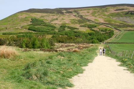
This is a walk featuring part of the Cleveland Way on the North Yorkshire Moors along a ridge to the south of Great Broughton, featuring three tops of similar heights. The walk covers a small part of Alfred Wainwright's famous "Coast to Coast" walk and the area is a popular spot for hang gliders. Paths are clear throughout the route and the three hills on the ridge entail a certain amount of steep ascents and descents, but normally on well-constructed stone paths. There are pleasant views of hills and countryside throughout and the highlight of the walk is the assortment of rocks and boulders near the highest point of the third top, known as the Wain Stones. This route suggests returning by the low level path which borders the escarpment to the north, the route bypassing the three hills as it undulates gently instead. This is a walk that could easily be completed in an afternoon.
Start at the Lord Stones' car park at the Carlton Bank end of the ridge to the west where there is a subterranean café and public conveniences. Take the obvious path through the trees and follow the waymarked trail ahead, passing a plantation of trees on the left before following the path up to the first top, marked by a stone chair, large enough to seat at least two people. The view to the north is especially apparent throughout with green and yellow fields and scattered settlements such as Great Ayton and Great Broughton with the distinctive profile of Roseberry Topping beyond and Urra Moor to the right of it. Further away still, the industrial chimneys of the Middlesbrough area can be seen. The view back to the car park shows a path clearly going up the ridge on the other side. The path ahead now follows a more or less level trajectory through the heather with rock outcrops on the left and then the route descends steeply in places to the next dip. Going up and down each of the three hills is entirely optional as there is a path on the edge of the escarpment that skirts all three of them, a route which is suggested for the way back to avoid a straight "there and back".
After the second top has been ascended and then descended down to the dip known as Garfit Gap, the next top saves the best until last with the prospect of the Wain Stones drawing ever nearer. Seen from the second top, if you haven't visited them before, there is nothing to suggest how dramatic they are until you get much closer to them, especially on the walk up the final slope to reach them. This approach is the steepest section of the walk but any toil is barely noticeable as the rocks and boulders loom ever larger on approach and the path weaves its way between them to lead to the top of the ridge above the stones. This is a popular spot for rock climbers with ropes and helmets. This is the most interesting and picturesque bit of the walk, and it is well worth pausing to stop and drink in the views.
For the return route, a descent to Garfit Gap offers the option of taking the low level route to the right all the way back to the car park with only minimal ups and downs along a very clear track. At Garfit Gap there is evidence of former mine workings in the form of old slag heaps.
Maps 

| Ordnance Survey Explorer OL26 | Sheet Map | 1:25k | BUY |
| Anquet OS Explorer OL26 | Digital Map | 1:25k | BUY |
| Ordnance Survey Digital Map Subscription | |||
| Latest Ordnance Survey Discounts | |||
Other walks nearby
| Walk 1469 | Carlton Bank, Scugdale, Raisdale & Kirby Bank | moderate | 10.5 miles |
| Walk 1468 | Wain Stones, Bank Foot & Bloworth Crossing | moderate | 14.3 miles |
| Walk 1544 | Chop Gate, Round Hill & Stumps Cross | moderate | 10.1 miles |
| Walk 1473 | Hollin Hill to Square Corner by the Cleveland Way | moderate | 9.5 miles |
| Walk 1497 | High Paradise around Arden Great Moor from Square Corner | moderate | 14.3 miles |
| Walk 3718 | Scarth Wood Moor from Osmotherley | easy/mod | 6.0 miles |
| Walk 1330 | Roseberry Topping & Captain Cook's Monument | easy/mod | 6.5 miles |
| Walk 1467 | Cleveland Way - Roseberry Common to Tidy Brown Hill | moderate | 15.0 miles |
| Walk 3160 | Roseberry Topping and Captain Cook's Monument | easy/mod | 6.3 miles |
| Walk 2930 | Roseberry Topping from Newton under Roseberry | easy | 3.2 miles |
Recommended Books & eBooks
The Cleveland Way Map Booklet
 Map booklet of the Cleveland Way National Trail, a 177km (110 mile) walk around the North York Moors National Park. This booklet is included with the Cicerone guidebook to the Cleveland Way and the Yorkshire Wolds Way, and shows the full route of the Cleveland Way on Ordnance Survey 1:25,000 maps.
More information
Trail and Fell Running in the Yorkshire Dales
 Guidebook to 40 of the best trail and fell runs in the Yorkshire Dales National Park. Ranging from 5 to 24 miles, the graded runs start from bases such as Ribblehead, Dent, Sedbergh, Malham and Grassington and take in the region's diverse delights, from castles and waterfalls to iconic mountains such as Whernside, Ingleborough and Pen Y Ghent.
More information
