Rolleston from Billesdon
Leicestershire Walk
County/Area - Leicestershire
Author - David McMahon
Length - 5.3 miles / 8.6 km Ascent - 350 feet / 106 metres
Time - 3 hours 0 minutes Grade - easy
Walk Route Description
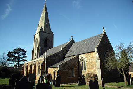
Click image to see photo description.
The Leicestershire village of Billesdon lies nine miles east of Leicester just off the A47. Centrebus Service 747 Leicester to Uppingham provides a bus service and there is on street parking available near the village centre. However, do park with consideration for local residents.
From the Market Place (grid ref. SK719028) walk south along Church Lane past John the Baptist church and on to the outskirts of the village. Ignore the footpath on the left and then take the one on the right. Continue along the alleyway and turn left when it opens out onto an oval. Take the alleyway to the left further along and then go right when it opens out onto a grassy patch. Head along this well-marked footpath, through the fields, until you cross a driveway. Carry on through two fields and then you have an option. You can continue along the footpath to a point to the left of the houses on the opposite side of the field, or turn left immediately after the hedgerow onto the unmarked bridleway and walk along it until you reach Ashlands Road (grid ref. SK719005).
Turn left along the lane and walk to the junction with the B6047. Turn right and then left through the Cranhill Estate. Carry on along the driveway and on into the field. Then turn left through the gate at the yellow post. Walk parallel to the left-hand side of the field until you reach the other end and go diagonally right once you are into the next field. When you reach a driveway turn right, pass through the gate and continue until you reach a road junction.
Follow the road as it snakes to the right and then left; then turn sharp left along the road marked 'Private. Bridleway Only' and into Rolleston. Continue along this road until you reach an ivy-covered wall. Here you will see a stile on your left. Cross the stile and go right to the side of the hump. Over another stile and then another. Carry on in a straight line with Skeffingon Vale,ahead and slightly to your right. But when you drop down to the stream (grid ref. SK738011), do not cross it, but turn left and walk along the headland to the road. This short cut should only be undertaken with permission from the landowner as it is not a right of way. Please see the note at the end of this walk description.
Turn right along the road until you reach a footpath on your left opposite the driveway to Skeffington Vale (grid ref. SK738013). Cross the stile and walk diagonally right. Go diagonally left when you are into the next field. Go to the right of the hedgerow and continue along the headland and follow it round to the right. Drop down the slope, cross the footbridge and up the other side to a gate on your left. Go diagonally right up the slope and eventually you will see a yellow post at the end of a hedgerow. Go left after it and continue up the slope. Carry on until you reach the road (grid ref. SK727021). Cross the road and follow the continuing footpath then using the church steeple as a marker. Continue until you come out onto the stile you were told to ignore at the start of the walk. Turn right and walk back to your starting point. Congratulations. Hope you have enjoyed yourself!
Note If you have not received consent from the landowner continue on the path past Skeffington Vale to the village of Skeffington. Reaching the road (grid ref. SK744025), turn left and walk through the village passing the parish church on your right. Reaching a road junction, turn left and follow the road for just under a mile to re-join the route as described at grid ref. SKSK738013 by taking the footpath on your right.
Maps 

| Ordnance Survey Explorer 233 | Sheet Map | 1:25k | BUY |
| Anquet OS Explorer 233 | Digital Map | 1:25k | BUY |
| Ordnance Survey Digital Map Subscription | |||
| Latest Ordnance Survey Discounts | |||
Other walks nearby
| Walk 2927 | Hallaton, Glooston & Rolleston from Tugby | moderate | 12.5 miles |
| Walk 1708 | Lowesby and South Croxton | easy/mod | 7.0 miles |
| Walk 1456 | Carlton Curlieu & Illston on the Hill | easy | 5.0 miles |
| Walk 1443 | Burrough Hill & Somerby from Twyford | moderate | 11.0 miles |
| Walk 3438 | The Langtons from Stonton Wyville | easy/mod | 6.8 miles |
| Walk 2084 | Grand Union Canal from Great Glen | easy | 3.1 miles |
| Walk 1455 | Great Glen and Burton Overy circular | easy | 6.0 miles |
| Walk 1457 | Great Glen, Burton Overy, & Illston | easy/mod | 11.0 miles |
| Walk 3338 | Burton Overy from Great Glen | easy | 3.0 miles |
| Walk 2831 | Cranoe, Medbourne & Blaston from Hallaton | moderate | 11.5 miles |
