Slapton Sands & Stokenham from Torcross
Devon Walk
County/Area - Devon
Author - Lou Johnson
Length - 8.0 miles / 13 km Ascent - 1000 feet / 303 metres
Time - 5 hours 0 minutes Grade - easy/mod
Walk Route Description
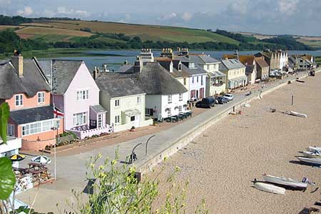
Click image to see photo description.
This Devon walk starts from the car park on the sea front at Torcross (SX823423) and then follows the South West Coast path before turning in land to explore the countryside. Returning to the coast at Bee Sands the circular route is completed by re-joining the South West Coast path back to the start.
After parking exit the car park at the northern end and follow the South West Coast path in a northerly direction for about a mile and quarter, passing a large car park on the opposite side of the main road (grid ref. SX828441) to reach a road junction. To your right is Slapton Sands which was used for training troops for the D-Day landings in France. Turn left here, cross Slapton Bridge and after just over 100 metres take the signed footpath on your left (grid ref. SX827443). This initially path follows the Shore of Slapton Ley (the lagoon on your left). At the first path junction (grid ref. SX821443) turn left. Soon after a small sewage treatment works is on your right. From here pick up the continuing path to reach a lane at grid ref. SX813445) at Deer Bridge.
Turn left up the lane past the access to Darnacombe Farm on your right. Ignore the loop road into the hamlet of Frittiscombe on your left and continue along the lane to reach Coleridge Cross (grid ref. SX801434). At the road junction take the footpath on your left. This goes half right across the first field and leads to a lane (grid ref. SX806432). Turn right along the lane into the village of Stokenham. Careful navigation is required here. Reaching a T-junction with Kiln Lane, turn right and then almost immediately left down a narrow lane. At the bottom of the lane you reach a T-junction, turn left here with the church Tower clearly in view. Follow the road around to the right passing the church on your left to reach the A379.
Turn right and almost immediately left down a lane (signed The Factory). After 150 metres take the bridleway on your right. This enclosed path leads to a lane after 500 metres (grid ref. SX806421). Turn left along the lane to the next road junction (grid ref. SX810420). Turn right through the metal gate following the waymarked path. Reaching the drive to Widdicombe House (grid ref. SX811419), keep straight ahead following the right of way around the west side of the buildings and south past Lower Widdicombe Farm on your right to reach a lane in Beeson village (grid ref. SX811409).
Turn left along the lane and continue to a T-junction (grid ref. SX812407). Turn left here and walk along the undulating lane for about 600 metres to a sharp left hand bend. Continue to the next right hand bend and take the footpath on your left through a wooden gate (grid ref. SX817406). Follow this path down to join the South West Coast Path at grid ref. SX820407). Turn left along this National Trail and continue north. You will pass another lagoon on your left (Widdicombe Ley) and just after this and before the white house (Sunnydale) turn left and follow the South West Coast Path which is followed back to Torcross and the start of the walk.
Maps 

| Ordnance Survey Explorer OL20 | Sheet Map | 1:25k | BUY |
| Anquet OS Explorer OL20 | Digital Map | 1:25k | BUY |
| Ordnance Survey Digital Map Subscription | |||
| Latest Ordnance Survey Discounts | |||
Other walks nearby
| Walk 3431 | Beeson to Salcombe | mod/hard | 12.0 miles |
| Walk 1857 | Start Point & East Prawle | moderate | 8.2 miles |
| Walk 1866 | East Prawle & Prawle Point | easy/mod | 4.1 miles |
| Walk 2474 | East Prawle Coast Circular | easy/mod | 5.6 miles |
| Walk 3432 | Salcombe to Thurlestone | mod/hard | 11.0 miles |
| Walk 2371 | Kingswear to Brixham | moderate | 10.8 miles |
| Walk 3587 | Kingswear from Coleton Fishacre | moderate | 7.0 miles |
| Walk 2461 | Warren Point & Bolt Tail from Bantham | moderate | 9.0 miles |
| Walk 3041 | Thurlestone circular | easy | 4.0 miles |
| Walk 1323 | Broadsands Beach and Brixham | easy | 4.0 miles |
Recommended Books & eBooks
South West Coast Path Map Booklet - St Ives to Plymouth
 Map of part of the southern section of the 630 mile (1014km) South West Coast Path National Trail. Covers the trail from St Ives to Plymouth along the west Cornwall and Devon coastline. This convenient and compact booklet of Ordnance Survey 1:25,000 maps shows the route, providing all of the mapping you need to walk the trail in either direction.
More information
The South West Coast Path
 Guidebook to walking the entire South West Coast Path National Trail. The route runs for 630 miles from Minehead to Poole along the north Devon, Cornish, south Devon and Dorset coastline. Divided into 45 stages, this long-distance coastal trek could be completed within 4 weeks, or walked in sections. Guide includes maps and essential information.
More information
