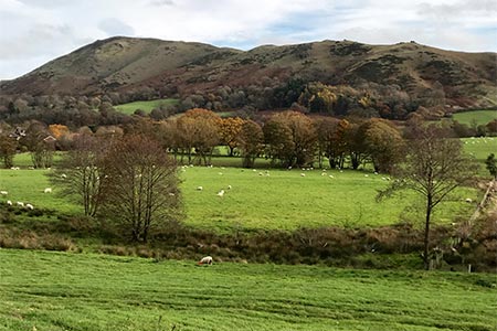
Caer Caradoc, Hope Bowdler & Willstone Hills from Cardington
Shropshire Hills Walk
Region - Shropshire Hills
County/Area - Shropshire
Author - Daryl Smith
Length - 7.0 miles / 11.4 km Ascent - 1700 feet / 515 metres
Time - 5 hours 10 minutes Grade - moderate
Walk Route Description
Click image to visit gallery of 6 images.
A lovely hill walk that avoids crowds and starts from the delightful Shropshire village of Cardington. The sheer quiet of the countryside here belies its turbulent past, this was hotly disputed border country long before the time of the Marcher Lords.
Our walk is based on the pretty, conservation village of Cardington, tucked away in beautiful countryside about three miles to the north-east of Church Stretton. Cardington is best approached from the A49 either from Church Stretton or from Leebotwood a few miles north. There are no public facilities in Cardington other than the Royal Oak, a "picture-book" country pub both ancient and charming. There is usually plenty of room on the village hall car park, immediately opposite the church; parking is free although donations are requested. St James' Church is itself worth a visit if only to see a panorama mural created by local people.
Go left out of the car park and head out of the village taking a lane on the right signposted for Willstone and Caer Caradoc Hill; stay on the lane until it turns sharp right then carry on straight ahead on a farm track. You will soon get a fine view of Caer Caradoc ahead with Hope Bowdler and Willstone Hills off to your left. Ignore the first two signed footpaths on your right and leave the track by the third, just beyond a road gate and an information board, head across the field where Caradoc soon comes back into sight with The Lawley beyond.
To make the most of the ridge traverse don't go for the direct ascent that is now visible, go through into access land and then go right gradually gaining height until you reach the northern end of the ridge. Simply follow the ridge of Caer Caradoc Hill for its entirety, taking time to explore the summit where outlines of earthwork fortifications dating back to the Iron Age and possibly beyond can still be seen. This hill fort is reputedly the location of the last stand of Celtic chieftain Caradoc (or Caractacus) against the might of Rome. There is a small cave known as Caractacus' Cave on the north-western side of the summit where he is said to have hidden after the final battle.
Westerly views are of course dominated by the bulk of the Long Mynd; there are excellent wide-ranging views in all other directions. Looking ahead, the next ridge walk from the Gaer Stone to the Battlestones is clearly visible. Continue down the ridge line past Three Fingers Rock, through a kissing gate then on the lower slope veer right to a footbridge over the small stream. On the opposite bank go left to a gate giving access to a path around the base of Helmeth Hill; this gate can be difficult to spot when vegetation is in full leaf (it is just above and to the left of the ford). Helmeth Hill's natural woodland is open to explore if you wish to detour from the main walk.
Our path around the hill follows an often muddy track then swings left over fields to the foot of Hope Bowdler Hill. Back in access land at the toe of the slope, contour around to your right until you reach the end of the ridge below the Gaer Stone. Follow a clearly defined ridge walk over Hope Bowdler Hill and onto Willstone Hill. Wander left off the main path to Battlestones and you can see the lovely setting of Cardington below. At the end of the ridge look down south-east to a field corner, go through the kissing gate at that corner and left along the hedge line then straight ahead on a surfaced farm track. Follow the concrete road past North Hill Farm and just before the start of the highway (tarmac surface) turn right onto a footpath. After the first field go diagonally left past the Sharpstones and then through a gate turning left on the lane. Your map will offer a choice of field paths back to Cardington but it is just as pleasant to stroll down the quiet country lane into the village.
Maps 

| Ordnance Survey Explorer 217 | Sheet Map | 1:25k | BUY |
| Anquet OS Explorer 217 | Digital Map | 1:25k | BUY |
| Ordnance Survey Digital Map Subscription | |||
| Latest Ordnance Survey Discounts | |||
Other walks nearby
| Walk 1097 | Caer Caradoc | easy/mod | 3.5 miles |
| Walk 2678 | Wenlock Edge & Broadstone | easy/mod | 6.4 miles |
| Walk 1321 | Caer Caradoc & Hope Bowder Hill | moderate | 9.0 miles |
| Walk 3048 | Caer Caradoc & The Lawley | moderate | 10.0 miles |
| Walk 3308 | Ragleth and the Long Mynd | mod/hard | 11.0 miles |
| Walk 3449 | Ragleth, the Long Mynd & Ratlinghope | hard | 18.0 miles |
| Walk 1374 | Lightspout Waterfall and Pole Bank | easy/mod | 5.8 miles |
| Walk 1180 | Pole Bank (Long Mynd) from Carding Mill | moderate | 6.5 miles |
| Walk 1409 | Haddon Hill and Bodbury Hill | easy/mod | 4.4 miles |
| Walk 2159 | Lightspout Hollow, Pole Bank & Ashes Hollow | moderate | 7.3 miles |
Recommended Books & eBooks
Hillwalking in Shropshire
 Guidebook to 32 walking routes in Shropshire in the West Midlands. The routes range from 3 miles (5km) to 12 miles (19km), taking in highlights such as The Wrekin, Wenlock Edge, Long Mynd and Stiperstones, Castle Ring and Bury Ditches. Many routes start near delightful towns and villages including Church Stretton, Ludlow and Bishops Castle.
More information
