Foel Cwmcerwyn from Rosebush, Preseli Hills
Pembrokeshire Coast Walk
Nat Park - Pembrokeshire Coast
County/Area - Pembrokeshire
Author - Lou Johnson
Length - 5.0 miles / 8.1 km Ascent - 900 feet / 273 metres
Time - 3 hours 20 minutes Grade - moderate
Walk Route Description
Click image to see photo description.
This Preseli Hills walk takes you to Foel Cwmcerwyn which the highest summit in the range. The walk starts from the village of Rosebush which lies to the north of the B4313. Approaching from the south turn right into the village and continue for 600 metres to turn left (just before the telephone box) to reach the car park (grid ref. SN075295).
After parking, return to the telephone box and take the signed footpath opposite. Follow the path uphill keeping to the left of the farm. Maintain direction to reach a track (grid ref. SN080294). Turn left and follow the track which heads in a generally north-easterly direction with Pantmaenog Forest on your left. After 1.6 kilometres leave the track where it veers to the right and continue alongside the forest until you reach the corner of the plantation (grid ref. SN092307).
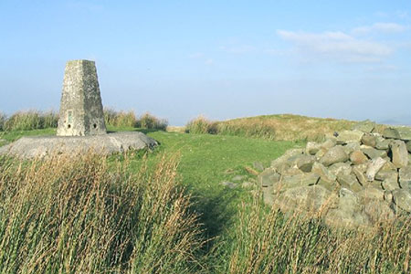
From this point a clear path heads just east of north to climb more steeply onto the summit of Foel Cwmcerwyn and the OS trig point (536 metres). The 360-degree panorama is worth enjoying before you continue north on what can be a wet section of path. You need to aim for the far end of the forest where you can join the 'Golden Road' which runs the length of the Preseli Hills ridge from west to east.
Turn left and follow the clear path for 700 metres descending to the col at Bwlch Pennant (grid ref. SN085321). Turn left again and head south on a descending track through Pantmaenog Forest. Ignore all side tracks and keep straight ahead for three kilometres back to the telephone box and the car park.
Maps 

| Ordnance Survey Explorer OL35 | Sheet Map | 1:25k | BUY |
| Anquet OS Explorer OL35 | Digital Map | 1:25k | BUY |
| Ordnance Survey Digital Map Subscription | |||
| Latest Ordnance Survey Discounts | |||
Other walks nearby
| Walk 3466 | The Preseli Ridge along the Golden Road | moderate | 6.4 miles |
| Walk 3465 | Foel Eryr Circular, Preseli Hills | moderate | 6.0 miles |
| Walk 3468 | Foel Drygarn Hillfort, Preseli Hills | easy | 1.8 miles |
| Walk 3467 | Foel Drygarn Hillfort circular, Preseli Hills | easy/mod | 3.7 miles |
| Walk 2291 | Mynydd Carningli from Newport | easy/mod | 4.5 miles |
| Walk 3474 | Dinas Island from Cwm-yr-Eglwys | easy | 3.0 miles |
| Walk 3494 | Pwllygranant & Cebwr Bay from Moylgrove | mod/hard | 8.5 miles |
| Walk 3479 | Strumble Head & Garn Fawr Hillfort | moderate | 6.8 miles |
| Walk 3482 | Garn Fawr & Garn Fechan Hillforts | easy | 1.5 miles |
| Walk 3480 | Strumble Head from Garn Fawr | easy/mod | 5.0 miles |
Recommended Books & eBooks
The Wales Coast Path
 A single guidebook to walking the whole Wales Coast Path - 1400km (870 miles) the length of Wales from Chester to Chepstow, including Anglesey, described in 57 stages. The route passes through the Snowdonia and Pembrokeshire National Parks and many AONBs and can be linked with the Offa's Dyke Path for a complete circuit of Wales.
More information
