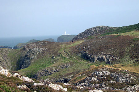
Strumble Head from Garn Fawr
Pembrokeshire Coast Walk
Nat Park - Pembrokeshire Coast
County/Area - Pembrokeshire
Author - Lou Johnson
Length - 5.0 miles / 8.1 km Ascent - 900 feet / 273 metres
Time - 3 hours 20 minutes Grade - easy/mod
Walk Route Description
Click image to see photo description.
A Pembrokeshire walk exploring the coast south of Strumble. The route also includes an ascent of the volcanic Garn Fawr which was the site of an Iron Age Hillfort. The route uses country lanes to reach Strumble Head from where the Pembrokeshire Coast Path is followed for most of the way back to the start. The final section over Garn Fawr provides an excellent panorama of the coast and countryside just visited.
The start is the small car park lying to the east of Garn Fawr (grid ref. SM899388). Exit the car park and turn left and follow the lane downhill for 1.5 kilometres. On this section you pass the farm at Caerlem to reach T-junction (grid ref. SM903399). Turn left signed to Strumble Head and follow the road for 1.5 kilometres to reach Strumble Head.
Descend the road towards the lighthouse to turn left onto the signed Pembrokeshire Coast Path (grid ref. SM895412). The path heads along the cliff tops in a southerly direction offering easy and relaxed walking. Stay on the coast path for just over 4 kilometres enjoying the beautiful coastal scenery until you reach a lane (grid ref. SM893388).
Cross the road and take the waymarked left-hand driveway following it as it bends to the right. Continue straight ahead to join the path climbing onto Garn Fawr. The path climbs steeply to the right of an obvious crag to reach the summit from where you can enjoy a panorama that includes the route just completed. To complete the walk, descend on the clear path that follows a wall (on your left) down to the carpark below.
Maps 

| Ordnance Survey Explorer OL35 | Sheet Map | 1:25k | BUY |
| Anquet OS Explorer OL35 | Digital Map | 1:25k | BUY |
| Ordnance Survey Digital Map Subscription | |||
| Latest Ordnance Survey Discounts | |||
Other walks nearby
| Walk 3481 | Carregwastad Point & Strumble Head Circular | moderate | 7.7 miles |
| Walk 1434 | Abercastle & Trefin Circular | moderate | 7.5 miles |
| Walk 3477 | Porthgain, Abereiddi Bay & Blue Lagoon | easy | 3.7 miles |
| Walk 3474 | Dinas Island from Cwm-yr-Eglwys | easy | 3.0 miles |
| Walk 3476 | Porthgain & Blue Lagoon from Abereiddy | easy/mod | 6.5 miles |
| Walk 2291 | Mynydd Carningli from Newport | easy/mod | 4.5 miles |
| Walk 2056 | Pointz Castle from Solva | easy/mod | 5.5 miles |
| Walk 3466 | The Preseli Ridge along the Golden Road | moderate | 6.4 miles |
| Walk 3465 | Foel Eryr Circular, Preseli Hills | moderate | 6.0 miles |
| Walk 1997 | St. David's & Coast Path Circular | moderate | 9.7 miles |
Recommended Books & eBooks
The Wales Coast Path
 A single guidebook to walking the whole Wales Coast Path - 1400km (870 miles) the length of Wales from Chester to Chepstow, including Anglesey, described in 57 stages. The route passes through the Snowdonia and Pembrokeshire National Parks and many AONBs and can be linked with the Offa's Dyke Path for a complete circuit of Wales.
More information
