Porthgain & Blue Lagoon from Abereiddy
Pembrokeshire Coast Walk
Nat Park - Pembrokeshire Coast
County/Area - Pembrokeshire
Author - Lou Johnson
Length - 6.5 miles / 10.6 km Ascent - 700 feet / 212 metres
Time - 4 hours 0 minutes Grade - easy/mod
Maps 

| Ordnance Survey Explorer OL35 | Sheet Map | 1:25k | BUY |
| Anquet OS Explorer OL35 | Digital Map | 1:25k | BUY |
Walk Route Description
Click image to see photo description.
This Pembrokeshire walk starts from the beach Abereiddy and the crosses pleasant rural scenery to reach the coast just to the west of Trefin. The route then follows the Pembrokeshire Coast Path through Porthgain, with its bustling harbour, to pass Traeth Llyfn and the Blue Lagoon back to the start. The paths are well-signed, and the route offers a relaxing walk along the beautiful coast.
The start is the parking area behind the beach at Abereiddy (grid ref. SM797312). After parking exit the rear of the car park following the signed Pembrokeshire Coast Path north (sea on your left). Turn right on the signed footpath that passes in front of the white walled toilet block. Continue on a rising path across the hillside to join a track. Entering a field, walk half right to reach a path junction (grid ref. SM802317). Turn right here and follow a track with the field boundary on your immediate right. Continue through the Ynys Barry Holiday Cottage complex to reach a road.
Turn left towards Porthgain. After a short distance turn right onto a signed footpath by a wooden gate. Cross two fields to reach a driveway at Felindre House. Go left along the drive and follow the track as it bends to the right. At the next junction of tracks (with Henllys Farm ahead) turn right. Follow the clear track as it curves left. Continue ahead between hedges. The path then enters a failed with a hedge on your right. Follow the path into a smaller field where you walk half right to a gate and a lane.
Turn left down the lane and continue for 600 metres. Immediately after a single storey house on the left (Swyn-y-Don) turn left onto the signed Pembrokeshire Coast Path at a gate (grid ref. SM823323). You now have a very pleasant walk along the coast to Porthgain. The walking is easy and the path well-signed. As you approach Porthgain, you will see the white landmarks showing the entrance to the harbour. Descend to the harbour where refreshments are available in season.
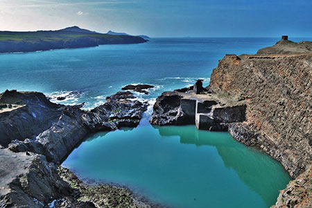
Turn right and follow the quayside around to the far side of the harbour. The Coast Path bears sharp left up some steps before gaining the cliff tops once more. Another section of pleasant and relaxing walking takes you above the sands of Traeth Llyfn beyond which you soon get a bird's eye view of the Blue Lagoon. This former quarry has now become a local attraction. Stay on the descending Coast Path back to the start.
Other walks nearby
| Walk 3477 | Porthgain, Abereiddi Bay & Blue Lagoon | easy | 3.7 miles |
| Walk 1434 | Abercastle & Trefin Circular | moderate | 7.5 miles |
| Walk 2056 | Pointz Castle from Solva | easy/mod | 5.5 miles |
| Walk 1997 | St. David's & Coast Path Circular | moderate | 9.7 miles |
| Walk 2057 | St. David's Head & Carn Llidi | easy/mod | 4.5 miles |
| Walk 3483 | Penberry & St Davids Head from Whitesands Bay | moderate | 9.0 miles |
| Walk 1210 | Porth Clais & St Justinian's | easy/mod | 5.5 miles |
| Walk 3479 | Strumble Head & Garn Fawr Hillfort | moderate | 6.8 miles |
| Walk 3482 | Garn Fawr & Garn Fechan Hillforts | easy | 1.5 miles |
| Walk 3480 | Strumble Head from Garn Fawr | easy/mod | 5.0 miles |
Recommended Books & eBooks
The Wales Coast Path
 A single guidebook to walking the whole Wales Coast Path - 1400km (870 miles) the length of Wales from Chester to Chepstow, including Anglesey, described in 57 stages. The route passes through the Snowdonia and Pembrokeshire National Parks and many AONBs and can be linked with the Offa's Dyke Path for a complete circuit of Wales.
More information
Messaging & Social Media
Message Walking Britain and follow the latest news.

Mountain Weather
Stay safe on the mountains with detailed weather forecasts - for iOS devices or for Android devices.