Porthgain, Abereiddi Bay & Blue Lagoon
Pembrokeshire Coast Walk
Nat Park - Pembrokeshire Coast
County/Area - Pembrokeshire
Author - Lou Johnson
Length - 3.7 miles / 6 km Ascent - 400 feet / 121 metres
Time - 2 hours 20 minutes Grade - easy
Maps 

| Ordnance Survey Explorer OL35 | Sheet Map | 1:25k | BUY |
| Anquet OS Explorer OL35 | Digital Map | 1:25k | BUY |
Walk Route Description
Click image to see photo description.
This excellent Pembrokeshire Walk starts from the harbour village of Porthgain and then crosses Ynys Barry to Abereiddi Bay. The route then returns to the start following the Pembrokeshire Coast Path. The coastal section of the walk passes the Blue Lagoon, the sands of Traeth Llfyn and a scenic section of coast before returning to the start.
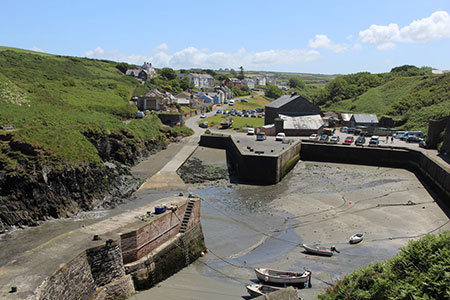
The start is the car park at Porthgain (grid ref. SM815321). Leave the car park and follow the road you used to reach Porthgain. Continue up the road for 800 metres. You will pass a footpath sign and gate on the left. A short way beyond this bear right down a tarmac lane. Continue along this lane and walk past the Ynys Barry Holiday Cottage complex. Join a track and follow this for 800 metres where the field boundary turns left at 45 degrees. Initially follow the wall and where the wall turns left again cut across the field to a gate. Once through the gate follow a track across the hillside towards the sea passing to the right of a white painted toilet block.
Beyond the toilets turn right and join the Pembrokeshire Coast Path with the sea on your left. You pass the entrance sign to the National Trust Ynys Barri with an information board down a side path on your left. Stay on the main path, pass through a gate and immediately take the right-hand fork. The rising path soon offers a grandstand view of the Blue Lagoon below on your left, which is a flooded former quarry. Do be careful here especially with children as there is steep drop off the path!
The coast path then offers a beautiful cliff top walk. You first pass Traeth Llfyn (beach) before cutting across a small headland to continue along a clifftop path. The path is well-signed with the National Trail Acorn symbol so you can relax and enjoy the stunning coastal scenery. The walk finishes with a descent to the quayside. Continue ahead back to the carpark.
Other walks nearby
| Walk 1434 | Abercastle & Trefin Circular | moderate | 7.5 miles |
| Walk 3476 | Porthgain & Blue Lagoon from Abereiddy | easy/mod | 6.5 miles |
| Walk 2056 | Pointz Castle from Solva | easy/mod | 5.5 miles |
| Walk 1997 | St. David's & Coast Path Circular | moderate | 9.7 miles |
| Walk 2057 | St. David's Head & Carn Llidi | easy/mod | 4.5 miles |
| Walk 3483 | Penberry & St Davids Head from Whitesands Bay | moderate | 9.0 miles |
| Walk 3479 | Strumble Head & Garn Fawr Hillfort | moderate | 6.8 miles |
| Walk 3482 | Garn Fawr & Garn Fechan Hillforts | easy | 1.5 miles |
| Walk 3480 | Strumble Head from Garn Fawr | easy/mod | 5.0 miles |
| Walk 1210 | Porth Clais & St Justinian's | easy/mod | 5.5 miles |
Recommended Books & eBooks
The Wales Coast Path
 A single guidebook to walking the whole Wales Coast Path - 1400km (870 miles) the length of Wales from Chester to Chepstow, including Anglesey, described in 57 stages. The route passes through the Snowdonia and Pembrokeshire National Parks and many AONBs and can be linked with the Offa's Dyke Path for a complete circuit of Wales.
More information
Messaging & Social Media
Message Walking Britain and follow the latest news.

Mountain Weather
Stay safe on the mountains with detailed weather forecasts - for iOS devices or for Android devices.