Carregwastad Point & Strumble Head Circular
Pembrokeshire Coast Walk
Nat Park - Pembrokeshire Coast
County/Area - Pembrokeshire
Author - Lou Johnson
Length - 7.7 miles / 12.5 km Ascent - 1200 feet / 364 metres
Time - 5 hours 0 minutes Grade - moderate
Walk Route Description
Click image to see photo description.
This Pembrokeshire walk explores the countryside and coast east from Strumble Head to Carregwastad Point where a French invasion force landed in 1797. The route uses some of the walled lanes in the area and returns along a beautiful but less used section of coast along the Pembrokeshire Coast Path. The walk is generally easy to follow although there are a couple of points along the way where careful navigation is needed.
The start is the small parking area above the lighthouse at Stumble Head (grid ref. SM895412). After parking follow the road back towards Goodwick for just over a kilometre to Tydraw (grid ref. SM901406). In the centre of the hamlet, turn left onto a tarmac track. Follow it round to the right to reach a junction of tracks after 350 metres where you continue straight ahead. In another 120 metres turn right onto an enclosed track. Follow this as it bends to the left, then right and then left again in some trees. Take the next footpath on the right (grid ref. SM907404) and follow this south for 500 metres with the field boundary on your right. The path turns sharp right across a stile and then left to pass to the right of the house named Tai-bach to reach a road.
Turn left along the road for 600 metres until just before Trenewydd. Turn right here onto a bridleway at a metal gate with a finger post of the opposite side of the road (grid ref. SM912397). The bridleway skirts the buildings on your left and soon becomes an enclosed track heading south. Follow the track as it bends and then left to reach an area of moorland with the small volcanic hill of Garn Folch ahead. Turn left on a grassy track heading south-east. Follow this track for 800 metres to a road (grid ref. SM9173870).
Turn left along the road. Ignore the first bridleway on the left with metal gates and a kissing gate and continue past a footpath on your right to reach a footpath on your left (grid ref. SM920387). Go through the metal gate and continue across the field keeping the hedge on your left. At the end of the field continue straight ahead to join an enclosed path which soon reaches a lane (grid ref. SM925388). Go straight across the road and take the waymarked enclosed bridleway opposite. Follow this bridleway for about a kilometre to reach the road through the village of Llanwnda (grid ref. SM932395).
Turn left soon passing a chapel on the right. Reaching the end of the tarmac, turn left after the cottage on the left and the right along a track. Entering a field, head straight across to follow a short section of enclosed track. Entering another field, maintain direction to a gate. Pass through the gate and follow the hedge on your right down to the Pembrokeshire Coast Path (grid ref. SM926400).
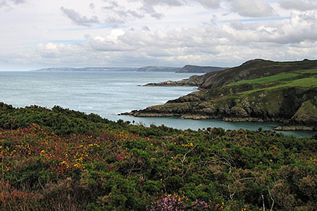
Turn west along the path. You soon reach Carregwastad Point where the French landed in 1797. A monument on the right-hand side of the path records this event. The onward undulating path is never in doubt with plenty of ups and downs as head west to Strumble Head. At several points along the path you walk close to the shore. The views ahead are generally good although it is worth stopping to look back with views extending into Carmarthenshire. Eventually you get your first sight of Strumble Head Lighthouse. Continue along the main path back to the start.
Maps 

| Ordnance Survey Explorer OL35 | Sheet Map | 1:25k | BUY |
| Anquet OS Explorer OL35 | Digital Map | 1:25k | BUY |
| Ordnance Survey Digital Map Subscription | |||
| Latest Ordnance Survey Discounts | |||
Other walks nearby
| Walk 3479 | Strumble Head & Garn Fawr Hillfort | moderate | 6.8 miles |
| Walk 3482 | Garn Fawr & Garn Fechan Hillforts | easy | 1.5 miles |
| Walk 3480 | Strumble Head from Garn Fawr | easy/mod | 5.0 miles |
| Walk 1434 | Abercastle & Trefin Circular | moderate | 7.5 miles |
| Walk 3474 | Dinas Island from Cwm-yr-Eglwys | easy | 3.0 miles |
| Walk 3477 | Porthgain, Abereiddi Bay & Blue Lagoon | easy | 3.7 miles |
| Walk 3476 | Porthgain & Blue Lagoon from Abereiddy | easy/mod | 6.5 miles |
| Walk 2291 | Mynydd Carningli from Newport | easy/mod | 4.5 miles |
| Walk 2056 | Pointz Castle from Solva | easy/mod | 5.5 miles |
| Walk 3466 | The Preseli Ridge along the Golden Road | moderate | 6.4 miles |
Recommended Books & eBooks
The Wales Coast Path
 A single guidebook to walking the whole Wales Coast Path - 1400km (870 miles) the length of Wales from Chester to Chepstow, including Anglesey, described in 57 stages. The route passes through the Snowdonia and Pembrokeshire National Parks and many AONBs and can be linked with the Offa's Dyke Path for a complete circuit of Wales.
More information
