Rolleston & Morton from Fiskerton
Nottinghamshire Walk
County/Area - Nottinghamshire
Author - Lou Johnson
Length - 6.3 miles / 10.2 km Ascent - 150 feet / 45 metres
Time - 3 hours 20 minutes Grade - easy
Walk Route Description
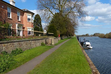
Click image to see photo description.
This Nottinghamshire walk starts from the attractive village of Fiskerton on the banks of the River Trent and explores the nearby villages of Rolleston and Morton. The route includes easy walking on clear paths between the villages and ends with a pleasant stroll along the banks of the River Trent following the Trent Valley Way.
The start is the small car park and picnic area on Rolleston Road about 500 metres east of Fiskerton (grid ref. SK742515) near the bridge over the River Greet. Exit the car park and turn left. Continue along the grass verge for 200 metres and take the signed footpath on the left. The path follows an embankment across fields. Continue straight ahead past Fiskerton Mill on your left and soon enter a large field. Go straight across the middle of this field to join an enclosed path which joins a lane (grid ref. SK744524). Turn left into Rolleston and follow the lane which bends left and then right.
Turn left into Station Road signed to Rolleston Station. Continue past the church and maybe pausing for refreshments at the vicarage tearooms. Continue along Station Road to reach the level crossing and Station (grid ref. SK737525). Immediately after the entrance to Southwell Racecourse, turn right into a field. Turn sharp left to follow the hedge (which is on your immediate left) and continue to reach the banks of Beck Dyke. Turn right along the Dyke to reach a lane (grid ref. SK727522). Turn left along the lane.
Immediately after the level crossing, turn right onto a track. Go through the metal gate and follow the path which parallels the railway on your right. After 700 metres the path reaches Causeway Lane (grid ref. SK724514). Turn left into Morton. Keep straight ahead into the centre of the village. Turn right into Main Street at a T-junction by the Full Moon Inn. After 400 metres the road forks. Bear right into Gorsy Lane and continue to just before Lodge Farm (on your right).
Turn left onto signed footpath opposite the farm. Initially you follow a tarmac drive. When this drive bends right, continue straight ahead with hedges on your left. Continue to follow the path which leads to a road (grid ref. SK729503). Go right and almost immediately left onto a track by a footpath sign. Reaching a way marker where the track bends left, continue ahead to the next marker post and walk right. The route soon bends left and then right before leading to you to the River Trent (grid ref. SK733495).
Turn left along the riverside path which is part of the Trent Valley Way. Continue following the river back into Fiskerton with its attractive waterfront where refreshments are usually available. Continue along the riverbank back to the start.
Maps 

| Ordnance Survey Explorer 271 | Sheet Map | 1:25k | BUY |
| Anquet OS Explorer 271 | Digital Map | 1:25k | BUY |
| Ordnance Survey Digital Map Subscription | |||
| Latest Ordnance Survey Discounts | |||
Other walks nearby
| Walk 1133 | Gunthorpe & Caythorpe from Hoveringham | easy/mod | 7.0 miles |
| Walk 2540 | The Robin Hood Way Long Distance Circular | mod/hard | 27.0 miles |
| Walk 3312 | Woolsthorpe and Stenwith | easy | 3.7 miles |
| Walk 2429 | Edwinstowe, Sherwood Forest & Major Oak circular | easy | 5.9 miles |
| Walk 1391 | Colston Bassett & Cropwell Bishop from Kinoulton | easy/mod | 8.5 miles |
| Walk 1431 | Haddington - Story of Two Churches | easy | 2.9 miles |
| Walk 2134 | Linby and Newstead Abbey circular | easy | 5.9 miles |
| Walk 1513 | Newstead Abbey from Linby | easy | 5.8 miles |
| Walk 1430 | Aubourn Country Circular | easy | 4.5 miles |
| Walk 1432 | Doddington circular | easy | 4.9 miles |
