Birkrigg Common and Bardsea
Cumbria Walk
County/Area - Cumbria - South Cumbria
Author - Ian Henderson
Length - 3.8 miles / 6.2 km Ascent - 500 feet / 152 metres
Time - 2 hours 20 minutes Grade - easy
Walk Route Description
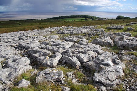
Click image to see photo description.
This South Cumbia walk on the Furness Peninsula, near Ulverston, explores an area of high ground known as Birkrigg Common which lies a mile or so inland from Ulverston Sands. The route includes the limestone pavements on the common where there are also several tumuli to investigate. Birkrigg Common also offers some fine views across Morecambe Bay, north to the Lake District National Park and west to the Yorkshire Dales.
To reach the start take the A5087 south from Ulverston. After approximately four kilometres, turn left down a minor road signed to Kingfisher Chemicals. Continue down the lane to reach a small car park on the sea front (grid ref. SD308746). After parking walk southwest along the beach for about a mile continuing parallel to the A5087 (on your right) for most of this section. Just after passing a row of boulders across the path, turn right to reach the A5087.
Go straight across to a lane which leads to Sunbrick, with a wall on your right. The lane climbs gently and after 450 metres take the path to the right onto the Common to visit the Neolithic Birkrigg stone circle. This consists of two concentric rings of stones dating from 1700-1400 BC.
To continue follow paths and tracks around the southern flank of Appleby Hill and onto the limestone paving of Birkrigg Common. This is the highest point on the Furness Peninsula at 136 metres. Take time to enjoy the expansive view which also includes the village of Great Unswick with its large tarn. Follow the track along the top of the limestone paving heading north to reach White Gill Lane (grid ref. SD287748).
Turn right down White Gill Lane to Bardsea. Reaching the main road through the village, turn right and then first left which leads back to the A5087. Go straight across and continue back to the start. Holy Trinity Church (Bardsea) is worth looking at particularly its wonderful position above Ulverston Sands. This can be reached by following the road into the village.
Maps 

| Ordnance Survey Explorer OL6 | Sheet Map | 1:25k | BUY |
| Anquet OS Explorer OL6 | Digital Map | 1:25k | BUY |
| Ordnance Survey Digital Map Subscription | |||
| Latest Ordnance Survey Discounts | |||
Other walks nearby
| Walk 3450 | Humphrey Head from Allithwaite | easy | 4.0 miles |
| Walk 2543 | Silverdale, Hawes Water & Jenny Brown's Point | easy | 7.0 miles |
| Walk 3656 | Hodbarrow Lagoon from Haverigg | easy | 4.2 miles |
| Walk 3234 | Gummers How via Chapel House Wood, South Lake District | easy/mod | 5.5 miles |
| Walk 1417 | Astley's Plantation & Simpson's Ground | easy/mod | 7.5 miles |
| Walk 2481 | Arnside Knott Circular | easy/mod | 6.0 miles |
| Walk 2511 | Silverdale & Arnside | easy/mod | 8.0 miles |
| Walk 1124 | Beacon Tarn & The Beacon from near Torver | easy/mod | 4.0 miles |
| Walk 1058 | Beacon Fell & Beacon Tarn Circular | easy/mod | 4.0 miles |
| Walk 3549 | Whitbarrow Scar from Mill Side | moderate | 6.5 miles |
Recommended Books & eBooks
Walking the Lake District Fells - Patterdale
 Part of the Walking the Lake District Fells series, this guidebook covers a wide range of routes to 35 Lakeland summits that can be climbed from Ambleside, Grasmere and Patterdale and the Thirlmere and Ullswater valleys, with highlights including Helvellyn and Fairfield. Suggestions for longer ridge routes are also included.
More information
The Cumbria Way
 A guidebook to the 73 mile Cumbria Way, an easy long-distance walk though the heart of the Lake District National Park, from Ulverston in the south to Carlisle in the north, with good transport links to either end. The route is largely low-level but this guide offers alternative mountain days to climb some of the famous fells en route.
More information
