The Black Lochs from Connel
Argyll and Bute Walk
County/Area - Argyll and Bute
Author - Charlotte Starkey
Length - 6.0 miles / 9.8 km Ascent - 750 feet / 227 metres
Time - 3 hours 50 minutes Grade - easy/mod
Walk Route Description
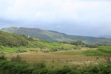
Click image to visit gallery of 6 images.
This is an easy walk amongst gentle valleys just outside of Oban. The outward route follows a minor road through the valley of Lusragan Burn. The return is on a good, clear path past the Black Lochs and offers good views of the nearby mountains, of which Ben Cruachan is prominent. Although undulating, there are no long or steep ascents, making it an ideal half day walk with children. The start is Connel Ferry station on the Glasgow to Oban line.
From the car park (grid ref. NM916340) at the railway station, you start by walking back down the lane to the village and then go left along the road to cross a small stream. As soon as you have crossed the stream, turn left on to a path. This path can be hard to spot in the summer when it is almost hidden by trees. The path takes you underneath a railway bridge and then through a metal gate before it starts to climb up a small hill.
You don't go very far along the path before you come to a narrow road which you turn left on to. After walking for ages along the road (Dad's GPS said it was 2.8km) you come to a house on the left with a rough track going back to the left. (GPS said this was at NM900312). To check you are at the right house, look for a white board that faces away from you but telling you this is the Black Lochs Path.
Go down the path, passing some farms and holiday cottages until you get to a bridge across a stream. This is a nice place to stop for something to eat and drink. We also had some fun seeing who could make the biggest splash throwing stones in to the stream.
A good path takes you round the side of a hill and then on to the start of the Black Lochs. Altogether there are 3 lochs but the water is hard to see in the first one because of all the long grass growing in the loch.
On this bit of the walk there are some big mountains in the background. With some help from dad, I used the map and compass to work out that the biggest of the mountains is Ben Cruachan.
When you get close to the third loch the path turns away to the left and takes you past some small farms before getting to a place called Achaleven. On the way to Achaleven you see the Connel Bridge that takes a road across Loch Etive.
When you get to a lane, turn left and follow the lane round the bend then under the railway bridge and down to the main road. Turn left on the road opposite Achaleven School then go left along the front of a hotel on a small road that takes you back in to the centre of Connel and the station.
Maps 

| Ordnance Survey Explorer 376 | Sheet Map | 1:25k | BUY |
| Anquet OS Explorer 376 | Digital Map | 1:25k | BUY |
| Ordnance Survey Digital Map Subscription | |||
| Latest Ordnance Survey Discounts | |||
Other walks nearby
| Walk 1606 | Ben Cruachan and Meall Cuanail | hard | 8.0 miles |
| Walk 3273 | Ben Starav | hard | 8.0 miles |
| Walk 1879 | Ben Starav & Glas Bheinn Mhor` | hard | 10.0 miles |
| Walk 3118 | Sgor na h'Ulaidh from Achnachon, Glen Coe | mod/hard | 8.0 miles |
| Walk 1162 | Pap of Glencoe | moderate | 4.2 miles |
| Walk 1234 | Pap of Glencoe (Route B) | moderate | 4.2 miles |
| Walk 3000 | Sgorr Nam Fiannaidh & Stob Coire Leith | hard | 6.2 miles |
| Walk 3322 | Sgurr na Ciche (Pap of Glencoe) | moderate | 4.2 miles |
| Walk 1161 | Beinn Resipol | hard | 9.0 miles |
| Walk 2955 | Ridges & peaks of Bidean Nam Bian | very hard | 10.5 miles |
