Walk 3729 - printer friendly version
Foreland Point Walk
Author - Lou Johnson
Length - 5.0 miles / 8.1 km
Ascent - 1200 feet / 364 metres
Grade - moderate
Start - OS grid reference SS753496
Lat 51.2319210 + Long -3.7874340
Postcode EX35 6NE (approx. location only)
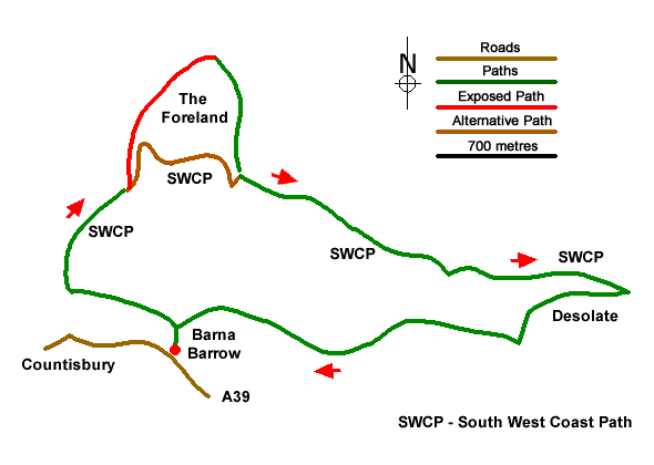
This North Devon walk in the Exmoor National Park starts from near Countisbury on the A39 east of Lynmouth. The route uses a section of the South West Coast Path to explore the coast from The Foreland to Desolation Point. The walk turns inland to return to the start across the moors. Note - one section of the walk uses a difficult section of path. An alternative route is explained below.
The start is the car park at Barna Barrow (grid ref. SS753496) which lies on the north side of the A39 about a kilometre east of Countisbury. After parking walk away from the main road towards the sea and bear right to follow a path with a wall on your left. After 500 metres you reach the point where the wall bends away to the left (grid ref. SS747499) and the South West Coast Path (SWCP). Turn right along the SWCP and descend across the steep flank of Butter Hill which rises on your right. After passing a bench there are some steep drops from the path so care is needed.
600 metres after leaving the wall you reach the head of a gulley (Great Red on OS maps) dropping steeply to the sea and a path junction (grid ref. SS750504). You now have a choice of routes.
Option 1 -the route of the GPS file bears left off the SWCP following a difficult path that descends steeply in places with some exposure on your left. This path leads down to the Foreland Point Lighthouse. Note that in wet or windy weather this path is hazardous and needs to be treated with extreme care. Reaching the shore continue east along the lighthouse access road to re-join the SWCP in Coddow Combe (grid ref. SS756505).
Option 2 - bear right and remain on the SWCP which follows an easier route down to the lighthouse access road in Coddow Combe (grid ref. SS756505). From here you can turn left and walk to Foreland Point before retracing your steps back to the SWCP in Coddow Combe. This is slightly longer than option 1 if you walk out to the lighthouse and back.
To continue the walk, follow the lighthouse access road from Coddow Combe in an easterly direction with the sea on your left. Where the road bends sharp right bear left off the road to continue along the SWCP. Follow the SWCP for two kilometres through woodland. Towards the end of this section the coast path climbs some steps to reach a path junction (grid ref. SS775498). Turn right signed to Countisbury. Continue up to the top of the rise to and turn right at a finger post (grid ref. SS770498).
Continue for 50 metres and turn left up to the driveway for Desolate Farm. Turn right along the farm drive and continue to a gate (grid ref. SS770496). Pass through the gate and turn right (signed to Countisbury). Follow the waymarked path across fields (fingerposts and yellow arrows) to pass Kipscombe Farm on your right. Continue on the waymarked path onto National Trust land, soon bearing left back to car park at Barna Barrow.
Messaging & Social Media
Message Walking Britain and follow the latest news.

Mountain Weather
Stay safe on the mountains with detailed weather forecasts - for iOS devices or for Android devices.