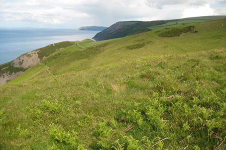
Foreland Point from Barna Barrow (Countisbury)
Exmoor Walk
Nat Park - Exmoor
County/Area - Devon
Author - Lou Johnson
Length - 5.0 miles / 8.1 km Ascent - 1200 feet / 364 metres
Time - 3 hours 40 minutes Grade - moderate
Walk Route Description
Click image to see photo description.
This North Devon walk in the Exmoor National Park starts from near Countisbury on the A39 east of Lynmouth. The route uses a section of the South West Coast Path to explore the coast from The Foreland to Desolation Point. The walk turns inland to return to the start across the moors. Note - one section of the walk uses a difficult section of path. An alternative route is explained below.
The start is the car park at Barna Barrow (grid ref. SS753496) which lies on the north side of the A39 about a kilometre east of Countisbury. After parking walk away from the main road towards the sea and bear right to follow a path with a wall on your left. After 500 metres you reach the point where the wall bends away to the left (grid ref. SS747499) and the South West Coast Path (SWCP). Turn right along the SWCP and descend across the steep flank of Butter Hill which rises on your right. After passing a bench there are some steep drops from the path so care is needed.
600 metres after leaving the wall you reach the head of a gulley (Great Red on OS maps) dropping steeply to the sea and a path junction (grid ref. SS750504). You now have a choice of routes.
Option 1 -the route of the GPS file bears left off the SWCP following a difficult path that descends steeply in places with some exposure on your left. This path leads down to the Foreland Point Lighthouse. Note that in wet or windy weather this path is hazardous and needs to be treated with extreme care. Reaching the shore continue east along the lighthouse access road to re-join the SWCP in Coddow Combe (grid ref. SS756505).
Option 2 - bear right and remain on the SWCP which follows an easier route down to the lighthouse access road in Coddow Combe (grid ref. SS756505). From here you can turn left and walk to Foreland Point before retracing your steps back to the SWCP in Coddow Combe. This is slightly longer than option 1 if you walk out to the lighthouse and back.
To continue the walk, follow the lighthouse access road from Coddow Combe in an easterly direction with the sea on your left. Where the road bends sharp right bear left off the road to continue along the SWCP. Follow the SWCP for two kilometres through woodland. Towards the end of this section the coast path climbs some steps to reach a path junction (grid ref. SS775498). Turn right signed to Countisbury. Continue up to the top of the rise to and turn right at a finger post (grid ref. SS770498).
Continue for 50 metres and turn left up to the driveway for Desolate Farm. Turn right along the farm drive and continue to a gate (grid ref. SS770496). Pass through the gate and turn right (signed to Countisbury). Follow the waymarked path across fields (fingerposts and yellow arrows) to pass Kipscombe Farm on your right. Continue on the waymarked path onto National Trust land, soon bearing left back to car park at Barna Barrow.
Maps 

| Ordnance Survey Explorer OL9 | Sheet Map | 1:25k | BUY |
| Anquet OS Explorer OL9 | Digital Map | 1:25k | BUY |
| Ordnance Survey Digital Map Subscription | |||
| Latest Ordnance Survey Discounts | |||
Other walks nearby
| Walk 1910 | Countisbury and Watersmeet from Lynmouth | easy/mod | 4.5 miles |
| Walk 3391 | Valley of Rocks frrom Lynton | easy/mod | 3.8 miles |
| Walk 1262 | Watersmeet & Foreland Point | mod/hard | 10.5 miles |
| Walk 1263 | The Doone Valley | moderate | 8.5 miles |
| Walk 3390 | Heddon Valley from Woody Bay | moderate | 5.3 miles |
| Walk 1727 | Shallowford, Hoar Oak Tree & The Chains | moderate | 11.7 miles |
| Walk 2387 | Pinkery Pond Circular | easy/mod | 5.8 miles |
| Walk 3386 | Barle Valley & Cow Castle from Simonsbath | easy/mod | 6.4 miles |
| Walk 3394 | Holdstone Down & Trentishoe | moderate | 7.0 miles |
| Walk 1221 | Selworthy Beacon & North Hill from Bossington | moderate | 8.5 miles |
Recommended Books & eBooks
The South West Coast Path
 Guidebook to walking the entire South West Coast Path National Trail. The route runs for 630 miles from Minehead to Poole along the north Devon, Cornish, south Devon and Dorset coastline. Divided into 45 stages, this long-distance coastal trek could be completed within 4 weeks, or walked in sections. Guide includes maps and essential information.
More information
South West Coast Path Map Booklet - St Ives to Plymouth
 Map of part of the southern section of the 630 mile (1014km) South West Coast Path National Trail. Covers the trail from St Ives to Plymouth along the west Cornwall and Devon coastline. This convenient and compact booklet of Ordnance Survey 1:25,000 maps shows the route, providing all of the mapping you need to walk the trail in either direction.
More information
