Walk 3743 - printer friendly version
Win Green from Tollard Royal Walk
Author - Lou Johnson
Length - 5.4 miles / 8.8 km
Ascent - 800 feet / 242 metres
Grade - easy/mod
Start - OS grid reference ST945178
Lat 50.9595980 + Long -2.0796840
Postcode SP5 5PW (approx. location only)
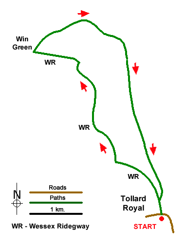
This circular walk explores the beautiful Wiltshire downs with its rolling hills and steep sided wooded valleys. Starting from the village of Tollard Royal the route initially follows the Wessex Ridgeway long distance footpath to reach Win Green with its outstanding views which include the Quantocks in Somerset and the Isle of Wight. The return follows a clear track back to the start.
The start is the small parking area in the centre of the village by a telephone box and opposite a pond on the north side of the B3081 (grid ref. ST945178). After parking turn right up the lane beside the parking area. After 100 metres the tarmac lane becomes a track (grid ref. ST944180). Take the left-hand fork to follow a grassy track up the valley with a steep grassy hillside rising on your right. You are now on the Wessex Ridgeway. After just over a kilometre your reach a junction of paths (grid ref. ST937187). Turn right and follow the path through the valley of Ashcombe Bottom.
After a further 800 metres you pass through a gate (grid ref. ST933192). Continue ahead following a chalk track. The route is generally clearly signed, and you continue for a further kilometre or so to reach a junction at the top of a short sharp section of uphill walking (ST930204). Turn left and continue uphill through trees to a small gate. Continue ahead over grassy downland with a fence on your left to a stile that gives access to Win Green (National Trust).
Once over the stile, bear right and continue to the trig point and topograph which are located just before a group of trees on Win Green. Allow time to enjoy the extensive view. To continue, walk to the trees and keeping them on your left locate a grassy path that descends to a gate (grid ref. ST927208). Stay on the chalky track for about 4 kilometres. Initially the track swings south across Berwick Down before descending back to the start.
Messaging & Social Media
Message Walking Britain and follow the latest news.

Mountain Weather
Stay safe on the mountains with detailed weather forecasts - for iOS devices or for Android devices.