Win Green from Tollard Royal
Wiltshire Walk
County/Area - Wiltshire
Author - Lou Johnson
Length - 5.4 miles / 8.8 km Ascent - 800 feet / 242 metres
Time - 3 hours 30 minutes Grade - easy/mod
Walk Route Description
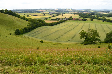
Click image to see photo description.
This circular walk explores the beautiful Wiltshire downs with its rolling hills and steep sided wooded valleys. Starting from the village of Tollard Royal the route initially follows the Wessex Ridgeway long distance footpath to reach Win Green with its outstanding views which include the Quantocks in Somerset and the Isle of Wight. The return follows a clear track back to the start.
The start is the small parking area in the centre of the village by a telephone box and opposite a pond on the north side of the B3081 (grid ref. ST945178). After parking turn right up the lane beside the parking area. After 100 metres the tarmac lane becomes a track (grid ref. ST944180). Take the left-hand fork to follow a grassy track up the valley with a steep grassy hillside rising on your right. You are now on the Wessex Ridgeway. After just over a kilometre your reach a junction of paths (grid ref. ST937187). Turn right and follow the path through the valley of Ashcombe Bottom.
After a further 800 metres you pass through a gate (grid ref. ST933192). Continue ahead following a chalk track. The route is generally clearly signed, and you continue for a further kilometre or so to reach a junction at the top of a short sharp section of uphill walking (ST930204). Turn left and continue uphill through trees to a small gate. Continue ahead over grassy downland with a fence on your left to a stile that gives access to Win Green (National Trust).
Once over the stile, bear right and continue to the trig point and topograph which are located just before a group of trees on Win Green. Allow time to enjoy the extensive view. To continue, walk to the trees and keeping them on your left locate a grassy path that descends to a gate (grid ref. ST927208). Stay on the chalky track for about 4 kilometres. Initially the track swings south across Berwick Down before descending back to the start.
Maps 

| Ordnance Survey Explorer 184 | Sheet Map | 1:25k | BUY |
| Anquet OS Explorer 184 | Digital Map | 1:25k | BUY |
| Ordnance Survey Digital Map Subscription | |||
| Latest Ordnance Survey Discounts | |||
Other walks nearby
| Walk 2448 | Ackling Dyke from Sixpenny Handley | easy/mod | 8.6 miles |
| Walk 3679 | Wardour Castle, Ansty Down & Wardour Park | easy/mod | 7.5 miles |
| Walk 3695 | Hambledon Hill & Hod Hill from Shroton | easy/mod | 6.0 miles |
| Walk 3237 | Bowerchalke & the Ox Drove | easy/mod | 8.0 miles |
| Walk 2171 | Knighton Hill & the Ox Drove | easy/mod | 5.8 miles |
| Walk 3626 | The Fovant Badges from Broad Chalke | easy/mod | 9.3 miles |
| Walk 2343 | Higher Pertwood & Wessex Ridgeway from Hindon | easy/mod | 8.1 miles |
| Walk 1748 | East Knoyle & Hindon from West Knoyle | moderate | 9.6 miles |
| Walk 3673 | Rawlsbury Camp, Lower Ansty, Hilton & Bulbarrow | easy/mod | 7.2 miles |
| Walk 2158 | Great Wishford & Grovely Lodge | easy/mod | 6.6 miles |
Recommended Books & eBooks
The Kennet and Avon Canal
 Guidebook to walking along the Kennet & Avon Canal. The 94 mile route from Reading to Bristol is split into 7 stages of fairly easy walking and includes the UNESCO World Heritage Site of Bath and Bristol's Floating Harbour. 20 circular walks are also included, ranging from 4¼ to 9 miles, taking in the best sections of the canal.
More information
