Houns-tout & Swyre Head from Kimmeridge
Jurassic Coast Walk
Region - Jurassic Coast
County/Area - Dorset
Author - Lou Johnson
Length - 8.7 miles / 14.1 km Ascent - 1100 feet / 333 metres
Time - 5 hours 30 minutes Grade - moderate
Walk Route Description
Click image to see photo description.
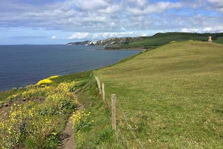
This Dorset walk from the village of Kimmeridge combines a beautiful section of the Jurassic Coast with a segment along an escarpment offering wide ranging views to the coast. The route uses well-signed paths and follows sections of the South West Coast Path and Hardy Way.
The start is the small car park located in a quarry above the village of Kimmeridge (Grid ref. SY918800). After parking exit the parking area and turn right. Turn left onto the path signed to Kimmeridge and descend past the church to the road in the village. Continue downhill towards the sea and follow the toll road down to its end and turn right past the toilets to join the South West Coast Path (grid ref. SY910788).
The onward route follows the coast path for five kilometres. Soon after joining the coast path, you pass the Clavell Tower. Initially the path is undulating but nearing Houns-tout cliff there is a steep ascent onto the cliff top. Reaching a stone seat (grid ref. SY950773) turn left over a stile towards Kingston. Initially the path crosses farmland along the edge of the escarpment. As you near Kingston the path passes through pleasant woodland (The Plantation) to reach Houns-tout car park and a lane (grid ref. SY954800).
Turn left along the lane and continue to the next car park (grid ref. SY943793). Turn left and follow a clear track across the downs to reach Swyre Head with its trig column and superb panoramic view along the coast. Turn sharp right through a gate and continue along the escarpment for three kilometres back to the start enjoying excellent views for much of the way.
Maps 

| Ordnance Survey Explorer OL15 | Sheet Map | 1:25k | BUY |
| Anquet OS Explorer OL15 | Digital Map | 1:25k | BUY |
| Ordnance Survey Digital Map Subscription | |||
| Latest Ordnance Survey Discounts | |||
Other walks nearby
| Walk 2145 | Houns-tout Cliff from Kingston | easy | 3.5 miles |
| Walk 2568 | Egmont Point & Kimmeridge Bay from Tyneham | moderate | 14.0 miles |
| Walk 1533 | Gad Cliff, Povington Hill & Tyneham | easy/mod | 4.5 miles |
| Walk 2925 | St Aldhelm's Head near Worth Matravers | easy | 4.1 miles |
| Walk 3286 | Dancing Ledge & Durlston Head from Langton Matravers | easy/mod | 7.0 miles |
| Walk 1004 | Durdle Door & Lulworth Cove | easy | 2.5 miles |
| Walk 1329 | Durdle Door & White Nothe from Lulworth Cove | moderate | 7.0 miles |
| Walk 3389 | Bindon Hill and the Fossil Forest from Lulworth | easy/mod | 4.0 miles |
| Walk 2579 | Purbeck Coast from Swanage | moderate | 10.0 miles |
| Walk 1634 | Old Harry & Ballard Down from Studland | easy/mod | 5.3 miles |
Recommended Books & eBooks
The South West Coast Path
 Guidebook to walking the entire South West Coast Path National Trail. The route runs for 630 miles from Minehead to Poole along the north Devon, Cornish, south Devon and Dorset coastline. Divided into 45 stages, this long-distance coastal trek could be completed within 4 weeks, or walked in sections. Guide includes maps and essential information.
More information
South West Coast Path Map Booklet - Minehead to St Ives
 Map of the northern section of the 630 mile (1014km) South West Coast Path National Trail. Covers the trail from Minehead to St Ives along the north Devon and Cornish coastline. This convenient and compact booklet of Ordnance Survey 1:25,000 maps shows the route, providing all of the mapping you need to walk the trail in either direction.
More information
