Ripponden and the Calderdale Way
West Yorkshire Walk
County/Area - West Yorkshire - Calderdale
Author - Allan Friswell
Length - 6.5 miles / 10.6 km Ascent - 900 feet / 273 metres
Time - 4 hours 10 minutes Grade - easy/mod
Walk Route Description

Click image to visit gallery of 6 images.
This Calderdale walk is a straightforward one to follow, combining large sections of the very well signed Calderdale Way with tarmacked lanes across moorland and clear paths through deciduous woods. As ever in Calderdale there is both plenty of water and climbing, though the climbs are long and gentle rather than exhausting. There are many opportunities to stop and take in the views!
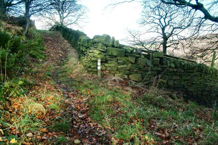
From the Royd Lane car park (Grid ref. SE040199) climb the road to find the Calderdale Way on the right after about 50 yards. Follow this along a pleasant narrow walled track at the end of which the route bears left (now a bridleway). Keep following the left-hand wall, finally reaching a squeeze stile in a corner where you turn left to follow the walled and in places setted lane. When you reach the hamlet of Soyland turn right and after about 200 yards take the CW waymarked flagged path on the right. At the end of this turn right again along the track; after about 150 yards you take the path on the left (still the CW). Follow this steeply downhill, emerging through a small gate on to Clapgate Lane. A left and then right drops you into the delightful village of Mill Bank. In 1970 Sowerby Bridge Council proposed demolishing these lovely seventeenth century buildings, so typical of Calderdale in their architecture. Locals successfully fought this barbarism.
At the Lumb Brook and bridge take the CW on the left and follow it along the edge of Great House Wood, following a line defining the conifers on the left and the deciduous trees on the right. You pass a pretty ornamental lake below you. At a tarmacked lane turn right - this soon becomes more of a grass and tarmac track. Soon you reach a post on the right which formerly bore the CW sign (Grid ref. SE031210) and you follow the track along for a third of a mile, arriving at Lighthazles Road, where you cross and walk up the wonderfully named Eccles Parlour. For the next mile you simply follow the winding tarmac, ignoring all footpath temptations either side and, where the road branches, following it left.
You finally arrive at moorland on your right and the road narrows but remains tarmacked - continue along it (Coal Gate Road) for another mile. There are superb views across to your left towards Mill Bank and Ripponden Wood. There are several memorial benches along this stretch to allow you to enjoy these. Shortly after passing the third (white) private wind turbine take the signed bridleway on the left (Flight House Road) to its end. Turn right then left along Ripponden Old Lane. Ignore the first path down via the farm - take the second after about 200 yards, descending to the beautifully setted Great House Lane. Go right and then take the path running obscurely down the side of the bungalow's garage on the left. It brings you to bus-stops on the A58.
Turn left. After a few yards cross and follow the path down the field, hugging the wall, and once over the stile go left along the obvious track, then right after the first dwelling, crossing a small parking area and dropping down through stiles to the dam of Ryburn Reservoir. Keep the beck on your right as you walk through the woodland, following the track, bearing left at one point, eventually arriving at the A672 Oldham Road and more bus-stops! Go left along this road for a quarter of a mile, crossing to the Silk Mill pub and dropping down the path on its left to the river. Cross the metal bridge, and then follow the Ryburn left back to Ripponden. There go under the bridge, climb, turn left on to Old Bank and walk back over another bridge, passing a pub and then climbing the final setted Priest Lane to the Rochdale Road, with Royd Lane and the car park opposite.
Maps 

| Ordnance Survey Explorer OL21 | Sheet Map | 1:25k | BUY |
| Anquet OS Explorer OL21 | Digital Map | 1:25k | BUY |
| Ordnance Survey Digital Map Subscription | |||
| Latest Ordnance Survey Discounts | |||
Other walks nearby
| Walk 1587 | Scammonden Reservoir | easy | 4.0 miles |
| Walk 1336 | Sowerby Bridge and Norland Moor | easy/mod | 7.0 miles |
| Walk 1626 | Luddenden Foot Circular | easy/mod | 7.5 miles |
| Walk 1057 | Luddenden Dean and the Calderdale Way | easy/mod | 6.5 miles |
| Walk 1849 | Blackstone Edge and the Pennine Way without a car | moderate | 8.0 miles |
| Walk 2260 | White Hill from Hollingworth Lake | moderate | 11.2 miles |
| Walk 1041 | Halifax - the Magna Via and Southowram | easy/mod | 5.5 miles |
| Walk 2359 | Cuckoo Walk & Bacon Butties from Marsden | hard | 19.5 miles |
| Walk 2644 | Marsden and the Standedge Trail | moderate | 11.0 miles |
| Walk 2926 | Cupwith & Shooter's Nab from Marsden | moderate | 13.0 miles |

