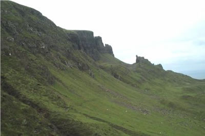
The Quirang from Bealach Ollasgairte
Highland Walk
County/Area - Highland - Isle of Skye
Author - Lou Johnson
Length - 3.2 miles / 5.2 km Ascent - 1100 feet / 333 metres
Time - 2 hours 40 minutes Grade - easy
Walk Route Description
Click image to visit gallery of 3 images.
A short but enjoyable walk but rather more challenging than a first glance would suggest. The place to start (probably along with many other people) is the parking area at Bealach Ollasgairte where the Staffin to Uig road breaches the Trotternish escarpment. This bealach is not named on the OS Landranger Map but can be found at grid reference NG440679. Alternatively you can start the walk from the car park at the nearby cemetery (grid ref. NG446680) although this involves an additional 350 feet (100 metres) of ascent. Whichever way you chose the scenery is wonderful with sheer cliffs dominating the grassy lower slopes of the escarpment.
The scenery of the east facing Trotternish escarpment is outstanding without the added bonus of the Storr Sanctuary and the Quirang. This short expedition provides intimate views of the escarpment as well as allowing you to see at close quarters the three principal elements of the Quirang - The Needle, The Prison and The Table. From the road take the level path which contours along the base of the cliffs to your left. The going is generally easy although there is an awkward stream to cross together with a steep ascent over grass to reach the Table.
The Prison is the first large rocky prominence reached on your right. Further along The Needle soars skyward on your left. By climbing up the steep grassy slope behind The Needle you will reach The Table, the top of which can be gained after a scramble up a short gully. Despite the modest elevation, the views are wide ranging with your eyes drawn to the many fascinating sights both near and far. After allowing suitable time for exploration you return to your transport by the outward route. However try to have some spare time and head further north along the main path beyond The Needle. Suddenly the crowds disappear and you can enjoy the delights of the Trotternish escarpment in solitude extending your walk as far as you wish.
Maps 

| Ordnance Survey Explorer 408 | Sheet Map | 1:25k | BUY |
| Anquet OS Explorer 408 | Digital Map | 1:25k | BUY |
| Ordnance Survey Digital Map Subscription | |||
| Latest Ordnance Survey Discounts | |||
Other walks nearby
| Walk 1164 | The Storr Sanctuary | easy/mod | 3.2 miles |
| Walk 2640 | The Storr & Old Man of Storr | moderate | 5.5 miles |
| Walk 2002 | Dun Caan, Isle of Raasay | moderate | 10.6 miles |
| Walk 1566 | Isle of Scalpay circular, Harris | easy | 5.3 miles |
| Walk 3760 | Glamaig (Sgurr Mhairi & An Coileach) | mod/hard | 4.5 miles |
| Walk 2589 | Marsco | moderate | 8.7 miles |
| Walk 1621 | Urgha Beag Circular from near Tarbert | moderate | 11.8 miles |
| Walk 1344 | Beinn Alligin & Sgurr Mor | mod/hard | 6.0 miles |
| Walk 3216 | Sgurr a'Ghreadaidh and Sgurr na Banachdich | very hard | 5.5 miles |
| Walk 2442 | An Cliseam, Isle of Harris | moderate | 3.0 miles |
Recommended Books & eBooks
Walking in Torridon
 This guidebook contains 52 day walks in Torridon, a remote and much-loved area of the Scottish Highlands. Based around Shieldaig and Slioch, the routes are split into 3 sections: easy walks, long and high level walks and mountain ascents over 2000ft including 9 Munros, and 5 outline suggestions for major ridge walks.
More information
Walking the Munros Vol 2 - Northern Highlands and the Cairngorms
 Guidebook to walking the northern Munros, covering the northern Highlands, the Cairngorms and the Isle of Skye. 70 routes are described, including those up Ben Macdui, Braeriach and Cairn Gorm. Routes range from 7 to 46km, requiring a fair level of fitness. The second of two guidebooks to walking Scotland's Munros: peaks higher than 3000ft.
More information
