Marsco from Sligachan Hotel
Highland Walk
County/Area - Highland - Isle of Skye
Author - Paul Gasson
Length - 8.7 miles / 14.1 km Ascent - 2500 feet / 758 metres
Time - 6 hours 50 minutes Grade - moderate
Walk Route Description
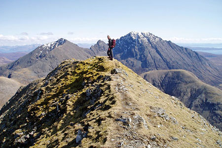
Click image to see photo description.
The start of the walk is at the Sligachan Hotel (Grid ref. NG485299), on the A87, more or less half way between Broadford and the island's capital of Portree.
Close to the old bridge across the Sligachan River a signpost indicates Loch Coruisk. Take this clear, rough path for some 2 miles along the magnificent Glen Sligachan, crossing numerous small streams, until you come to a river, the Allt na Measarroch, and the remains of an old deer fence. This is the March Fence marking the limit of Lord MacDonald's forest.
Leave the Coruisk path here, turning east and then southeast to follow the burn across the moor, avoiding, if you can, the boggier parts. Climbing slowly, a shallow ravine is reached, from where a steep pull up brings you to the col, Mam a Phobuill, between Marsco and the Beinn Dearg tops. This is a good spot to admire the views across Glen Sligachan to Sgurr nan Gillean, the most pinnacled peak in Scotland, and in the opposite direction, to the mainland.
The climb now begins in earnest, with a faint path following the line of the dilapidated deer fence southwards up to the ridge. As you breast the ridge you are met by an almost overwhelming spectacle! To your left, across the Am Fraoch-choire lies the rocky outlier of Ruadh Stac, with, behind it, the magnificence of Blaven, the dramatic, jagged ridge of Clach Glas, Garbh Beinn and Belig. Straight ahead are the southern peaks of the Main Cuillin Ridge, with Sgurr Alisdair and Sgurr Thearlaich prominent in the centre. Far below are the diminutive Dubh Lochs in Glen Sligachan, and, a little further South, Loch Creitheach and Camasunary.
From here, easy angled slopes lead up to the true summit ridge, a short but knife edged ridge akin to walking along the ridge of a house, with the valley floor 2000ft. below, leading to the tiny summit at 2,412ft. The views in every direction are magnificent, and this is a good spot to try and spot a Golden Eagle soaring high over the glen.
When the time comes to head home, do not be tempted to continue northwest along a broad, easy angled ridge. This leads to dangerously steep ground and crags. Return the way you came up, though an alternative is to descend into Coire nan Laogh from the point where you crested the ridge, then regain your outward path below the col.
Make your way back along the glen to the Sligachan Hotel, where you can enjoy a well earned drink in the welcoming bar and reflect on a memorable walk in magnificent surroundings.
Maps 

| Ordnance Survey Explorer 411 | Sheet Map | 1:25k | BUY |
| Anquet OS Explorer 411 | Digital Map | 1:25k | BUY |
| Ordnance Survey Digital Map Subscription | |||
| Latest Ordnance Survey Discounts | |||
Other walks nearby
| Walk 3760 | Glamaig (Sgurr Mhairi & An Coileach) | mod/hard | 4.5 miles |
| Walk 2002 | Dun Caan, Isle of Raasay | moderate | 10.6 miles |
| Walk 3216 | Sgurr a'Ghreadaidh and Sgurr na Banachdich | very hard | 5.5 miles |
| Walk 2197 | The Inaccessible Pinnacle and Sgurr Mhic Choinnich | very hard | 6.0 miles |
| Walk 1167 | Glen Brittle & Coire Lagan | moderate | 4.6 miles |
| Walk 3753 | Blabheinn via south ridge | mod/hard | 8.0 miles |
| Walk 1166 | Loch Coruisk | easy | 4.0 miles |
| Walk 1164 | The Storr Sanctuary | easy/mod | 3.2 miles |
| Walk 2640 | The Storr & Old Man of Storr | moderate | 5.5 miles |
| Walk 1886 | Carn a' Bhealaich Mhoir | easy/mod | 8.0 miles |
Recommended Books & eBooks
Great Mountain Days in Scotland
 Inspirational guidebook to 50 challenging routes for mountaineers, scramblers, hillwalkers and fell runners, many long enough to backpack over 2 days, especially in winter (12 to 25 miles). A mix of classic routes and unsung gems across Scotland from Galloway to the Outer Hebrides in widely differing wild landscapes. With customised OS mapping.
More information
Walking the Munros Vol 2 - Northern Highlands and the Cairngorms
 Guidebook to walking the northern Munros, covering the northern Highlands, the Cairngorms and the Isle of Skye. 70 routes are described, including those up Ben Macdui, Braeriach and Cairn Gorm. Routes range from 7 to 46km, requiring a fair level of fitness. The second of two guidebooks to walking Scotland's Munros: peaks higher than 3000ft.
More information
