Porth Clais & St Justinian's
Pembrokeshire Coast Walk
Nat Park - Pembrokeshire Coast
County/Area - Pembrokeshire
Author - Lou Johnson
Length - 5.5 miles / 8.9 km Ascent - 525 feet / 159 metres
Time - 3 hours 20 minutes Grade - easy/mod
Maps 

| Ordnance Survey Explorer OL35 | Sheet Map | 1:25k | BUY |
| Anquet OS Explorer OL35 | Digital Map | 1:25k | BUY |
| Ordnance Survey Landranger 157 | Sheet Map | 1:50k | BUY |
| Anquet OS Landranger 157 | Digital Map | 1:50k | BUY |
Walk Route Description
Click image to visit gallery of 4 images.
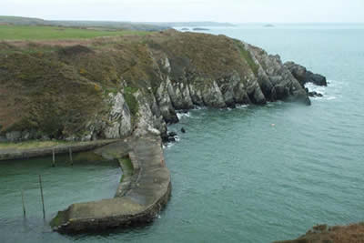
The Pembrokeshire Coast National Park despite its small size has plenty to offer walkers. The coastline is varied and this particular walk takes in one of the more rugged sections. Nowhere is this route strenuous but it does offer the opportunity to feel close to the sea and rocks. In addition there is a good chance you will see some interesting birds together with the opportunity to see some seals.
The start is in the small car park at Porth Clais (grid ref. SM741241). During the peak months there is a small charge. From the car park walk towards the small harbour and keep on the right hand side taking the signed coast path.
The onward route is straightforward staying close to the top of the cliffs for the section through to St Justinian's where there is a lifeboat station. The path is easy to follow and there are only a few ups and downs. The views are on the seaward side with interesting cliffs complete with caves and arches. Quite soon after leaving Porth Clais you can see the rocks of Ramsey Island, which lies just over a mile off shore. This sparsely inhabited island can be visited and looks as though it provides some excellent walks.
Like many coastal walks there are a few sections where a slip could end in personal disaster but assuming you have safely negotiated these dangers you will arrive at St Justinian's where the corrugated lifeboat station contains an immaculately maintained vessel. Admission to the station is by donation. Ahead, further along the coast lie two fine looking hills, one with a good ridge. These can easily be included by extending the walk.
Take the lane heading inland and follow it past Rhosson farm. To your right is a reedy pool - Pwll Trefeiddan - and after this turn right at a junction. This lane leads down to Clegyr-Boia and on past Rhos y-cribed farm to reach the car park at Porth Clais.
Other walks nearby
| Walk 1997 | St. David's & Coast Path Circular | moderate | 9.7 miles |
| Walk 2057 | St. David's Head & Carn Llidi | easy/mod | 4.5 miles |
| Walk 3483 | Penberry & St Davids Head from Whitesands Bay | moderate | 9.0 miles |
| Walk 2056 | Pointz Castle from Solva | easy/mod | 5.5 miles |
| Walk 3476 | Porthgain & Blue Lagoon from Abereiddy | easy/mod | 6.5 miles |
| Walk 3477 | Porthgain, Abereiddi Bay & Blue Lagoon | easy | 3.7 miles |
| Walk 1434 | Abercastle & Trefin Circular | moderate | 7.5 miles |
| Walk 2485 | Broad Haven & Druidston Circular | easy/mod | 4.9 miles |
| Walk 3473 | Marloes Peninsular Circular | easy/mod | 7.0 miles |
| Walk 3362 | Marloes Sands Circular | easy | 4.5 miles |
Recommended Books & eBooks
The Wales Coast Path
 A single guidebook to walking the whole Wales Coast Path - 1400km (870 miles) the length of Wales from Chester to Chepstow, including Anglesey, described in 57 stages. The route passes through the Snowdonia and Pembrokeshire National Parks and many AONBs and can be linked with the Offa's Dyke Path for a complete circuit of Wales.
More information
Messaging & Social Media
Message Walking Britain and follow the latest news.

Mountain Weather
Stay safe on the mountains with detailed weather forecasts - for iOS devices or for Android devices.