Marloes Sands Circular
Pembrokeshire Coast Walk
Nat Park - Pembrokeshire Coast
County/Area - Pembrokeshire
Author - Lou Johnson
Length - 4.5 miles / 7.3 km Ascent - 500 feet / 152 metres
Time - 2 hours 50 minutes Grade - easy
Walk Route Description
Click image to see photo description.
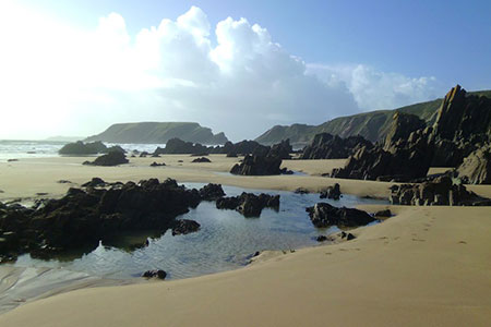
A Pembrokeshire walk exploring the beautiful section of coastline above Marloes Sands. The route follows the Pembrokeshire Coast Path for part of the way and offers extensive views along the beach, passes the Raggle Rocks, Gateholm Island and the adjacent rock stack and ends with a view to Skomer Island.
The start is the National Trust car park close to Marloes Mere (grid ref. SM779082). After parking exit the car park onto the lane. Continue along the lane ignoring the footpath on the right. You soon pass Marloes Court Farm on your right. Just over half a kilometre beyond the farm, turn right down a lane (grid ref. SM792082) which is signed as a no through road. Continue for 800 metres to just before Little Marloes Farm. Where the lane bears right towards the farm, continue ahead with a hedge on your right. Follow this path to reach a wide concrete 'runway' which is part of the former airfield.
Turn half right, and then follow the old taxiway round to the south. The path continues to pass through a gate in a fence (grid ref. SM791069). After the fence, bear half right over concrete to reach the Pembrokeshire Coast Path. Turn right and continue along the clear clifftop path with the sea on your left. You soon pass through a gate with a great view along Marloes Sands to Gateholm Island. The onward path is easy to follow and never demanding. You pass through two gates, after which a fingerpost on the left indicates a path down to the beach which is a pleasant optional diversion.
Reaching another gate, you descend some steps after which you can drop down to the beach on your left. A short climb takes you back to the clifftop with Raggle Rocks below on the beach. Ahead you can enjoy the view to Gateholm Island. Another short climb leads you past the remains of Gateholm Stack and a gate and three-way fingerpost on the right. Ignore this path and continue along the coast path. Stockholm Island comes into view and shortly after you pass through another gate with Skomer Island now in view ahead. Reaching a gate and fingerpost on the right (grid ref. SM770079), turn right through the gate and follow the fence (on your left) around the edge of the field. The path then leads to an enclosed track which improves as you pass Runwayskiln restaurant on your right to reach the road. Turn left to the car park used at the start of the walk.
Maps 

| Ordnance Survey Explorer OL36 | Sheet Map | 1:25k | BUY |
| Anquet OS Explorer OL36 | Digital Map | 1:25k | BUY |
| Ordnance Survey Digital Map Subscription | |||
| Latest Ordnance Survey Discounts | |||
Other walks nearby
| Walk 3496 | St Anne's Head & Dale Peninsula | easy/mod | 7.0 miles |
| Walk 3497 | Angle Peninsula | easy | 3.7 miles |
| Walk 2485 | Broad Haven & Druidston Circular | easy/mod | 4.9 miles |
| Walk 3498 | Freshwater West & Angle | moderate | 8.7 miles |
| Walk 1210 | Porth Clais & St Justinian's | easy/mod | 5.5 miles |
| Walk 2056 | Pointz Castle from Solva | easy/mod | 5.5 miles |
| Walk 1997 | St. David's & Coast Path Circular | moderate | 9.7 miles |
| Walk 2057 | St. David's Head & Carn Llidi | easy/mod | 4.5 miles |
| Walk 3483 | Penberry & St Davids Head from Whitesands Bay | moderate | 9.0 miles |
| Walk 3476 | Porthgain & Blue Lagoon from Abereiddy | easy/mod | 6.5 miles |
Recommended Books & eBooks
The Wales Coast Path
 A single guidebook to walking the whole Wales Coast Path - 1400km (870 miles) the length of Wales from Chester to Chepstow, including Anglesey, described in 57 stages. The route passes through the Snowdonia and Pembrokeshire National Parks and many AONBs and can be linked with the Offa's Dyke Path for a complete circuit of Wales.
More information
