Calton and Hanlith Moors from Airton
Yorkshire Dales Walk
Nat Park - Yorkshire Dales - Malhamdale
County/Area - North Yorkshire
Author - Allan Friswell
Length - 6.5 miles / 10.6 km Ascent - 600 feet / 182 metres
Time - 3 hours 50 minutes Grade - easy/mod
Maps 

| Ordnance Survey Explorer OL30 | Sheet Map | 1:25k | BUY |
| Anquet OS Explorer OL30 | Digital Map | 1:25k | BUY |
| Ordnance Survey Landranger 98 | Sheet Map | 1:50k | BUY |
| Anquet OS Landranger 98 | Digital Map | 1:50k | BUY |
Walk Route Description
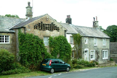
Click image to visit gallery of 9 images.
A straightforward Yorkshire Dales walk in Malhamdale from the delightful village of Airton. The route covers grass meadows and lonely peat moorland, with a final leg along the pretty river Aire via the Pennine Way.
From the picturesque triangular village green at Airton (grid ref. SD 902 591) walk downhill away from the road towards the river. Cross the bridge with its fine view of the old mills and climb through the hamlet of Calton. Where the road turns right for Winterburn keep ahead along the lane, then the track which brings you to a gate and sign to Weets Top. Follow the hairpin track and bear right to a gate. From here the path is not clear, but you need to keep at about 75 yards from the left hand wall to reach the gate in the far distant wall ahead, near the field's corner (grid ref. SD915605).
The next 2.5 miles are over access land, a clear track proceeding for 1.5 of these over the tranquil peat moors to where a signpost at the top of a rise signals you to go left. Pass through the gate, and initially keep fairly close to the wall on the right, eventually espying the track to your left after about 100 yards. Even if you fail to find this, you simply descend keeping fairly close to the wall, carefully negotiating several boggy areas (easier than they look) and following the wall as it curves left, eventually ending at the obvious gate and walled track that is Windy Pike Lane. (grid ref. SD914619)
Follow this down for a mile into Hanlith. Over to your right is the range of hills in which both Malham Cove and Gordale Scar about a mile to its right are clearly visible. Shortly after passing the splendid Hanlith Hall you reach the bridge over the river. Go through its stone stile and follow the Pennine Way for just over a mile along the Aire. On the outskirts of Airton you will see two footbridges on opposite sides of the field - you take the right hand one, climb the gravel track, turn left along the Malham road and walk back to the green.
Other walks nearby
| Walk 2385 | Airton & Bell Busk Circular | easy/mod | 6.8 miles |
| Walk 2066 | Winterburn Reservoir circular | easy | 6.0 miles |
| Walk 1051 | Gordale Scar & Malham Cove (Route 2) | moderate | 7.0 miles |
| Walk 1239 | Gordale Scar & Malham Cove | easy/mod | 6.5 miles |
| Walk 1274 | Nappa Cross & Malham | easy/mod | 5.5 miles |
| Walk 2602 | Gordale Scar & Malham Cove (Route 3) | moderate | 9.1 miles |
| Walk 2704 | Kirkby Malham & Hanlith from Malham | easy | 4.0 miles |
| Walk 2737 | The River Aire & Kirkby Malham from Malham | easy | 3.0 miles |
| Walk 3577 | Malham Cove from Malham | easy | 3.0 miles |
| Walk 3107 | Flasby Fell from Flasby | easy/mod | 6.5 miles |
Recommended Books & eBooks
Walking in the Yorkshire Dales: South and West
 Part of a two-book set, this guidebook describes 44 walks in the southern and western Yorkshire Dales, including the famous 23 mile Three Peaks circuit over Pen-y-Ghent, Whernside and Ingleborough. The other, mostly circular routes of 3½ to 13 miles cover the scenic region between Sedbergh, Kirkby Lonsdale, Settle, Skipton and Grassington.
More information
Pennine Way Map Booklet
 Map of the 270 miles (435km) Pennine Way National Trail, between Edale in the Peak District and Kirk Yetholm in the Scottish Borders. This booklet is included with the Cicerone guidebook to the trail, and shows the full route on Ordnance Survey 1:25,000 maps. This popular long-distance route typically takes three weeks to complete.
More information
Messaging & Social Media
Message Walking Britain and follow the latest news.

Mountain Weather
Stay safe on the mountains with detailed weather forecasts - for iOS devices or for Android devices.