Attermire Scar and Catrigg Force from Settle
Yorkshire Dales Walk
Nat Park - Yorkshire Dales - Lower Ribblesdale
County/Area - North Yorkshire
Author - Lou Johnson
Length - 6.5 miles / 10.6 km Ascent - 1400 feet / 424 metres
Time - 4 hours 40 minutes Grade - easy/mod
Maps 

| Ordnance Survey Explorer OL2 | Sheet Map | 1:25k | BUY |
| Anquet OS Explorer OL2 | Digital Map | 1:25k | BUY |
| Ordnance Survey Landranger 98 | Sheet Map | 1:50k | BUY |
| Anquet OS Landranger 98 | Digital Map | 1:50k | BUY |
Walk Route Description
Click image to visit gallery of 6 images.
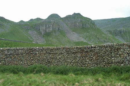
This Yorkshire Dales walk explores the magnificent limestone scenery that is found is this part of the Yorkshire Dales National Park. The start is the small market town of Settle, which is worthy of further exploration either before you start the walk or at the end. Like all market towns of this size, Settle has an assortment of shops, cafés and pubs together with a Tourist Information Centre.
After parking, walk towards the town centre and locate the Market Place (Grid ref. SD819637). Take Constitution Hill which climbs steeply and turns sharp left. Just after this bend take the track on the right (Grid ref. SD821637). Follow this track as climbs further up the hillside. The path starts to level off and you reach a path junction (Grid ref. SD822641). Turn right here and continue the climb soon entering a very interesting limestone landscape with Sugar Loaf Hill rising on your right.
The path descends to reach a cross path (Grid ref. SD838641). From here you can walk ahead and visit Attermire Cave, which is visible ahead, or more likely turn left and follow the path north through the limestone of Attermire Scar to pass below Victoria Cave, which again can be visited by taking a short diversion. A short way ahead you join a track coming in from the left and pass the twin entrances to Jubilee Caves. These can be explored but do be careful.
To continue retrace you steps a short way and cross the stile (Grid ref. SD837654) passed a short while ago that leads onto a path heading northwest. This path crosses another stile into a field and then exits onto a road by a cattle grid. Turn right along this road. Ignore the access drive to Winskill and continue to the next track on your left (Grid ref. SD839664). Take this track and follow it down hill. Bear right at the bottom (Grid ref. SD832668) and continue a short way further to reach a signed footpath on your right. This leads down to Catrigg Force.
Retrace you steps up the path to the track. Turn left and then turn right towards Upper Winskill. Do not turn into Upper Winskill but continue on the track towards Lower Winskill. Before reaching the latter, take the signed footpath on your right to Langcliffe. This leads downhill through fields to join a walled lane that takes you into the centre of Langcliffe Village.
Bear left onto the main lane leading through the village and go past the church. Turn right off this lane onto a signed bridleway to Settle. Initially you climb steeply. After making a right turn the way ahead levels off as you contour across the hillside towards Settle. Passing the path you used earlier in the day, the track descends into Settle. Continue down Constitution Hill to Settle Market Place and the end of the walk.
Other walks nearby
| Walk 2082 | Attermire Scar, Catrigg Force & Langcliffe | easy/mod | 7.5 miles |
| Walk 2603 | Feizor & Giggleswick Scar from Settle | easy/mod | 8.0 miles |
| Walk 2617 | Nappa Cross & Victoria Cave from Langcliffe | moderate | 9.5 miles |
| Walk 1404 | Oxenber and Wharfe Woods from Langcliffe | moderate | 10.5 miles |
| Walk 2649 | Attermire Scar & Malham Tarn from Stainforth | mod/hard | 16.5 miles |
| Walk 1251 | The Norber Erratics & Sulber Gate | moderate | 8.0 miles |
| Walk 2620 | Sulber Gate & Crummack Dale from Austwick | moderate | 9.5 miles |
| Walk 3092 | Malham Cove, Malham Tarn & Watlowes | easy | 4.4 miles |
| Walk 1051 | Gordale Scar & Malham Cove (Route 2) | moderate | 7.0 miles |
| Walk 1239 | Gordale Scar & Malham Cove | easy/mod | 6.5 miles |
Recommended Books & eBooks
Walking in the Yorkshire Dales: South and West
 Part of a two-book set, this guidebook describes 44 walks in the southern and western Yorkshire Dales, including the famous 23 mile Three Peaks circuit over Pen-y-Ghent, Whernside and Ingleborough. The other, mostly circular routes of 3½ to 13 miles cover the scenic region between Sedbergh, Kirkby Lonsdale, Settle, Skipton and Grassington.
More information
Trail and Fell Running in the Yorkshire Dales
 Guidebook to 40 of the best trail and fell runs in the Yorkshire Dales National Park. Ranging from 5 to 24 miles, the graded runs start from bases such as Ribblehead, Dent, Sedbergh, Malham and Grassington and take in the region's diverse delights, from castles and waterfalls to iconic mountains such as Whernside, Ingleborough and Pen Y Ghent.
More information
Messaging & Social Media
Message Walking Britain and follow the latest news.

Mountain Weather
Stay safe on the mountains with detailed weather forecasts - for iOS devices or for Android devices.