Feizor & Giggleswick Scar from Settle
Yorkshire Dales Walk
Nat Park - Yorkshire Dales - Lower Ribblesdale
County/Area - North Yorkshire
Author - Mike Bexley
Length - 8.0 miles / 13 km Ascent - 1100 feet / 333 metres
Time - 5 hours 10 minutes Grade - easy/mod
Walk Route Description
Click image to see photo description.
This Yorkshire Dales walk has everything. It starts with a pleasant riverside walk along the Ribble visiting Stainforth Force - a well-known waterfall. It then crosses limestone moors before returning via Giggleswick Scar. There is only one steep hill but many stiles. Route finding is easy.
The start is from the B6489 Settle to Giggleswick road at the river bridge near the Swimming Pool north of Settle (grid ref SD816641). Take the narrow path going north on the west bank of the bridge passing the Craft Centre with the river on your right. The clear path twists and turns sometimes near the river other times crossing the fields before ending at Stackhouse Lane.
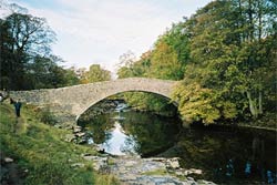
Turn right along the lane to Stackhouse where you turn right again at the finger post to the Weir and Lock. Do not cross over but turn left upriver. Again the path is very clear and follows the river, which is on your right, to the picturesque bridge at Stainforth and its waterfalls. Camera time!
Leave the river via the steps up to the lane (Grid ref. 817 672). Turn left continuing uphill passing the entrance to the caravan and camping site up to Little Stainforth. Go straight ahead over Stainforth Lane and continue up hill to a stile. You have crossed so many stiles what's one more!
Follow the path to the right, still climbing. At last you are at the top and your reward is not only superb views of the valley you have just left but Pen-y-gent (north-east) and Ingleborough (north-west). An added bonus to all this is the wide path of soft grass that very gradually descends through the pass overlooked by Smearsett and Pot Scar to terminate at Scar Close Farm in the hamlet of Feizor (Grid ref. 790 677).
On reaching Kiln Hill Lane by the farm turn left and left again. The wide path gradually climbs up to Feizor Thwaite. On reaching a finger post, turn right to Buck Haw Brow. Once again you are walking on a carpet of grass descending to Giggleswick Scar (Grid ref. 797 659).
Turn left to follow the main path that overlooks the B6480 road. The path leads to Schoolboys Tower, a low stone tower marked as a cairn on some maps. Keeping to the path bear left until you reach the quarry fence. The map is not too clear here due to extensions to the quarries since the last map survey. Take the path close to the fence descending steeply down to a field and continue descending towards the woods (Grid ref. 812 649). Then take the wide path in the woods that bears right. You will come to a low wall on your left overlooking a field. Take the very short wide path at the corner towards the cottages and onto Stackhouse Lane. Turning right along the lane brings you to the main road and turning left delivers you back to your start.
Maps 

| Ordnance Survey Explorer OL41 | Sheet Map | 1:25k | BUY |
| Anquet OS Explorer OL41 | Digital Map | 1:25k | BUY |
| Ordnance Survey Digital Map Subscription | |||
| Latest Ordnance Survey Discounts | |||
Other walks nearby
| Walk 1403 | Attermire Scar and Catrigg Force | easy/mod | 6.5 miles |
| Walk 1105 | Settle Circular | easy/mod | 6.0 miles |
| Walk 1740 | Attermire Scar & Victoria Cave | easy/mod | 5.1 miles |
| Walk 1548 | Rye Loaf Hill from Settle | moderate | 7.6 miles |
| Walk 2082 | Attermire Scar, Catrigg Force & Langcliffe | easy/mod | 7.5 miles |
| Walk 2617 | Nappa Cross & Victoria Cave from Langcliffe | moderate | 9.5 miles |
| Walk 1404 | Oxenber and Wharfe Woods from Langcliffe | moderate | 10.5 miles |
| Walk 2649 | Attermire Scar & Malham Tarn from Stainforth | mod/hard | 16.5 miles |
| Walk 1251 | The Norber Erratics & Sulber Gate | moderate | 8.0 miles |
| Walk 2620 | Sulber Gate & Crummack Dale from Austwick | moderate | 9.5 miles |
Recommended Books & eBooks
Walking in the Yorkshire Dales: South and West
 Part of a two-book set, this guidebook describes 44 walks in the southern and western Yorkshire Dales, including the famous 23 mile Three Peaks circuit over Pen-y-Ghent, Whernside and Ingleborough. The other, mostly circular routes of 3½ to 13 miles cover the scenic region between Sedbergh, Kirkby Lonsdale, Settle, Skipton and Grassington.
More information
Walking in the Yorkshire Dales: North and East
 This guidebook contains 43 circular day walks in the north and east Yorkshire Dales. It explores the dales, hills and moors between Kirkby Stephen and Pateley Bridge. Walking ranges from gentle 3 mile strolls to more strenuous day-long rambles across the Howgills, Wensleydale, Swaledale, Nidderdale, Mallerstang and Coverdale.
More information
