Oxenber and Wharfe Woods from Langcliffe
Yorkshire Dales Walk
Nat Park - Yorkshire Dales - Lower Ribblesdale
County/Area - North Yorkshire
Author - Allan Friswell
Length - 10.5 miles / 17.1 km Ascent - 1720 feet / 521 metres
Time - 7 hours 0 minutes Grade - moderate
Walk Route Description
Click image to visit gallery of 5 images.
A Yorkshire Dales walk which must be done in the second week of May to enjoy the spectacular display of wild flowers. It is a walk with quite astonishing beauty. The woods, once you arrive, are like something from Rupert or Enid Blyton - endless views under coppiced hazels and age old trees of bluebells, primroses, oxlips, cowslips, white anemone, violets and orchids. A genuinely amazing sight. There are a few heart-stirring climbs along the way but nothing that a few pauses won't cure. Ladder stiles proliferate.
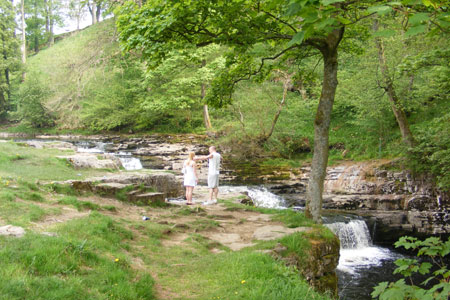
Leave the car in the car park in Langcliffe near the Institute, (grid ref. SD821650) and then make your way to the main road, where you turn right, cross the railway bridge, cross the road and then immediately follow the footpath down to the river. You will arrive at a narrow lane of cottages. Access across the river is clear - the bridge from where you get good views of the weir. At the end of the bridge, turn right and follow the river as far as Stainforth bridge, a National trust property and just above the falls where Salmon jump in October and June. On the way you will negotiate stiles, gates and that abomination, a caravan park.
Go through the stile at the end of the bridge, breathing in deeply, turn left and walk up the road. At the crossroads, turn right and this lane leads you gently uphill through open countryside on either hand. At grid ref. SD812676 take the path on the left signposted to Feizor Nick), cross the ladder stile and follow the wall, keeping on the same course as the power lines, making for the gate in the corner. When you get there you will see a sign for Feizor pointing uphill, so follow the wall and cross the ladder stile (grid ref. SD806679). Head uphill at bearing slightly left to the clearly visible ladder stile. Follow the obvious green track. At grid ref. SD801682 the path forks - take the right fork. The path eventually veers left and you cross another ladder stile (grid ref. SD794684).
Go through the next gate or use the stile, turn right, through the gate (grid ref. SD789684). After a couple of hundred yards climb the ladder stile on the left (grid ref. SD790685). Follow the path downhill to the gap in the wall in the corner. Keep ahead through another hole in the wall, heading downhill now, and over another couple of ladder stiles on the way. The geology which confronts you in the hills shows evidence of the way that successive millennia built up layers of rock, which then tilted sideways, before a final layer formed on top.
Turn left along the track parallel with the power lines. You will cross a cattle grid at grid ref. SD784689, then pass through a metal gate and follow the right hand edge of the field. Go over a ladder stile. The path is clear and, in May, there are bluebells out in the open among snippets of bracken as well as the occasional patch of ramsons (wild garlic). At grid ref. SD779687, just before you get to the gate, take the path which climbs steeply up to your left, passing the information board. The "maroon" path remains clear at all times as you enter the woods, but it divides at grid ref. SD782684, where you go left, following the "orange" path which turns sharply so that you are almost doubling back.
I have already elaborated on the beauty of these woods in May, but I cannot stress enough how impressive and glorious they are in their delicate colours and in the sheer numbers of flowers. Another stile or two. The path is obvious and leads you downhill. A final stile and then turn right along the track. Go through the gate at grid ref. SD789684, following the path downhill with masses of limestone scree on your left and open meadows and woods on your right. You are descending to the hamlet of Feizor. Once there, and once past the teashop take the step-stile on the left.
Go through the farmyard, a second gate and turn right, following the right hand wall, heading slightly uphill. Continue and go over the ladder stile, turn left and keep going uphill. The climb is steeper now, but the path remains clear at all times. Eventually it starts to descend. Go over a ladder stile. Keeping the fencing on your right, go down and then uphill after crossing the low wall. Cross the left hand ladder stile with its signpost to Feizor. Turn right and go uphill veering right following the clear green way. Yet another ladder stile, (grid ref. SD 806673), and the path then goes downhill.
Another stile by the gate, turn right, and simply follow the track. At grid ref. SD811667 the path goes off to the left, making for an obvious signpost and joining with an equally obvious green way. Another stile is next to the gate where you turn right. On reaching the corner of the left hand wall, you turn left and make for the gate about 75 yards away. Keep ahead, passing close by the pond, negotiating the gaps in two walls and following the obvious green track. Eventually you drop down to a metal gate and then follow the left hand wall steeply downhill to a gate. Follow the track to the right.
The track broadens into an unmade lane which takes you to a B road, where you cross and pass down the side of "Ribblelands" via a gate. This track brings you back to the bridge, which you cross, turn left and walk back uphill to Langcliffe.
Maps 

| Ordnance Survey Explorer OL2 | Sheet Map | 1:25k | BUY |
| Anquet OS Explorer OL2 | Digital Map | 1:25k | BUY |
| Ordnance Survey Digital Map Subscription | |||
| Latest Ordnance Survey Discounts | |||
Other walks nearby
| Walk 2603 | Feizor & Giggleswick Scar from Settle | easy/mod | 8.0 miles |
| Walk 1403 | Attermire Scar and Catrigg Force | easy/mod | 6.5 miles |
| Walk 1105 | Settle Circular | easy/mod | 6.0 miles |
| Walk 1740 | Attermire Scar & Victoria Cave | easy/mod | 5.1 miles |
| Walk 1548 | Rye Loaf Hill from Settle | moderate | 7.6 miles |
| Walk 2082 | Attermire Scar, Catrigg Force & Langcliffe | easy/mod | 7.5 miles |
| Walk 2649 | Attermire Scar & Malham Tarn from Stainforth | mod/hard | 16.5 miles |
| Walk 1251 | The Norber Erratics & Sulber Gate | moderate | 8.0 miles |
| Walk 2620 | Sulber Gate & Crummack Dale from Austwick | moderate | 9.5 miles |
| Walk 3092 | Malham Cove, Malham Tarn & Watlowes | easy | 4.4 miles |
Recommended Books & eBooks
Walking in the Yorkshire Dales: South and West
 Part of a two-book set, this guidebook describes 44 walks in the southern and western Yorkshire Dales, including the famous 23 mile Three Peaks circuit over Pen-y-Ghent, Whernside and Ingleborough. The other, mostly circular routes of 3½ to 13 miles cover the scenic region between Sedbergh, Kirkby Lonsdale, Settle, Skipton and Grassington.
More information
Walking in the Yorkshire Dales: North and East
 This guidebook contains 43 circular day walks in the north and east Yorkshire Dales. It explores the dales, hills and moors between Kirkby Stephen and Pateley Bridge. Walking ranges from gentle 3 mile strolls to more strenuous day-long rambles across the Howgills, Wensleydale, Swaledale, Nidderdale, Mallerstang and Coverdale.
More information
