Abercastle & Trefin Circular
Pembrokeshire Coast Walk
Nat Park - Pembrokeshire Coast
County/Area - Pembrokeshire
Author - Lou Johnson
Length - 7.5 miles / 12.2 km Ascent - 1000 feet / 303 metres
Time - 4 hours 50 minutes Grade - moderate
Maps 

| Ordnance Survey Explorer OL35 | Sheet Map | 1:25k | BUY |
| Anquet OS Explorer OL35 | Digital Map | 1:25k | BUY |
Walk Route Description
Click image to see photo description.
This circular walk explores the Pembrokeshire coast and countryside to the east of Trefin. The outward route uses tracks and paths to reach the coast at Pwllstrodur from the where the Pembrokeshire Coast Path is followed back to the start passing through Abercastle. This section of the coast sees fewer walkers so you can enjoy the rugged coastline in solitude.
The start is a roadside layby just under half a kilometre west of Trefin where the Pembrokeshire Coast Path joins the road (grid ref. SM834324). After parking walk uphill along the road into the centre of Trefin. Just past a stone bus shelter on the left the road splits. Take the right fork signed to Croesgoch. Follow the road downhill. Pass beneath some trees and then turn left up a narrow lane just before Prendergast Caravan Park (grid ref. SM841324). Go straight ahead at the first road junction and where the road bends sharp left, go ahead onto a signed footpath up a gravel track.
After 600 metres the track bends left. Leave the track here and follow the path with the hedge on your immediate left. After a few metres take the stile on the left and walk half right across the field to the far right-hand corner. Continue into the next field and continue straight across to a stand of trees. The path goes into the trees, heads half right and joins the access drive to Rhoslanog-fach (grid ref. SM856322). Follow this drive to reach a junction of tracks (grid ref. SM862320). Turn left and continue for about 200 metres to turn right onto a track. This track leads through buildings to reach a lane at Trefelyn (grid ref. SM867327).
Turn right along the lane. Where the lane bends right, turn left onto a grassy track with a fingerpost. The is bridleway is initially between hedges. Entering a field, follow the path with hedge left. Where the hedge ends, continue across the field to the far right-hand corner and continue with the hedge on your right to a lane Carnachen-lwyd. Turn left up the narrow lane. Take the first footpath on the right through a small metal gate and follow the hedge on the left down to the coast.
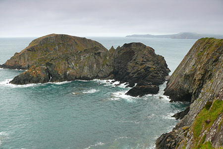
Turn left onto the Pembrokeshire Coast Path. After an initial climb, the path follows the cliff top with some fine views along the coast with many small rocky islands just off the shore. Approaching Abercastle, you pass the larger rocky island of Ynys y Castell before descending to cross the back of the beach. Turn right in front of the toilets and continue on the Pembrokeshire Coast Path.
The next section of the path is stepped in places. Do not forget to look back across to Ynys y Castell and the village of Abercastle. Regaining the clifftop path, you have more excellent views soon passing Ynys Deullyn. As with many coastal paths, there are many small ups and downs. The route then descends towards a stone bridge across a stream before joining a tarmac path back to the road and the layby.
Other walks nearby
| Walk 3477 | Porthgain, Abereiddi Bay & Blue Lagoon | easy | 3.7 miles |
| Walk 3476 | Porthgain & Blue Lagoon from Abereiddy | easy/mod | 6.5 miles |
| Walk 2056 | Pointz Castle from Solva | easy/mod | 5.5 miles |
| Walk 3479 | Strumble Head & Garn Fawr Hillfort | moderate | 6.8 miles |
| Walk 3482 | Garn Fawr & Garn Fechan Hillforts | easy | 1.5 miles |
| Walk 3480 | Strumble Head from Garn Fawr | easy/mod | 5.0 miles |
| Walk 3481 | Carregwastad Point & Strumble Head Circular | moderate | 7.7 miles |
| Walk 1997 | St. David's & Coast Path Circular | moderate | 9.7 miles |
| Walk 2057 | St. David's Head & Carn Llidi | easy/mod | 4.5 miles |
| Walk 3483 | Penberry & St Davids Head from Whitesands Bay | moderate | 9.0 miles |
Recommended Books & eBooks
The Wales Coast Path
 A single guidebook to walking the whole Wales Coast Path - 1400km (870 miles) the length of Wales from Chester to Chepstow, including Anglesey, described in 57 stages. The route passes through the Snowdonia and Pembrokeshire National Parks and many AONBs and can be linked with the Offa's Dyke Path for a complete circuit of Wales.
More information
Messaging & Social Media
Message Walking Britain and follow the latest news.

Mountain Weather
Stay safe on the mountains with detailed weather forecasts - for iOS devices or for Android devices.