Wain Stones, Bank Foot & Bloworth Crossing from Clay Bank
North York Moors Walk
Nat Park - North York Moors - North York Moors West
County/Area - North Yorkshire
Author - Andy Chaplin
Length - 14.3 miles / 23.2 km Ascent - 1800 feet / 545 metres
Time - 9 hours 0 minutes Grade - moderate
Maps 

| Ordnance Survey Explorer OL26 | Sheet Map | 1:25k | BUY |
| Anquet OS Explorer OL26 | Digital Map | 1:25k | BUY |
| Ordnance Survey Landranger 93 | Sheet Map | 1:50k | BUY |
| Anquet OS Landranger 93 | Digital Map | 1:50k | BUY |
Walk Route Description
Click image to see photo description.
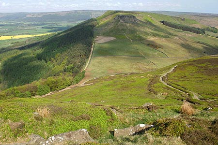
This walk continues a series of Cleveland Way circular walks designed to complete this long distance footpath in manageable sections. This route takes in the views of Farndale, Bilsdale and Ruisdale and traverses a wide range of terrain from open moorland to valley pastures. The route captures many scenic aspects of the North York Moors National Park.
From the ample car parking at grid ref NZ573036 on Clay Bank, walk south up the hill for 100 yards (where there is further on-road parking for a dozen cars) to the point where the Cleveland Way crosses the road. Take the Cleveland Way uphill on your right (west) towards the Wain Stones and at the gate bear left up the stone path towards White Hill. It is a ridge walk along to the Wain Stones with spectacular views towards Roseberry Topping on your right and Bilsdale on your left. At Wain Stones descend down initially to the right of the rocks then pick up the path again on the left as it heads down to Garfit Gap.
Continue along the Cleveland Way, passing through the way-marked gates in the valley after the Wain Stones, cross the Chop Gate to Great Broughton path and continue up and over the next hill (spot height 401 metres) from which, as you look to the south, you can see down Bilsdale to your left and Raisdale to your right. From the summit of this unnamed hill descend west on the Cleveland Way to reach a signpost that shows the path from Beak Hills. Go right on this path towards Great Broughton. Shortly afterwards, at the next sign, take the permissive bridleway towards Clay Bank. After a kilometre take the track which branches off to the left, signposted for Great Broughton (grid ref. NZ556038).
At the next junction of tracks turn right up a track marked with a footpath sign, which heads up hill. This track ends at the point where 2 gates lead off to left and right. The path continues straight ahead between two hedges and as it becomes less well defined keep over to the right with the barbed wire fence on your right. A couple of stiles amongst the undergrowth will reassure you that you are still on the path. Things open out as you come to Spring House which you pass through before reaching the road (grid ref NZ566044).
If you turn left on the road there should be a path that leads over to Water Beck Farm. I never found it and think it may now start further up the road (on the right as you come out from Spring House). Instead I turned left along the Clay Bank road, turning right onto the lane that leads to Water Beck Farm, where the path does come out-but from where? Go past Water Beck Farm, Beck House and continue on to Sycamore Farm which is at the end of the lane (grid ref. NZ581053).
Turn left into Lambs Lane, and take the first footpath on the right after Howe Hill Farm towards the house in front of you. The path goes to the right of the house, alongside the kennels, crosses the field then goes into the woods. A loop through the woods takes you down to a footbridge then up to Ingleby Manor. The path continues straight ahead past the manor and towards Bank Foot farm. Keep on the field track with the wall and hedge to your left. Come out through a gate onto the old railway incline track near Bank Foot (grid ref. NZ592060) and go left then right to make your way past the farm and up to Ingleby Bank.
Carry on uphill to rejoin the Cleveland Way (grid ref. NZ604061). Turn right (south/southwest) on the Cleveland Way and continue along the moors track to Bloworth Crossing (grid ref. NZ615015). Turn almost back on yourself, still on the Cleveland Way, and after a quarter of a mile ignore the way-marked stone path on the left which descends into a bog but carry on a little further until the old rail track meets up with the moors track. Turn left here to regain the Cleveland Way - i.e. you do not cut off a corner, but you avoid a bog.
After the Round Hill trig point the track divides (grid ref. NZ592015). Take the right hand track which then becomes a path as it continues in the general direction of White Hill. At the end of Carr Ridge there is a steep stone-stepped decent to wards the Clay Bank car park.
Other walks nearby
| Walk 1544 | Chop Gate, Round Hill & Stumps Cross | moderate | 10.1 miles |
| Walk 1469 | Carlton Bank, Scugdale, Raisdale & Kirby Bank | moderate | 10.5 miles |
| Walk 3418 | Cringle Moor & the Wain Stones | easy/mod | 6.0 miles |
| Walk 1330 | Roseberry Topping & Captain Cook's Monument | easy/mod | 6.5 miles |
| Walk 1467 | Cleveland Way - Roseberry Common to Tidy Brown Hill | moderate | 15.0 miles |
| Walk 1538 | Baysdale Circular | moderate | 9.5 miles |
| Walk 3160 | Roseberry Topping and Captain Cook's Monument | easy/mod | 6.3 miles |
| Walk 2930 | Roseberry Topping from Newton under Roseberry | easy | 3.2 miles |
| Walk 3187 | Esklets and Rosedale Head from Westerdale | moderate | 11.0 miles |
| Walk 2685 | Highcliff Nab and Guisborough Moor | moderate | 11.1 miles |
Recommended Books & eBooks
The Cleveland Way Map Booklet
 Map booklet of the Cleveland Way National Trail, a 177km (110 mile) walk around the North York Moors National Park. This booklet is included with the Cicerone guidebook to the Cleveland Way and the Yorkshire Wolds Way, and shows the full route of the Cleveland Way on Ordnance Survey 1:25,000 maps.
More information
Trail and Fell Running in the Yorkshire Dales
 Guidebook to 40 of the best trail and fell runs in the Yorkshire Dales National Park. Ranging from 5 to 24 miles, the graded runs start from bases such as Ribblehead, Dent, Sedbergh, Malham and Grassington and take in the region's diverse delights, from castles and waterfalls to iconic mountains such as Whernside, Ingleborough and Pen Y Ghent.
More information
Messaging & Social Media
Message Walking Britain and follow the latest news.

Mountain Weather
Stay safe on the mountains with detailed weather forecasts - for iOS devices or for Android devices.