Dungeness & Romney Marsh
Kent Walk
County/Area - Kent
Author - Lou Johnson
Length - 7.5 miles / 12.2 km Ascent - 50 feet / 15 metres
Time - 3 hours 50 minutes Grade - easy/mod
Walk Route Description
Click image to see photo description.
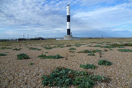
Dungeness is a unique British landscape. One of the largest expanses of shingle in the world the area has a desolate feel yet is home to interesting plant and bird life. Adding to the interest is the modern lighthouse and the one it replaced. The walk also passes the nuclear power station and offers the chance to take a steam train on the Romney, Hythe and Dymchurch Railway!
The start is the car park (grid ref. TR089169). After parking it is worthwhile acquainting yourself with the key features - including the lighthouses, railway and nuclear power station! From the car park walk west towards the boundary of the power station to turn right towards Romney Marsh. Take the marked footpath heading roughly northwest across Denge Beach. It's shingle underfoot and quite hard going but do persevere. The prominent plant here is sea kale with its large fleshy cabbage-like leaves.
The footpath leads you to Boulderwall Farm (grid ref. TR06196) where you turn left onto a grass path through the RSPB reserve heading southwest through the marshland. If you take your time you will see many birds and a pair of binoculars are useful. The path reaches a track (grid ref. TR054180). Turn left along this track towards the sea. It is worth mentioning the area now on your right is the Lydd Ranges. Do be careful if you find any munitions and report your sightings to the police.
Continue down the track, which bears right to lead down to the Boundary Tower near the beach (grid ref. TR064166). Turn left along the beach and continue past the power station as you return to Dungeness. For part of the way there is a tarmac driveway behind the beach which makes walking a lot easier. Continue as far as the new lighthouse, using the boardwalk to regain solid ground! The car park is a short distance to your left.
Maps 

| Ordnance Survey Explorer 125 | Sheet Map | 1:25k | BUY |
| Anquet OS Explorer 125 | Digital Map | 1:25k | BUY |
| Ordnance Survey Digital Map Subscription | |||
| Latest Ordnance Survey Discounts | |||
Other walks nearby
| Walk 3756 | Rye Harbour Circular | easy | 6.0 miles |
| Walk 1899 | Royal Military Canal - Cliff End to Seabrook | hard | 29.0 miles |
| Walk 3521 | Wittersham to Rye (High Weald Landscape Trail) | easy/mod | 7.5 miles |
| Walk 2923 | Folkestone to Dover along the North Downs Way | easy/mod | 8.2 miles |
| Walk 3617 | The Wye Downs and Crundale | easy/mod | 6.0 miles |
| Walk 2444 | Wye, Crundale & Wye Downs | moderate | 8.6 miles |
| Walk 2805 | Chilham circular from Wye | moderate | 17.0 miles |
| Walk 1044 | Wye and the Crundale Downs | moderate | 9.2 miles |
| Walk 1353 | Pluckley village circular | easy | 3.7 miles |
| Walk 3219 | Canterbury to Whitstable | easy/mod | 10.5 miles |
Recommended Books & eBooks
Walking in Kent
 A guidebook describing 40 walks in the county of Kent. Covering west Kent and The Weald and north and east Kent, including the Kent Downs and the Greensand Hills. Walks of 5 to 9 miles explore rivers and coastline, beautiful countryside and historic villages. With outlines of 11 longer walks ranging from 15 to 163 miles.
More information
