The Wye Downs and Crundale
Kent Walk
County/Area - Kent
Author - Lou Johnson
Length - 6.0 miles / 9.8 km Ascent - 800 feet / 242 metres
Time - 3 hours 50 minutes Grade - easy/mod
Walk Route Description
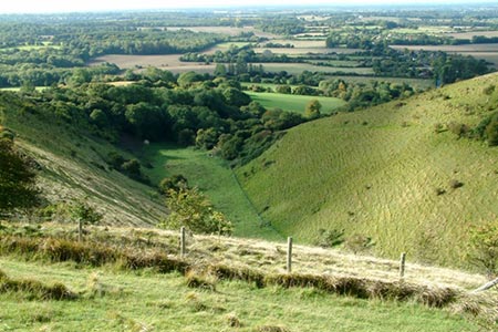
Click image to see photo description.
This Kent walk in the North Downs crosses some wonderful countryside. The start is the car park at the Devil's Kneading Trough (grid ref. TR079453) which lies on the crest of the North Downs. The route follows short sections of quiet lanes, paths and tracks which are generally signposted.
After parking, cross the road and pass through the gate opposite. Bear right onto a path that skirts the Devil's Kneading Trough (which should be on your left). Continue along the path to join the North Downs Way to a gate by the Wye National Nature Reserve car park (on your right). Continue on the path to reach a road at a gate. Cross Coldharbour Lane and continue down the lane opposite that leads to Coombe Manor.
After 600 metres turn right onto a signed bridleway. Turn left through next gate and then right onto a sunken byway. The track climbs gently and before the next gate go left over stile and then through a gate into a field. Continue across the field with woodland on your immediate left. After 600 metres or so you cross a farm track. Go straight across onto a byway. The track leads north and passes through woodland for part of the route before reaching Crundale Church, which is some way from the village (grid ref. TR085486).
Turn left along the lane and after 100 metres fork right at a signed byway to take a partly hidden path through trees. Continue through a kissing gate and follow the path across a field with woodland then a hedge to your immediate right. Reaching the next area of woodland (Viney's Wood), turn left down a steep field through a metal kissing gate to a road (grid ref. TR080492). Go straight ahead to Crundale. At the first road junction go straight ahead passing a brick-built cottage on your right. Continue up through the village passing a phone box on your left to reach a footpath sign on the left in woodland.
Turn left onto the Stour Valley Walk ignoring the right-hand arrow. Continue to a track. Turn left and then right into a field. The path runs parallel to woodland on your right. The path veers right onto a track through woodland. After 600 metres of pleasant walking through the wood, you reach a byway (grid ref. TR075478). Turn left towards Marriage Farm. Just before the farm, turn right over a stile and follow track south with the hedge on your left to reach a lane after 800 metres (grid ref. TR074468). Turn right along the lane and after 200 metres go left onto a path to Wye Crown. You are now on the North Downs Way. The path turns left after a short distance and continues across Wye Downs to a gate. Turn right, cross Coldharbour Lane and retrace your route back to the start.
Maps 

| Ordnance Survey Explorer 137 | Sheet Map | 1:25k | BUY |
| Anquet OS Explorer 137 | Digital Map | 1:25k | BUY |
| Ordnance Survey Digital Map Subscription | |||
| Latest Ordnance Survey Discounts | |||
Other walks nearby
| Walk 2444 | Wye, Crundale & Wye Downs | moderate | 8.6 miles |
| Walk 2805 | Chilham circular from Wye | moderate | 17.0 miles |
| Walk 1044 | Wye and the Crundale Downs | moderate | 9.2 miles |
| Walk 3219 | Canterbury to Whitstable | easy/mod | 10.5 miles |
| Walk 1353 | Pluckley village circular | easy | 3.7 miles |
| Walk 2923 | Folkestone to Dover along the North Downs Way | easy/mod | 8.2 miles |
| Walk 1637 | Rivers Swale & Oare | easy | 5.0 miles |
| Walk 3326 | Ringlestone & High Wood from Harrietsham | easy/mod | 8.0 miles |
| Walk 3521 | Wittersham to Rye (High Weald Landscape Trail) | easy/mod | 7.5 miles |
| Walk 2249 | Reculver & St Nicholas at Wade | easy/mod | 8.2 miles |
Recommended Books & eBooks
Walking in Kent
 A guidebook describing 40 walks in the county of Kent. Covering west Kent and The Weald and north and east Kent, including the Kent Downs and the Greensand Hills. Walks of 5 to 9 miles explore rivers and coastline, beautiful countryside and historic villages. With outlines of 11 longer walks ranging from 15 to 163 miles.
More information
