Folkestone to Dover along the North Downs Way
Kent Walk
County/Area - Kent
Author - Lou Johnson
Length - 8.2 miles / 13.3 km Ascent - 900 feet / 273 metres
Time - 5 hours 0 minutes Grade - easy/mod
Walk Route Description
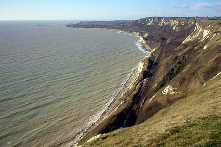
Click image to see photo description.
This walk follows the North Downs way for much of the route between Folkestone and Dover. It is a linear walk and starts from Folkestone Central station (grid ref. TR220362). To return to Folkestone use the regular train service with the railway running below the cliffs walked on the outward route.
Exit the station and turn right. At the main road, go right and cross as soon as convenient to the opposite side of the road. Go under the railway and bear left when the road forks continuing towards the sea front along Cheriton Gardens and along Cheriton Place. Cross the road and turn left (with the sea to your right and below) and continue into the Road of Remembrance to Folkestone Harbour. Bear right here taking the second road under the railway viaduct just after a zebra crossing. Almost immediately turn left into North Street and then right into the Durlocks at the next road junction. Follow this road as it bends to the left to reach a T-junction (grid ref. TR234363).
Turn right here along Wear Bay Road. You will get a view along the coast towards Dover as you proceed along this road passing a Martello Tower on your right. Continue for a further 600 metres and bear right off Wear Bay Road along a tarmac track to pass the second Martello Tower (grid ref. TR240373). Just past the Tower veer left up the ascending footpath. This leads up to the top of the cliffs and a junction with the North Dows Way National Trail. Turn right and follow this waymarked path as it follows the top of the cliffs. In the next section of the walk you have three possible refreshment stops - Battle of Britain Memorial Café, the Clifftop Café and the Lighthouse Inn.
The onward route is easy to follow with the North Downs Way well waymarked. As you get nearer to Dover the White Cliffs have rather less vegetation. Below is the Samphire Country Park constructed from spoil excavated when the Channel Tunnel was constructed. Reaching Shakespeare Cliff, you pass over the route of the Channel Tunnel and soon you are rewarded with a fine view over Dover with its castle and harbour with the White Cliffs also prominent.
After Shakespeare Cliff the North Downs Way leaves the cliffs and passes under the A20 dual carriageway. Once under the main road, bear left and then right following the waymarked North Downs Way. The OS Explorer map is useful in this area. The path continues past Western Heights, on past the Redoubt (grid ref. TR3154120) and down to the Marina. Turn left along the seafront (do not cross the road) and at the roundabout turn left along York Street. At the next roundabout turn left into Folkestone Road and the entrance to Dover Priory station is a further 300 metres on your right.
Maps 

| Ordnance Survey Explorer 138 | Sheet Map | 1:25k | BUY |
| Anquet OS Explorer 138 | Digital Map | 1:25k | BUY |
| Ordnance Survey Digital Map Subscription | |||
| Latest Ordnance Survey Discounts | |||
Other walks nearby
| Walk 3617 | The Wye Downs and Crundale | easy/mod | 6.0 miles |
| Walk 2444 | Wye, Crundale & Wye Downs | moderate | 8.6 miles |
| Walk 2381 | St Margaret's at Cliffe from Kingsdown | easy/mod | 6.3 miles |
| Walk 2805 | Chilham circular from Wye | moderate | 17.0 miles |
| Walk 1044 | Wye and the Crundale Downs | moderate | 9.2 miles |
| Walk 3219 | Canterbury to Whitstable | easy/mod | 10.5 miles |
| Walk 1531 | Dungeness & Romney Marsh | easy/mod | 7.5 miles |
| Walk 1895 | Kent Coast Path from Sandwich | easy/mod | 8.2 miles |
| Walk 1353 | Pluckley village circular | easy | 3.7 miles |
| Walk 3756 | Rye Harbour Circular | easy | 6.0 miles |
Recommended Books & eBooks
Walking in Kent
 A guidebook describing 40 walks in the county of Kent. Covering west Kent and The Weald and north and east Kent, including the Kent Downs and the Greensand Hills. Walks of 5 to 9 miles explore rivers and coastline, beautiful countryside and historic villages. With outlines of 11 longer walks ranging from 15 to 163 miles.
More information
