The Upper Mimram Valley from Ayot St Lawrence
Hertfordshire Walk
County/Area - Hertfordshire
Author - Barry Mackie
Length - 5.7 miles / 9.3 km Ascent - 450 feet / 136 metres
Time - 3 hours 20 minutes Grade - easy
Walk Route Description
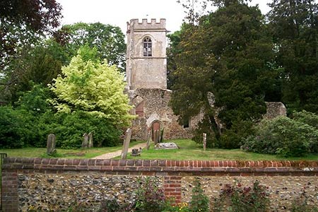
Click image to visit gallery of 12 images.
Situated on top of the southern slopes of the Mimram Valley, the village of Ayot St Lawrence is an excellent place to start and finish a very enjoyable exploration of this quiet part of the East Hertfordshire countryside. Whilst two pubs and three very diverse and interesting churches are seen during the walk, sampling some of the splendid views around the unspoilt valley might just be the highlight of the day.
Roadside parking is available adjacent to the old ruined church (grid ref TL194168) in Ayot St Lawrence. You will get a good look at the ruins from outside the boundary wall, but if the gate is unlocked it is worth going inside to get a closer look and see some of the restoration work that has been recently carried out. Also, just inside the grounds, there is an informative plaque telling of the church's extraordinary history.
Facing the church, go left (east) along the road for a short distance, passing the Brockett Arms pub to reach the right hand bend. Turn left away from the road and onto the drive (signed Manor House and Ayot House). Ten metres on from the entrance turn to the right (immediately past the cottage) and go through the gate and into the field. With the fence alongside you on the left, the faint path descends the easy slope as you head northeast to reach a wider surfaced farm track. The views of the northern slopes of the valley now start to open up as you continue on this track maintaining direction, to reach the road at the bottom of the valley.
Turn left along this road to reach the nearby T-junction; here go right along the side road (signposted to Codicote) for some 100m to cross the River Mimram at Codicote Bottom. Approximately thirty metres past the river, turn left off the road onto the waymarked bridleway, and into the woodland. The route now follows the line of the river (albeit some distance away) in a north westerly direction. Stay on this bridleway until you reach the wooden gate to your left at grid ref TL199 185, where you have a couple of choices. Either continue straight along the bridleway to reach the road, or alternatively take a short diversion through the gate and over the wooden bridge spanning the river, and then across the field to come out at Kimpton Mill (now a private residence) at the T-junction.
Whichever route you take, head north along the road, passing some commercially grown watercress beds on your left and almost at road level, some of the river on your right! As the road veers to the right (grid ref TL197 186), turn left on to the farm track signed Rye End and walk in a northerly direction, passing the cottages on your left to reach the road. Continue straight on for some twenty metres to turn left onto the gravelled drive and then almost immediately reach the impressive bridge that spans the river bed. Just past the bridge, leave the drive and cross the wooden stile on your left (grid ref TL195 193) and enter into the field. Go westerly up the slope to reach the stile under the rather unusual and nice arch formed by the branch of an oak tree.
This is also a good place to stop and enjoy the scenery all around you. On this part of the walk you can also have a look at some of the relatively unusual trees in this vicinity. Cross the stile under this "oaken" arch and follow the path alongside the edge of the next field to reach the cottages (Hoo Park Cottages) and the service road. Turn left onto this road and head down the slope in a south westerly direction to the reach the main road and the outskirts of the town of Kimpton. Turn left, do have a look at the impressive Parish Church on the upper slope to your right, and reach the T-junction. Here, this walk goes left, but if you want to stop off in Kimpton itself, go right and the first of the two local pubs is already in sight.
At the next, close by, T-junction, turn right. Follow the road up the fairly steep slope for nearly half a kilometre to then turn left away from the road at the sharp right hand bend (grid ref TL180 178). This path goes southeast alongside the edge of a field with the hedgerow initially on your right and then to your left. As the hedgerow peters out, the path veers slightly to the right and across the field to reach the edge of Prior's Wood (grid ref TL186 175). The way through the woods maintains a south east direction on a narrow, but obvious line that brings you out at the edge of a field, usually with sheep grazing in it.
Stay to the right side of the field and leave at the first gate that you come to. In front of you is a metal gate which leads into the grounds of the Greek Revivalist Church (not seen from here though). Take the path to the left of this gate through the adjacent gate, then across the field with the finish now in sight. Do look to your right as there are some remarkable views of the church frontage. The path leads to the road on the right hand side of the cottage. Turn left here and a few metres further along, you are back to the start of this walk.
Notes. Although not quite on the line of the walk, only a couple of minutes away from the start/finish point is Shaw's Corner, a National Trust property that was once the home of the playwright George Bernard Shaw. If you are interested in adding this to your day then following information may be of use. Shaw's Corner is owned and managed by the National Trust and is open to the general public. Opening days and times are - House 17th March - 28th October 1.00pm-5.00pm not Mondays or Tuesdays (except Bank Holidays) - Garden - as the house, but 12.00-5.30pm with last entry 4.30pm. A visitors' car park is close by, within the grounds
Ayot St Lawrence is a fairly isolated village and there's no easy way to get there. Whatever route you choose will include some narrow country lanes with passing places. Local road signage is good.
Maps 

| Ordnance Survey Explorer 182 | Sheet Map | 1:25k | BUY |
| Anquet OS Explorer 182 | Digital Map | 1:25k | BUY |
| Ordnance Survey Digital Map Subscription | |||
| Latest Ordnance Survey Discounts | |||
Other walks nearby
| Walk 1532 | Wheathampstead circular | easy | 4.5 miles |
| Walk 2799 | Ayot Green Circular | easy | 4.3 miles |
| Walk 2945 | Lea Valley from Batford to Mill Green | easy/mod | 8.5 miles |
| Walk 2221 | Circular from St Paul's Walden to Little Almshoe | easy/mod | 7.0 miles |
| Walk 2708 | Cuckolds Cross & Whitwell from St Paul's Walden | easy/mod | 7.0 miles |
| Walk 1139 | St Albans via Redbournbury Watermill from Harpenden | moderate | 12.0 miles |
| Walk 2457 | Stanborough Park, Welwyn Garden City | easy | 2.0 miles |
| Walk 1022 | Sandridge Circular | easy | 4.0 miles |
| Walk 1607 | Sandridge, Coleman Green & Brocket Hall Circular | easy/mod | 9.0 miles |
| Walk 2441 | Lea Valley from Mill Green to Ware | easy/mod | 9.5 miles |
