Biggin, Wolfscote & Beresford Dales from Hartington
Peak District Walk
Nat Park - Peak District - Dovedale Manifold Valley
County/Area - Derbyshire
Author - Lou Johnson
Length - 5.5 miles / 8.9 km Ascent - 400 feet / 121 metres
Time - 3 hours 10 minutes Grade - easy
Walk Route Description
Click image to visit gallery of 6 images.
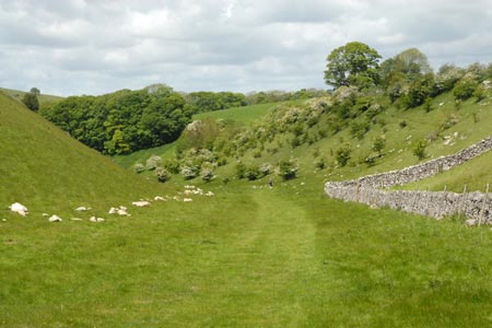
This Peak District walk explores three limestone dales to the south of the village of Hartington. The village has a range of places to eat and usually has ample parking around the duck pond. On busy days you may have to use the pay and display car park on the B5054 a short way from the centre in the direction of Hulme End. The route crosses typical Limestone country found in the 'White Peak' and also follows a section of the well-known River Dove.
To start the walk, follow the B5054 east from the village centre. Turn first right up Hall Bank. Follow the road as it climbs up to Hartington Hall (on your left). Almost opposite the Hall is walled track (grid ref. SK131603) which runs due south. Turn into this lane and follow it to its end (grid ref SK133598) continuing on a signed footpath down to Reynards Lane (grid ref SK135595) where you bear left following the lane and track down into the upper reaches of Biggin Dale.
Reaching the bottom of the Dale turn right. In a short distance you reach an open area where you bear right to start the walk down Biggin Dale with its steep valley sides. Continue down Biggin Dale until you reach Wolfscote Dale and the River Dove. The path is easy to follow although in some sections it is quite rough underfoot.
On reaching the River Dove turn right up Wolfscote Dale. This is easy walking and you will make good progress north. Continue to the footbridge at the end of Beresford Lane (grid ref SK128586) where you cross to the west bank of the River Dove and also enter Beresford Dale. The steep sided valley of Wolfscote Dale is now replaced by a shallower wooded valley. The path crosses another footbridge and after a further section through woodland emerges into open fields for the remainder of the walk back to Hartington. Reaching the main road (public toilets here!), turn right and the centre of the village is a short walk away.
Maps 

| Ordnance Survey Explorer OL24 | Sheet Map | 1:25k | BUY |
| Anquet OS Explorer OL24 | Digital Map | 1:25k | BUY |
| Ordnance Survey Digital Map Subscription | |||
| Latest Ordnance Survey Discounts | |||
Other walks nearby
| Walk 1369 | Tissington Trail - Hartington to Parsley Hey | easy | 4.0 miles |
| Walk 2455 | Lum Edge & Revidge Moor | easy/mod | 6.5 miles |
| Walk 1021 | Milldale & Hall Dale | easy/mod | 5.0 miles |
| Walk 1257 | Wolfscote Dale | easy/mod | 7.5 miles |
| Walk 1709 | Milldale and Wolfscote Dale | easy/mod | 6.5 miles |
| Walk 3597 | Manifold Valley, Thor's Cave, Ecton & Wetton Hills from Alstonefield | moderate | 10.0 miles |
| Walk 3601 | Dove & Manifold Valleys | moderate | 10.0 miles |
| Walk 3709 | Sparklow, Crowdicote & Pilsbury Circular | easy/mod | 9.0 miles |
| Walk 1181 | Wetton Hill & the Manifold Valley | easy/mod | 6.5 miles |
| Walk 1653 | The Manifold Valley from Wetton | easy/mod | 7.8 miles |
Recommended Books & eBooks
Great Mountain Days in the Pennines
 An inspirational guidebook to 50 classic walks on the rolling Pennine landscape. The graded routes, between 6 and 13 miles in length, cover classic Pennine fells and moorland such as Whernside, Ilkley Moor and Pendle Hill; exploring the North and South Pennines, Yorkshire Dales, Howgills and Dark Peak. Many routes are also suited to fell running.
More information
Dark Peak Walks
 Guidebook to 40 walks in the Dark Peak area of the Peak District National Park. 35 circular routes for most abilities, from 8km to 19km, around Edale, Marsden, Fairholmes, Baslow and Castleton, including Kinder Scout and Mam Tor, and 5 longer (25km to 45km) routes highlighting the best of the Gritstone Edges, High Moorland and Deep Valleys.
More information
