Sandridge, Coleman Green & Brocket Hall Circular
Hertfordshire Walk
County/Area - Hertfordshire
Author - Donald Morton
Length - 9.0 miles / 14.6 km Ascent - 500 feet / 152 metres
Time - 5 hours 0 minutes Grade - easy/mod
Maps 

| Ordnance Survey Explorer 182 | Sheet Map | 1:25k | BUY |
| Anquet OS Explorer 182 | Digital Map | 1:25k | BUY |
| Ordnance Survey Landranger 166 | Sheet Map | 1:50k | BUY |
| Anquet OS Landranger 166 | Digital Map | 1:50k | BUY |
Walk Route Description
Click image to visit gallery of 6 images.
Sandridge is a village a short distance from St Albans on the B651 to Weathampstead. The walk starts from the free car park next to the toilets by the side of the B651 (Grid Ref TL169104) and for the first couple of miles or so uses the route of the Hertfordshire Way.
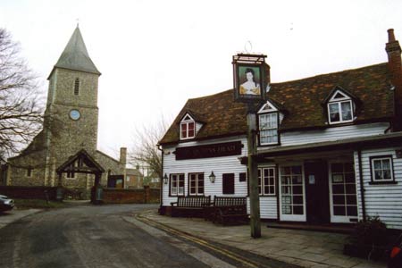
On leaving the car park take the zebra crossing over the B651 and turn left along the road. Turn right up Church End going past The Queen's Head to arrive at the church, founded by the Abbey of St Albans as a chapel in the 12th Century. Enter the churchyard and pass to the left of the church to exit the churchyard into a lane. Cross the lane and go through the barrier to turn right on a track initially parallel to the lane. Cross over an estate road and straight on along a footpath signed to Hammonds Lane. This uses a broad field break, continuing along a field edge, hedge right. On reaching a wood fork right and continue parallel to the wood edge.
On emerging continue straight on along the field edge, hedge left. You come out to a lane - Hammonds Lane. Turn right and walk along this quiet lane, passing Tower Hill Lane on the left. Soon after, just before a large house, go over a stile on the left and along the field edge, with the large house on the right. After a stile continue along an enclosed path and the edge of woods. After another stile still continue straight on along a field edge - woods right, until reaching a waymark post with multiple direction signs. Here turn left across the arable field. After meeting a hedge on the left, at the field corner turn left through what used to be a stile and along the field edge, hedge left. This ends past a metal barrier/gate at the road in the hamlet of Coleman Green. Turn right and leaving the Hertfordshire Way pass the John Bunyan PH to reach on the right a solitary chimney, all that remains of a pair of cottages, and known as "John Bunyan's chimney" since there is a tradition that the preacher stayed here when he was making his preaching tours.
A public byway signed to Marford Road turns right off the road in front of the chimney. Follow this sunken lane downhill all the way to the B653 (Grid Ref TL204132). As you walk imagine the heavy carts going up and down a couple of centuries and more ago; there appear to be few passing places so imagine also the altercations between opposing carters, perhaps fisticuffs if one side was well lubricated at the tavern in Coleman Green - carters had a bit of a reputation both for lubrication and roughness. At the B653 a path to the left brings you up to the road. Cross over and turn right to a large lay-by. The OS map and the finger post indicate that the required footpath start from the far end of the lay-by. This protects the right of way if the layby should close but for practical purposes the path starts at the fence gap at the midway point of the layby.
Having noted the welcoming sign from the Brocket Estate follow the footpath from here down by the barbed wire fence through the woods down to the River Lea. Cross over the bridge and continue up to a cross path. Here turn right and, joining the Lea Valley Walk - a 50 mile trail from Leagrave to the Thames - for a short distance, ascend a sharp rise through woods. At the top emerge onto a golf course and follow the line of waymark posts to reach the corner of the club house car park. From this point the path follows a wooden fence with the golf course to the left and, to the right, views of Melbourne House, the Lea which has been dammed to form a lake as a feature of the parkland, and eventually glimpses of Brocket Hall built in 1790 now an event venue but one time home of Lord Melbourne, the Victorian Prime Minister, and more recently of the eponymous (and criminal - insurance fraud) Lord Brocket. The path cuts across a drive and continues now along an old iron fence until a drive cuts across again.
This time, leaving the Lea Valley Walk, turn right on the drive and follow it down to the Palladian Bridge from which there are much better views of the house across the lake. Once over the bridge, leave the drive to continue straight on up a grassy slope following waymark posts and then the edge of woods to the B653 (Grid Ref TL209124). Cross over and continue down Cromer Hyde Lane. At the end of the houses, look for a footpath to the left. Follow this wide farm track across open fields with wide views until it swings left and at this point go straight on, following waymark posts. The new track swings right across the open upland. After going through a hedge gap it follows the field edge, hedge right. After another open section it again becomes a field edge path, woods and hedge now left, terminating in an enclosed cinder track passing to the left of Symonshyde Farm house. After going through the farm with a schooling ring on the left and past wooden gates a drive comes out to a lane (Grid Ref TL198112).
Turn right and after about 60 yards turn left onto a bridle path going through Symonshyde Great Wood. Here the going is firm even after wet weather. At a T-junction turn left to follow a ditch on the left. At a waymark post turn right and then curve left along the edge of the woods, eventually emerging to continue forward along a field edge by the side of the woods (maybe muddy ). Eventually this turns into an enclosed path which leads down to a lane. Turn right and follow this quiet lane past a high security government installation labelled "Home Office Scientific Development Branch" (reading these words together may remind you of "1984" and a visit to the HO website is not totally reassuring) until you come to a T-junction. Turn right along the pavement to arrive back in Sandridge opposite The Green Man and hard by The Rose and Crown. Turn left along the B651 to the car park.
Other walks nearby
| Walk 1122 | St Albans & Childwick Green | easy | 4.0 miles |
| Walk 1532 | Wheathampstead circular | easy | 4.5 miles |
| Walk 1343 | St Albans & Gorhambury circular | moderate | 9.5 miles |
| Walk 1139 | St Albans via Redbournbury Watermill from Harpenden | moderate | 12.0 miles |
| Walk 2945 | Lea Valley from Batford to Mill Green | easy/mod | 8.5 miles |
| Walk 2457 | Stanborough Park, Welwyn Garden City | easy | 2.0 miles |
| Walk 2799 | Ayot Green Circular | easy | 4.3 miles |
| Walk 1372 | Ayot St Lawrence Circular | easy | 6.0 miles |
| Walk 2338 | The Upper Mimram Valley | easy | 5.7 miles |
| Walk 2944 | Ayot St Lawrence to Ayot St Peter Circular | easy | 4.6 miles |
Recommended Books & eBooks
No suggestions for this area.Messaging & Social Media
Message Walking Britain and follow the latest news.

Mountain Weather
Stay safe on the mountains with detailed weather forecasts - for iOS devices or for Android devices.