Rivers Swale & Oare from Faversham
Kent Walk
County/Area - Kent
Author - Lou Johnson
Length - 5.0 miles / 8.1 km Ascent - 50 feet / 15 metres
Time - 2 hours 30 minutes Grade - easy
Walk Route Description
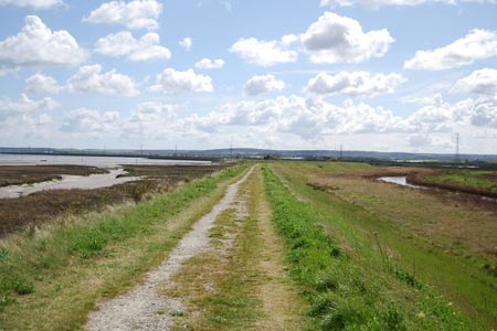
Click image to see photo description.
This walk explores the marshes, creeks and tideways on the south side of The Swale. On the far side of the water is the Isle of Sheppey and in season the area is an excellent place for watching birdlife. The start is the car park at grid ref. TR012647 which can easily be reached from Oare village and the centre of Faversham.
After parking follow the Saxon Shore Way west (with the Swale on your right). Reaching a disused jetty (grid ref. TR005652), turn left onto a signed bridleway. This leads through Uplees to reach a tarmac road (grid ref. TQ999643). Cross the road and follow the footpath towards Poplar Hall. You cross the access road for Howletts to join a track that leads past Poplar Hall. At grid ref. TQ994636 leave the track and take the footpath Luddenham Court with its fine church.
Just past the church take the footpath on your left. This leads east, crossing a minor road where it becomes a track to reach a junction of tracks/paths at grid ref. TQ998631. Bear right here to leave the track taking the footpath to Uplees Road on the outskirts of Oare village (grid ref. TR004630). Turn right down this road into the centre of the village.
Continue straight through the village to reach Oare Creek on your left (grid ref. TR007627). Turn left here onto Saxon Shore Way and with the water to your right walk north following the clear path alongside the creek and back to the start.
Maps 

| Ordnance Survey Explorer 149 | Sheet Map | 1:25k | BUY |
| Anquet OS Explorer 149 | Digital Map | 1:25k | BUY |
| Ordnance Survey Digital Map Subscription | |||
| Latest Ordnance Survey Discounts | |||
Other walks nearby
| Walk 3219 | Canterbury to Whitstable | easy/mod | 10.5 miles |
| Walk 2805 | Chilham circular from Wye | moderate | 17.0 miles |
| Walk 1044 | Wye and the Crundale Downs | moderate | 9.2 miles |
| Walk 2444 | Wye, Crundale & Wye Downs | moderate | 8.6 miles |
| Walk 3326 | Ringlestone & High Wood from Harrietsham | easy/mod | 8.0 miles |
| Walk 3617 | The Wye Downs and Crundale | easy/mod | 6.0 miles |
| Walk 2249 | Reculver & St Nicholas at Wade | easy/mod | 8.2 miles |
| Walk 1353 | Pluckley village circular | easy | 3.7 miles |
| Walk 2920 | Egypt Bay & St Mary's Bay from High Halstow | easy | 7.5 miles |
| Walk 2104 | Blue Bell Hill to Kit's Coty House | easy/mod | 8.8 miles |
Recommended Books & eBooks
Walking in Kent
 A guidebook describing 40 walks in the county of Kent. Covering west Kent and The Weald and north and east Kent, including the Kent Downs and the Greensand Hills. Walks of 5 to 9 miles explore rivers and coastline, beautiful countryside and historic villages. With outlines of 11 longer walks ranging from 15 to 163 miles.
More information
