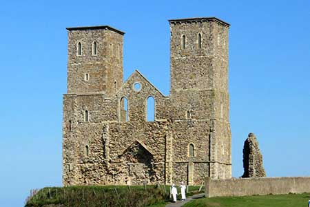
Reculver & St Nicholas at Wade
Kent Walk
County/Area - Kent
Author - Lou Johnson
Length - 8.2 miles / 13.3 km Ascent - 100 feet / 30 metres
Time - 4 hours 10 minutes Grade - easy/mod
Walk Route Description
Click image to see photo description.
Starting from Reculver this walk explores a section of the Kent coast. The route follows a path across low-lying land to the village of St Nicholas at Wade. The walk then turns towards the coast to join the Thanet Coastal Walk back to the start. The imposing twin towers of the medieval church at Reculver dominate the skyline of Herne Bay and are passed early in the walk and again at the end.
The walk starts from Reculver Public car park (pay and display) on the sea front (grid ref. TR226693). After parking walk towards the twin towers, keeping them on your left. Continue to the sea and at the first stone groyne jutting out to sea, turn right to walk beside a small lagoon on your left. At the end of the lagoon, bear left to join a path along the Rushbourne Sea Wall. After a kilometre the path turns right and continues to the railway (grid ref. TR242685). Do not cross the railway and turn left along a path running beside the railway for 600 metres. Cross the railway with care and continue across the River Wantsum to a junction of paths (grid ref. TR250683).
Turn right and follow the clear track to reach a lane and farm at Chambers Wall. Bear left along the lane and then first right (signed to St Nicholas at Wade). Cross the A299 and continue along Court Road into the centre of the village. Reaching a junction with the parish church ahead, bear left and then take the first lane on the left (Shuart Lane) beside the church. Cross the footbridge over the A299 and continue along the lane on the other side. At the two-way fingerpost, turn left and follow the track towards the sea. Re-cross the railway (again with care) and continue towards sea.
Turn left along the Thanet Coastal Wall which follows the substantial protection offered by the Northern Sea wall to the low-lying fields inland. An easy walk of just over four kilometres leads you back to the twin towers and the start of the walk in Reculver.
Maps 

| Ordnance Survey Explorer 150 | Sheet Map | 1:25k | BUY |
| Anquet OS Explorer 150 | Digital Map | 1:25k | BUY |
| Ordnance Survey Digital Map Subscription | |||
| Latest Ordnance Survey Discounts | |||
Other walks nearby
| Walk 3219 | Canterbury to Whitstable | easy/mod | 10.5 miles |
| Walk 1895 | Kent Coast Path from Sandwich | easy/mod | 8.2 miles |
| Walk 1561 | Ramsgate to Margate, Isle of Thanet | easy/mod | 7.8 miles |
| Walk 1637 | Rivers Swale & Oare | easy | 5.0 miles |
| Walk 2381 | St Margaret's at Cliffe from Kingsdown | easy/mod | 6.3 miles |
| Walk 3617 | The Wye Downs and Crundale | easy/mod | 6.0 miles |
| Walk 2444 | Wye, Crundale & Wye Downs | moderate | 8.6 miles |
| Walk 2805 | Chilham circular from Wye | moderate | 17.0 miles |
| Walk 1044 | Wye and the Crundale Downs | moderate | 9.2 miles |
| Walk 2923 | Folkestone to Dover along the North Downs Way | easy/mod | 8.2 miles |
Recommended Books & eBooks
Walking in Kent
 A guidebook describing 40 walks in the county of Kent. Covering west Kent and The Weald and north and east Kent, including the Kent Downs and the Greensand Hills. Walks of 5 to 9 miles explore rivers and coastline, beautiful countryside and historic villages. With outlines of 11 longer walks ranging from 15 to 163 miles.
More information
