Race Head & Sedling Rake from Wearhead
North Pennines Walk
Region - North Pennines
County/Area - Durham
Author - Lou Johnson
Length - 6.0 miles / 9.8 km Ascent - 1200 feet / 364 metres
Time - 4 hours 10 minutes Grade - easy/mod
Walk Route Description
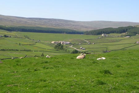
Click image to see photo description.
This walk explores the high ground and open country to the north of Weardale. The start is the village of Wearhead on the A689 between Stanhope and Alston. Limited on street parking is available in the village although please be considerate to local residents. It is suggested you take a 1:25000 OS map to help with navigation as the area is criss-crossed by many rights of way.
From the bridge over the River Wear (grid ref. NY858395) walk north along the main road. Ignore the first turn on the right (an access to house frontages) and take the second street which bends to the left. Almost immediately bear right to locate the footpath/green track leading uphill with a wall to your left. Continue climbing to reach a lane (grid ref. NY862397). Turn right along the lane Almost immediately turn left up a track that leads past Halliwell House and into open country keeping the wall to your right.
Passing through a gate the wall switches to the other side and you soon reach a bridleway crossing from right to left (grid ref. NY468407). Turn right along this bridleway along Sedling Rake continuing for just under a mile passing Race Head en-route. There is a small area of woodland on your right before you meet a tarmac lane (grid ref. NY884404). Turn right down this lane to reach a walled lane on your left (grid ref, NY882401). The way ahead enters a field. With a wall on your left continue on this bridleway for approximately half a mile from the tarmac lane. Reaching the next cross wall turn right onto a feint path that follows the wall south west (wall on your left) at grid ref. NY886394).
The path continues down to a road junction (grid ref. NY883386) below Carr Brow Pastures. Turn right along the lane through a sharp bend to pass Level Gate on your left. Almost immediately take the rough track on your right to cross a road (grid ref. NY877392). Continue ahead a much better track that leads you to Allercleugh. Here, continue straight ahead, now on a footpath, to High Whitestones. The path goes to the left of the house and follows the access road down to Whitestones Farm where the path leaves the track to drop down to a lane (grid ref. NY868392).
The onward path goes between the buildings opposite, goes right towards a gate. The path then drops down to a road. Turn right and cross the River Wear almost immediately turning right onto an access track Waterside Farm. You are now on the Weardale Way. The route continues across a number of fields to reach the A689 near the bridge over the Wear in Wearhead.
Maps 

| Ordnance Survey Explorer OL31 | Sheet Map | 1:25k | BUY |
| Anquet OS Explorer OL31 | Digital Map | 1:25k | BUY |
| Ordnance Survey Digital Map Subscription | |||
| Latest Ordnance Survey Discounts | |||
Other walks nearby
| Walk 2393 | Weardale Circular from Westgate | easy/mod | 6.4 miles |
| Walk 3424 | Cronkley Fell | easy/mod | 7.0 miles |
| Walk 3526 | Hanging Shaw, Cronkley Scar, Low Force & High Force | moderate | 12.7 miles |
| Walk 3274 | Cronkley Scar & Cauldron Snout | moderate | 8.0 miles |
| Walk 1683 | High Cup Nick & Cow Green Reservoir | moderate | 12.8 miles |
| Walk 3336 | Cauldron Snout | easy | 3.6 miles |
| Walk 3593 | Meldon Hill from Cow Green Reservoir | moderate | 9.2 miles |
| Walk 3758 | Tynehead and Ashgill Force from near Garrigill | easy/mod | 8.2 miles |
| Walk 1084 | Garrigill, Alston & Nenthead | moderate | 13.1 miles |
| Walk 3099 | High Force, Low Force and the River Tees | easy/mod | 7.5 miles |
Recommended Books & eBooks
Great Mountain Days in the Pennines
 An inspirational guidebook to 50 classic walks on the rolling Pennine landscape. The graded routes, between 6 and 13 miles in length, cover classic Pennine fells and moorland such as Whernside, Ilkley Moor and Pendle Hill; exploring the North and South Pennines, Yorkshire Dales, Howgills and Dark Peak. Many routes are also suited to fell running.
More information
Walking in the North Pennines
 This guidebook describes 50 day walks across the North Pennines, England's remotest Area of Outstanding Natural Beauty taking in parts of Cumbria, County Durham and Northumberland. Most of the routes are circular and they range from 5 to 14 miles, with something to suit all abilities. Route descriptions are accompanied by 1:50K OS mapping.
More information
