High Force, Low Force and the River Tees from Bowlees
North Pennines Walk
Region - North Pennines
County/Area - Durham
Author - Lou Johnson
Length - 7.5 miles / 12.2 km Ascent - 850 feet / 258 metres
Time - 4 hours 40 minutes Grade - easy/mod
Walk Route Description
Click image to visit gallery of 9 images.
The River Tees is a river of contrasts beginning its life on the isolated flanks of Cross Fell and entering the North Sea surrounded by industry. The section of the river contained in this route provides a perfect basis for a walk with the inclusion of two fine waterfalls, pleasant rural surroundings, two fine examples of public art and a return across open country to the small village of Holwick.
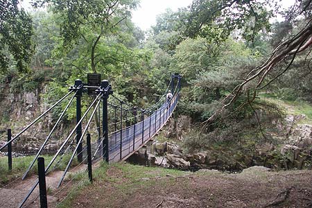
The start is the car park (Grid ref. NY907282) adjacent to the Bowlees Visitor Centre about 3 miles northwest along the B6277 from Middleton-in-Teesdale. After parking exit the car park using the footbridge. Continue past the visitor centre (well worth a visit if open) and continue down the lane to main road. Go straight across and follow the signed footpath to Wynch Bridge. Entering woodland on the banks of the Tees, it is worthwhile making a short diversion to the riverbank to the right of Wynch Bridge to get your first look at Low Force. After rain the falls, although lacking height, can be very dramatic as the Tees flows south. Return to the bridge and, taking note of the sign above your head, cross this historic structure. Information boards provide a detailed and very interesting history and some anecdotes about its past. Reaching the far bank of the river, turn right to join the Pennine Way National Trail on its way north to the Scottish border at Kirk Yetholm. Almost immediately you pass Low Force on your right.
Staying on the riverside path continue upstream. The first piece of public art is soon reached as you cross a beautiful stile with two sheep carved from limestone. Continuing alongside the river, the walking is pleasant and quite soon you are able to hear High Force waterfall. Before reaching the falls the path climbs a little with the river confined to a rocky gorge. Look out for a vantage point on your right from where you get an almost perfect view of High Force. This is the largest waterfall in England which you are able to enjoy free of charge. As an alternative you can park at the High Force Hotel and pay a toll to use the path on the opposite bank.
After enjoying the spectacle continue upstream following the Pennine Way. You pass a large working quarry on the far bank after which the path crosses two footbridges close together (Grid ref. NY867280) and begins to climb a small grassy hill. At the time of writing (2006), there was a small barn for sheep to shelter in on the top of this hill. Shortly after this, turn left off the Pennine Way and go through a gate in the wall. Continue on this path a short way to reach a green way (Grid ref. NY860280). Turn left and follow this broad track across open country with a wall to your left. Crossing a stream, the track climbs gently with the wall to your left but after a short way the track continues ahead with the wall veering left. Reaching the brow of the hill the way ahead is clear with good views to your left across the River Tees and the ground you have just walked.
Joining a track (Grid ref. NY880275) continue ahead towards Holwick Scar. Stay on the track as descends past the first crags and cross the superb stile with its two sheep carvings on the right of track. Commissioned by the local landowner, the sheep and grouse are intended to show the delicate balance of fauna on the moorland. Once over the stile continue along the track towards Holwick village. Go through the gate by the first cottage and walk ahead on the tarmac lane. At the junction turn left down the lane and follow this until it bears left towards Holwick Lodge. At the bend in the road (Grid ref. NY903274) take the signed footpath across fields to Wynch Bridge. Cross the bridge, perhaps reacquaint yourself with Low Force, and follow the outward route back to the car park. In season there are refreshments available at the visitor centre.
Maps 

| Ordnance Survey Explorer OL31 | Sheet Map | 1:25k | BUY |
| Anquet OS Explorer OL31 | Digital Map | 1:25k | BUY |
| Ordnance Survey Explorer OL19 | Sheet Map | 1:25k | BUY |
| Anquet OS Explorer OL19 | Digital Map | 1:25k | BUY |
| Ordnance Survey Digital Map Subscription | |||
| Latest Ordnance Survey Discounts | |||
Other walks nearby
| Walk 3424 | Cronkley Fell | easy/mod | 7.0 miles |
| Walk 3526 | Hanging Shaw, Cronkley Scar, Low Force & High Force | moderate | 12.7 miles |
| Walk 1005 | Harter Fell & Grassholme | moderate | 8.0 miles |
| Walk 1482 | Crossthwaite Common from Middleton-in-Teesdale | moderate | 9.8 miles |
| Walk 1483 | Eggleston & Romaldkirk from Middleton-in-Teesdale | easy/mod | 9.8 miles |
| Walk 1484 | Kirkcarrion from Middleton-in-Teesdale | easy | 3.5 miles |
| Walk 1485 | Hamsterley & Middleton-in-Teesdale | mod/hard | 16.5 miles |
| Walk 1488 | Middleton-in-Teesdale Railway Walk | easy | 2.5 miles |
| Walk 2258 | Grassholme Reservoir from Middleton-in-Teesdale | moderate | 8.2 miles |
| Walk 2228 | Romaldkirk Moor | easy/mod | 7.6 miles |
Recommended Books & eBooks
Great Mountain Days in the Pennines
 An inspirational guidebook to 50 classic walks on the rolling Pennine landscape. The graded routes, between 6 and 13 miles in length, cover classic Pennine fells and moorland such as Whernside, Ilkley Moor and Pendle Hill; exploring the North and South Pennines, Yorkshire Dales, Howgills and Dark Peak. Many routes are also suited to fell running.
More information
Walking in the North Pennines
 This guidebook describes 50 day walks across the North Pennines, England's remotest Area of Outstanding Natural Beauty taking in parts of Cumbria, County Durham and Northumberland. Most of the routes are circular and they range from 5 to 14 miles, with something to suit all abilities. Route descriptions are accompanied by 1:50K OS mapping.
More information
