Tynehead and Ashgill Force from near Garrigill
North Pennines Walk
Region - North Pennines
County/Area - Cumbria - North Cumbria
Author - Lou Johnson
Length - 8.2 miles / 13.3 km Ascent - 900 feet / 273 metres
Time - 5 hours 0 minutes Grade - easy/mod
Walk Route Description
Click image to see photo description.
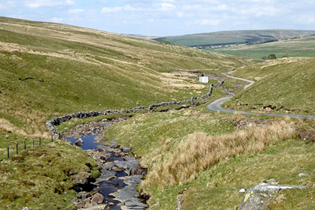
This walk from near Garrigill in Cumbria explores Ashgill Force and the upper reaches of the River South Tyne to its accepted source. The route provides the walker with a detailed visit to Ashgill Force before heading up the valley to pass several more waterfalls as you gradually gain height to reach the watershed with upper Teesdale.
To reach the start drive south through Garrigill and reaching the end of the village bear left onto a no-though road and continue south into the valley. Continue to cross Crossgill Bridge and 200 metres beyond the bridge there is a parking space suitable for a car (grid ref. NY748407). After parking walk back towards Garrigill, cross the bridge, and take the first footpath on the right through a wooden gate (grid ref. NY748408). Follow the walled track, cross Windshaw Bridge over the River South Tyne and turn right onto the South Tyne Trail.
The path follows the river upstream through a gorge. The path then turns left up Ashgill. Reaching a four-way finger post, continue ahead, cross a bridge, and continue up to Ashgill Force, which after heavy rain is an impressive sight. To continue, return to the four-way fingerpost and turn left over the footbridge and continue along the South Tyne Trail. Approaching Hole House Farm the path fades. The onward path crosses an awkward stone stile on your left above the stream.
Pass to the left of Hole House Farm and continue upstream. Continue across a track leading left to Tynehead Farm (grid ref. NY762380). Cross a footbridge, go through gate on the left and continue upstream. Pass ruined buildings and waterfalls to reach a private road which leads to Moor House in Teesdale. Follow this road to reach the source of the Tyne which is marked by a stone sculpture (grid ref. NY753350) and the watershed at 557 metres above sea level.
The return to the start is a relaxing downhill walk initially following the private road to reach a cattle grid and the public road (grid ref. NY757384). Continue down the quiet road for 2.5 kilometres back to the start.
Maps 

| Ordnance Survey Explorer OL31 | Sheet Map | 1:25k | BUY |
| Anquet OS Explorer OL31 | Digital Map | 1:25k | BUY |
| Ordnance Survey Digital Map Subscription | |||
| Latest Ordnance Survey Discounts | |||
Other walks nearby
| Walk 1084 | Garrigill, Alston & Nenthead | moderate | 13.1 miles |
| Walk 2195 | Alston & Garrigill | easy/mod | 8.7 miles |
| Walk 1659 | Race Head & Sedling Rake from Wearhead | easy/mod | 6.0 miles |
| Walk 3274 | Cronkley Scar & Cauldron Snout | moderate | 8.0 miles |
| Walk 1683 | High Cup Nick & Cow Green Reservoir | moderate | 12.8 miles |
| Walk 3336 | Cauldron Snout | easy | 3.6 miles |
| Walk 3593 | Meldon Hill from Cow Green Reservoir | moderate | 9.2 miles |
| Walk 3071 | Cross Fell & Great Dun Fell from Kirkland | mod/hard | 12.0 miles |
| Walk 1715 | Dufton Pike & Dufton | easy | 5.0 miles |
| Walk 3424 | Cronkley Fell | easy/mod | 7.0 miles |
Recommended Books & eBooks
Outdoor Adventures with Children - Lake District
 Guidebook to 40 outdoor adventures in the Lake District with children under 12, including walking, cycling, orienteering, paddling, boating, hostelling and more. Graded activities for varying age ranges or for families with children of different ages.
More information
Hadrian's Wall Path
 Hadrians Wall Path guidebook to walk the 84 mile National Trail. Described in both directions, the main description is west to east between Bowness-on-Solway and Wallsend, Newcastle, with extensions to Maryport and South Shields. With extensive historical information related to this World Heritage site and separate 1:25,000 OS map booklet included.
More information
