Win Hill from Hope
Peak District Walk
Nat Park - Peak District - Great Ridge Castleton
County/Area - Derbyshire
Author - Lou Johnson
Length - 6.5 miles / 10.6 km Ascent - 1100 feet / 333 metres
Time - 4 hours 20 minutes Grade - easy/mod
Maps 

| Ordnance Survey Explorer OL1 | Sheet Map | 1:25k | BUY |
| Anquet OS Explorer OL1 | Digital Map | 1:25k | BUY |
| Ordnance Survey Landranger 110 | Sheet Map | 1:50k | BUY |
| Anquet OS Landranger 110 | Digital Map | 1:50k | BUY |
Walk Route Description
Click image to visit gallery of 12 images.
Win Hill occupies a wonderful position near the village of Hope. The views from the summit are superb with Lose Hill and the Castleton Ridge, Edale, the moors of Kinder Scout, Ladybower Reservoir and the wild moors and edges of the eastern Peak District all included in a glorious panorama. The walk includes a variety of landscapes and does include one section of fairly steep uphill walking. However there are plenty of excuses to stop and enjoy the view during the climb.
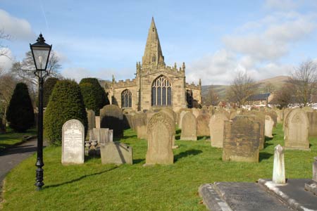
The start of this Peak District walk is the village of Hope, which lies on the A6187 between Hathersage and Castleton in the Peak District National Park. Parking is available on the south side of the A6187 (Grid ref. SK171834) and in other parts of the village. However do remember to park considerately. The village has a number of cafes, pubs and shops.
After parking take the Edale Road (opposite the church), pass the primary school on your left then turn right down a lane marked "no through road" - Bowden Lane. Cross a stone bridge carry straight on and go under a railway arch. Turn right immediately after the arch along a track signposted Twitchill Farm Cottages (grid ref. SK172842). Follow the track uphill to Twitchill Farm where you continue through the yard and following the clearly marked right of way climb steeply up through a field.
The path crosses a stile and enters rougher ground. Continue the climb with constantly improving views making the ascent more enjoyable. The path ahead is clear and quite soon you will be able to see the rocky outcrops that mark the summit of Win Hill. Crossing a fence you reach the main ridge path (grid ref. SK183850) that links the summit of Win Hill with Hope Cross. Turn right on this and continue to the summit. To gain the trig column you can either take the path or for the more adventurous a mild scramble over the rocks will give you more direct access.
Having enjoyed the view retrace your steps and follow the main ridge path towards Hope Cross. The broad path heads west at first but soon swings north-westerly with superb views into Edale and across to Kinder on your left. The path undulates across rough pasture and eventually runs along side a forestry plantation on your right. Stay on the path until you reach a broken wall at grid ref. SK165868 (approx.). Turn left downhill alongside the walk to meet a broad track descending south-west into the valley. Turn left on this and descend towards Hope.
The track joins a tarmac lane (grid ref. SK170853) which you follow until the lane bends sharp right near Fullwood Farm (grid ref. SK170848). Here you leave the lane and take the signed footpath on your left. This leads across fields to reach another lane. Continue down the lane bearing right under the railway bridge, which you used near the beginning of the walk. Follow the lane up to the Edale Road and turn left to reach the centre of Hope village.
Other walks nearby
| Walk 1087 | Mam Tor & Cave Dale | moderate | 6.5 miles |
| Walk 1519 | Catleton & Speedwell Cavern Circular | easy | 4.3 miles |
| Walk 1521 | Cave Dale and Winnats Pass | easy | 4.5 miles |
| Walk 1665 | Hollins Cross & Lose Hill | easy/mod | 6.0 miles |
| Walk 3426 | Lose Hill & Hollins Cross | easy/mod | 5.0 miles |
| Walk 1080 | Shatton Moor and Offerton | easy/mod | 7.5 miles |
| Walk 2588 | Win Hill & Hope Cross | moderate | 7.5 miles |
| Walk 1688 | Old Dam & Sparrowpit from Mam Nick | moderate | 9.0 miles |
| Walk 3620 | Bretton Clough & Abney Moor | easy/mod | 6.0 miles |
| Walk 1270 | Abney Circular | easy/mod | 7.2 miles |
Recommended Books & eBooks
Dark Peak Walks
 Guidebook to 40 walks in the Dark Peak area of the Peak District National Park. 35 circular routes for most abilities, from 8km to 19km, around Edale, Marsden, Fairholmes, Baslow and Castleton, including Kinder Scout and Mam Tor, and 5 longer (25km to 45km) routes highlighting the best of the Gritstone Edges, High Moorland and Deep Valleys.
More information
Walking in Derbyshire
 Walking guidebook to 60 circular day walks in Derbyshire and the Peak District. Includes the Derwent, Wye and Trent river valleys, near Derby, Matlock, Glossop, Bakewell and Ripley. Routes range from easy to moderate and are between 4 and 14km (2 to 10 miles). Walks focus on places of interest, from Stone Age forts to castles to grand estates.
More information
Messaging & Social Media
Message Walking Britain and follow the latest news.

Mountain Weather
Stay safe on the mountains with detailed weather forecasts - for iOS devices or for Android devices.