Virginia Water & the Wentworth Estate
Surrey Walk
County/Area - Surrey
Author - Peter Smyly
Length - 9.0 miles / 14.6 km Ascent - 100 feet / 30 metres
Time - 4 hours 40 minutes Grade - easy/mod
Maps 

| Ordnance Survey Explorer 160 | Sheet Map | 1:25k | BUY |
| Anquet OS Explorer 160 | Digital Map | 1:25k | BUY |
| Ordnance Survey Landranger 175 | Sheet Map | 1:50k | BUY |
| Anquet OS Landranger 175 | Digital Map | 1:50k | BUY |
Walk Route Description
Click image to visit gallery of 8 images.
This walk involves an anti-clockwise circuit of the lake at Virginia Water in Surrey and additionally includes a "there and back" detour to Savill Gardens and Obelisk Pond. The route is mostly on the level on clear paths with a few gentle slopes up and down and, as long as the ground is dry, a pair of trainers should suffice rather than walking boots. One of the easiest ways to do the walk is to start from the car park to the east of the lake (see walk 1821). However, this walk route involves taking a train to the station with the same name as the lake, Virginia Water. This entails walking a mile next to a main road on the approach to the lake, but there is a quieter and greener alternative return route by way of some of the back roads of the Wentworth Estate, passing Wentworth Golf Course. Or, of course, you could use the quieter back roads in both directions.
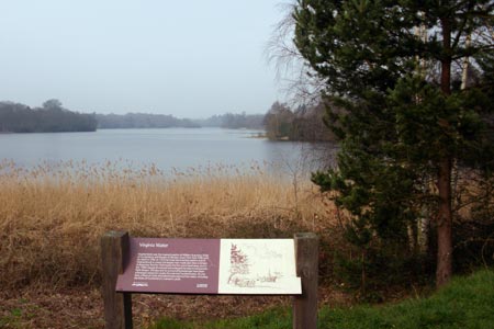
From the rail station (grid ref. TQ001678), pass the row of shops to the left and follow Christchurch Road to the west. After a mile, you reach a T junction where you need to cross London Road, by which point the lake can now be seen beyond the car park. Beyond the car park, a sign by the lake shore indicates the way to particular landmarks and indicates that a circuit of the lake is four and a half miles long. Turn right and follow the path by the lake until you reach Wick Pond with the giant Totem Pole beyond it.
Taking the path to the right of Wick Pond and passing the Totem Pole leads to Obelisk Pond, the reason for the name being obvious due to the tall obelisk on the hill overlooking the pond. Follow the path along the dam then the path turns left to a grassy area on a slight hill with tall trees and picnic tables. Savill Gardens is nearby where there is a shop, a café and public conveniences.
Returning to the Totem Pole, the circuit of the lake continues by taking the path to the right which runs more or less parallel to the north shore of the lake in an east-west direction. There are stretches where the lake cannot be seen at all due to trees and shrubbery on the left. Botany Bay viewpoint provides one of the exceptions. Valley Gardens is passed on the right and is worth a digression to explore it. The path continues to cross a bridge, with Johnson's Pond to the right. The path ahead appears to have temporarily "lost" the lake for a few hundred yards before it reappears at Five-Arch Bridge. Beyond the bridge, a few yards further on, a path appears on the left through the trees and by following it you shortly reach the point where you round a corner and start heading back along the south shore of the lake. Two separate features to look out for on the path to the south of the lake are the Lepta Magna Roman ruins and the cascades, before returning the car park.
For the return walk back to the station, rather than repeating the outgoing route, in its entirety, walk back down Christchurch Road for about a hundred yards and then turn down Pinewood Drive on the right to enter the Wentworth Estate. Follow the road ahead, passing stretches of Wentworth Golf Course, the clubhouse, and Wentworth Pond, a widening of the River Bourne with a couple of water fountains. At the next T junction, turn left into Wellington Avenue and then right into Abbots Drive. The next left turning will bring you back to Christchurch Road and on back to Virginia Water rail station.
Other walks nearby
| Walk 1821 | Circuit of Virginia Water | easy | 5.0 miles |
| Walk 1814 | Staines to Windsor along the River Thames | easy/mod | 9.0 miles |
| Walk 3259 | Windsor Great Park Circular | moderate | 10.2 miles |
| Walk 1385 | Windsor & Runnymede circular | easy/mod | 11.5 miles |
| Walk 2173 | Hatton Cross to Uxbridge (London Loop) | moderate | 10.3 miles |
| Walk 1734 | Hampton Court Parks and Gardens | easy/mod | 6.5 miles |
| Walk 1381 | Uxbridge to Ruislip | easy/mod | 13.3 miles |
| Walk 3448 | Richmond Park and Petersham Circular | easy/mod | 8.9 miles |
| Walk 3321 | Denham Circular | easy/mod | 10.0 miles |
| Walk 3420 | Cookham to Gerrards Cross via Burnham Beeches | moderate | 12.5 miles |
Recommended Books & eBooks
No suggestions for this area.Messaging & Social Media
Message Walking Britain and follow the latest news.

Mountain Weather
Stay safe on the mountains with detailed weather forecasts - for iOS devices or for Android devices.