Braeriach via Lairig Ghru from Coylumbridge
Cairngorms Walk
Nat Park - Cairngorms - Cairngorm North
County/Area - Highland
Author - Andy Smith
Length - 18.2 miles / 29.6 km Ascent - 4100 feet / 1242 metres
Time - 13 hours 10 minutes Grade - hard
Walk Route Description
Click image to visit gallery of 9 images.
The Cairngorms contain 19 munros and provide excellent winter walking. In summer the lowlands prove to be just as rewarding with extensive forest leading to the higher ground.
This lengthy walk is both time consuming and quite hard going in places with considerable ascent. Therefore an early start is highly recommended. As with most of the Munros in the Cairngorms, there is a long walk in to reach the summits. A good place to stay, in order to save time, is the Rothiemurchus Holiday Park and campsite, which lies on the path leading through Glenmore Forest, the gateway to the Cairngorms.
After taking the B970 from Aviemore signed the mountain railway and ski centre, there are parking options in places alongside the road in Coylumbridge. However the two best places are the Coylumbridge Hilton a quarter of a mile away or, with permission, you can leave the car at the holiday park.
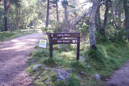
The walk starts from the road (Grid ref. NH915107) into the Holiday Park signed campsite and Lairig Ghru. Ignore the park entrance to your left and continue south. After a short while the path splits. Keep left following the signs for the Lairig Ghru. There now follows 7km of wonderful forest to clear before you start to climb.
Shortly after crossing the Cairngorm Club Footbridge you reach a junction. Turn right here following the signs for the Lairig Ghru once again. The path now slowly starts to climb and the views over the forest become amazing giving you the impression you are in the Canadian Rockies rather than the UK. This is a good place for a sheltered break as the forest starts to break shortly afterwards. From here continue out the forest towards the mouth of the Lairig Ghru, which is now in view. This is the deepest valley in the British Isles and on the approach there is no doubting that fact. The scale as you enter is breathtaking.
Once you leave the forest the slog seems to go on for ever but after an hour or so you enter the valley and cross the river Allt Druidh. From here leave the main track and head on the one to your right aiming south up the slopes of Coire Gorm (Grid ref. NH959037).Behind you can see the Chalamain Gap. A considerable ascent lies ahead as you climb to reach the plateau of Sron na Lairige. Once on top expect to be buffeted by the wind even on a good day as you make your way southwards.
The faint track takes a turn right and you head downhill slightly into a col (Grid ref. NH963002) before making the final climb towards the east gully of Braeriach with impressive views of Cairn Toul and the Angels Peak directly to the south. This spot can be very windy so it is best to stay back in safety even though the views can be tempting for an awesome photo near the edge! Here you start out for the final climb onto Braeriach summit where you take in the impressive views. Glenmore forest lies to the north with Ben Macdui to the west.
For the super fit who reach this point in under 5 hours, you have the choice of continuing around the edge taking in Cairn Toul and onto the Devil's Point where a path drops steeply down to the Main Larig Ghru path or simply re-trace your steps as I did; after all it's a long way back! Back at the start you can reflect on completing a superb summer route into the heart of the Cairngorm mountain range.
Maps 

| Ordnance Survey Explorer OL57 | Sheet Map | 1:25k | BUY |
| Anquet OS Explorer OL57 | Digital Map | 1:25k | BUY |
| Ordnance Survey Digital Map Subscription | |||
| Latest Ordnance Survey Discounts | |||
Other walks nearby
| Walk 1906 | Lochan Mor & Rothiemurchus Forest from Inverdruie | easy/mod | 3.6 miles |
| Walk 1505 | Craigellachie National Nature Reserve | easy/mod | 5.0 miles |
| Walk 1904 | Loch Morlich circular (near Aviemore) | easy | 4.0 miles |
| Walk 2412 | Craiggowrie & Creagan Gorm from Loch Morlich | mod/hard | 7.3 miles |
| Walk 2607 | Lairig Ghru & Chalamain Gap from Glenmore | mod/hard | 11.0 miles |
| Walk 3579 | Meall a'Bhuachaille & Ryvoan Bothy from Glenmore | moderate | 5.5 miles |
| Walk 3218 | Eag a' Chait gap Via Rothiemurchus Lodge from Glenmore | moderate | 8.2 miles |
| Walk 1020 | Glenmore to Linn of Dee via Lairig Ghru & Corrour | hard | 21.0 miles |
| Walk 1605 | Loch an Eilein & Rothiemurchus Forest from Loch Morlich | easy/mod | 10.0 miles |
| Walk 2421 | Braeriach via the Chalamain Gap | hard | 15.0 miles |
Recommended Books & eBooks
Skye's Cuillin Ridge Traverse
 This 2-volume set provides all the information required to complete the main ridge traverse on Skye's Black Cuillin. Strategy, gear, training, navigation and logistics are covered, and 10 classic scrambles are described. A lightweight second guidebook gives the scrambler detailed maps, topos and route description for the ridge traverse itself.
More information
Walking the Munros Vol 2 - Northern Highlands and the Cairngorms
 Guidebook to walking the northern Munros, covering the northern Highlands, the Cairngorms and the Isle of Skye. 70 routes are described, including those up Ben Macdui, Braeriach and Cairn Gorm. Routes range from 7 to 46km, requiring a fair level of fitness. The second of two guidebooks to walking Scotland's Munros: peaks higher than 3000ft.
More information
