Coldingham & Abbs Head
Scottish Borders Walk
County/Area - Scottish Borders
Author - Lou Johnson
Length - 7.2 miles / 11.7 km Ascent - 1100 feet / 333 metres
Time - 4 hours 40 minutes Grade - easy/mod
Maps 

| Ordnance Survey Explorer 346 | Sheet Map | 1:25k | BUY |
| Anquet OS Explorer 346 | Digital Map | 1:25k | BUY |
Walk Route Description
Click image to see photo description.
This Scottish Borders walk is full of scenic interest including pleasant countryside, a beautiful loch and a spectacular section of coast. The start is the parking area adjacent to the small harbour at St Abbs (grid ref. NT920672). After parking take the narrow lane and footpath to reach Seaview Terrace and continue into Creel Road.
Walk along Creel Road away from the sea and where the toad bends to the left continue straight ahead onto a track through a gate (grid ref. NT918671). You are now following the Creel Path which climbs gently to reach the B6438 (grid ref. NT909665). Bear left along this road using the pavement and continue into High Street and the centre of the attractive village of Coldingham. At the junction with the A1107 (grid ref. NT902659) turn right into School Road. After passing the primary school, on your right, turn right into West Loch Road (grid ref. NT899661).
This quiet road soon enters pleasant countryside and is followed for about 1.5 miles. You pass the entrance to Pilmuir Farm on your right and to reach the entrance to West Loch Farm. After 200 metres locate the stile and footpath sign on the right (grid ref. NT893680). Follow this path across three fields to reach a track (grid ref. NT895683). Turn right along the track to a gate. Turn left here and continue to the next gate where the track turns left across open farmland passing the remains of an iron-age settlement on your right.
Reaching the shore of Coldingham Loch, turn right just before a gate and continue over the field with the fence to your left. Ignore the first stile and continue to the second stile. Cross this and follow the coast path with the sea to your left. The onward route offers some wonderful coastal views. Continue on the path crossing stiles to reach the access road to St Abbs Head (grid ref. NT908689).
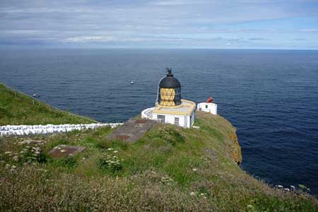
Turn left and follow the road which initially climbs steeply to reach the Nature Reserve and Lighthouse. To continue take the clear path southeast and then south to a gate. Continue along the coast path passing Horsecastle Bay and Burnmouth Harbour. A final ascent takes you on to the seaward flank of Bell Hill where the views are worth enjoying for a few minutes. Continue by descending on the coast path through small areas of woodland to reach the B6438. Turn left and continue down to the harbour and the start of the walk.
Other walks nearby
| Walk 3653 | St. Abb's Head from St. Abbs | easy | 4.2 miles |
| Walk 1894 | Burnhope Reservoir Circular | easy | 2.8 miles |
| Walk 3356 | Dunbar circular from John Muir Country Park | easy/mod | 8.0 miles |
| Walk 3242 | Holy Island - Lindisfarne Castle & Emmanuel Head | easy | 4.4 miles |
| Walk 3344 | Holy Island & Lindisfarne Castle Circular | easy | 4.3 miles |
| Walk 2677 | Circuit of Doddington Moor | easy | 3.8 miles |
| Walk 1314 | Great Hetha and Elsdon Burn from Hethpool | easy/mod | 4.0 miles |
| Walk 3644 | Blackhaggs Rigg & Great Hetha from Hethpool | moderate | 9.6 miles |
| Walk 3646 | Hethpool, Sutherland Bridge & Great Hetha | moderate | 6.0 miles |
| Walk 3739 | Elsdonburn & Trowupburn from Hethpool | moderate | 8.2 miles |
Recommended Books & eBooks
Walking in the Southern Uplands
 Guidebook to 44 varied day walks and over 100 summits in the Southern Uplands of Scotland, stretching south-west from Edinburgh to the English border, including the Galloway and Pentland Hills. Between 2 and 29km, there is something for all seasons and all abilities in remote and rugged hill country.
More information
The Borders Abbeys Way
 Guidebook to the Borders Abbeys Way, a 68 mile circuit in the Scottish Borders, taking in 4 of Britain's grandest ruined medieval abbeys. Beginning and ending in Tweedbank, the route, which is described over 6 stages, is as rich in history as it is in pastoral charm. Relatively flat, it is suitable for people with a moderate level of fitness.
More information
Messaging & Social Media
Message Walking Britain and follow the latest news.

Mountain Weather
Stay safe on the mountains with detailed weather forecasts - for iOS devices or for Android devices.