Elsdonburn & Trowupburn from Hethpool
Northumberland Walk
Nat Park - Northumberland
County/Area - Northumberland County
Author - Lou Johnson
Length - 8.2 miles / 13.3 km Ascent - 1800 feet / 545 metres
Time - 5 hours 50 minutes Grade - moderate
Walk Route Description
Click image to see photo description.
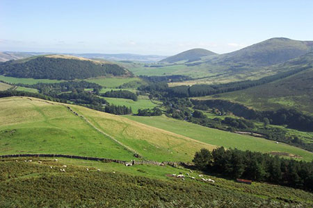
This glorious walk in the Northumberland National Park explores a beautiful area of grassy rounded hills south of the England Scotland border. The area sees few walkers with the route following paths and tracks across the undulating landscape. The area is also rich in Iron Age relics including hillforts and settlements.
The start is the small parking area just south of Hethpool (grid ref. NT894281). After parking, exit the car park and return along the lane passing the cottages on the left. Follow the road as it bends left and continue to the next bend (grid ref. NT894286). Turn left across the cattle grid and after a short distance turn right at a fingerpost signed to Ring Chesters. Follow the rising grassy path (the Hillforts Trail) which has regular way posts. Continue across a stile and stay on the marked path cross a second stile. The onward path follows the wall/fence on your left to pass through a small gate.
Continue on marked path through a partially felled plantation. The path soon turns left and descends to a stile. Cross the stile and head uphill to the hillfort of Ring Chesters (grid ref. NT867289). Maintain direction and descend to a track (grid ref. NT865286). Turn left and follow the track downhill. Cross ford and pass through a metal gate.
By the Border Ridge sign, turn right past Elsdonburn Farm (grid ref. NT874284). After 650 metres you reach a fork. Keep left and follow the clear track across the western flank of Ell's Knowe with a plantation on your right. Pass through a gate and head southwest aiming for the highest point. You soon reach a fence. Keep this on your left and complete the ascent to the summit of Madam Law. Descend alongside the fence to reach the col of Wideopen Head (grid ref. NT861265). Turn sharp left through a gate and join a grassy track. Just before a sheepfold (grid ref. NT871265) bear right to descend to Trowupburn (grid ref. NT876265).
Continue past the farm (on your right) to join a tarmac lane heading uphill. After 400 metres turn right onto a signed footpath (Hillforts Trail) up to Great Hetha. Follow the grassy track uphill with several way markers to reach the hill fort earthworks on top of Great Hetha. The view from the summit is outstanding. Continue following way markers downhill to reach the left-hand corner of a plantation. Turn right along the edge of the plantation and continue down to the private road. Turn left along the road back to the start.
Maps 

| Ordnance Survey Explorer OL16 | Sheet Map | 1:25k | BUY |
| Anquet OS Explorer OL16 | Digital Map | 1:25k | BUY |
| Ordnance Survey Digital Map Subscription | |||
| Latest Ordnance Survey Discounts | |||
Other walks nearby
| Walk 2299 | The Cheviot | moderate | 9.0 miles |
| Walk 1201 | Black Hag from Kirk Yetholm | moderate | 8.5 miles |
| Walk 1764 | The Cheviot from Langleeford | mod/hard | 8.2 miles |
| Walk 1765 | Comb Fell & Hedgehope Hill from Langleeford | mod/hard | 8.9 miles |
| Walk 1776 | The Cheviot & Auchope Cairn from Langleeford | mod/hard | 10.0 miles |
| Walk 2152 | Hartshope Linn (waterfall) from Langleeford | easy | 4.4 miles |
| Walk 2153 | Housey Crags from Langleeford | easy/mod | 2.0 miles |
| Walk 2677 | Circuit of Doddington Moor | easy | 3.8 miles |
| Walk 1894 | Burnhope Reservoir Circular | easy | 2.8 miles |
| Walk 3296 | Grubbit Law & Hownam Law from Morebattle | moderate | 7.0 miles |
Recommended Books & eBooks
Hadrian's Wall Path
 Hadrians Wall Path guidebook to walk the 84 mile National Trail. Described in both directions, the main description is west to east between Bowness-on-Solway and Wallsend, Newcastle, with extensions to Maryport and South Shields. With extensive historical information related to this World Heritage site and separate 1:25,000 OS map booklet included.
More information
Walking in Northumberland
 This guidebook contains detailed route descriptions for 36 day walks in Northumberland including the Cheviot Hills. The terrain varies from wild walks and craggy ascents to gentle riverside strolls. Each route ranges from 4 to 16 miles in length and there is the opportunity to link several walks together to create longer treks.
More information
