Portscatho & Porthmellin Head
Coastal Walk + Pub Walk + Countryside
Cornwall AONB Walk
Region - Cornwall AONB
County/Area - Cornwall
Author - Philip Halling
Length - 5.5 miles / 8.9 km Ascent - 650 feet / 197 metres
Time - 3 hours 20 minutes Grade - easy
Walk Route Description
Click image to see photo description.
Coastal walk from Portscatho to Porthmellin Head using the South West Coast Path. The outward route is easy to follow to the small community of Bohortha. Turning inland the walk follows lanes and bridleways back to the start. The Plume of Feathers by Portscatho harbour is ideal for those wishing to combine the walk with a pub visit.
The walk starts from Portscatho pay and display car park (grid ref. SW876357) which is signed from the main approach to the village. After parking walk towards the sea and turn right along the South West Coast Path (SWCP). Continue ahead to reach the harbour front. The SWCP passes in front of a row of cottages on your right with a good view across the harbour on your left. The view along the coast extends to Nare Head. At the end of the road continue ahead on the coast path.
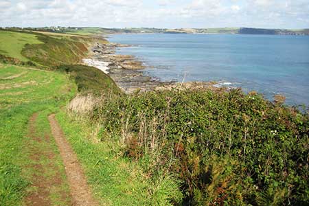
The route is easy to follow as you head south along a headland which terminates at St Anthony's Head (not visited on this walk). After 1.5 kilometres you reach Greeb Point where the next section of coast comes into view. Continue along the coast path above Towan Beach to Porthmellin Head. From here the path swings west above Porthbeor Beach. About halfway along the beach you reach a bench with adjacent fingerpost pointing inland. Turn right here and continue the short distance to a kissing gate and a lane (grid ref. SW862231).
Turn right along the lane and follow the lane as it bends right at the first junction. Stay on the lane for a further kilometre to descend past the car park for Towan Beach on your left. At the bottom of the hill, pass the path to Towan Beach on your right and after a few metres fork right onto a track initially between hedges. The bridleway crosses typical countryside of the area soon passing through the buildings at Rosteaugue. The bridleway leads into a narrow lane. Pass a caravan site on the right and take the next footpath on the right with adjacent fingerpost initially into a camping area. Continue ahead and at the end of the camping site bear half-left and continue down to the seafront in Portscatho. Turn left and retrace your steps back to the car park.
Maps 

| Ordnance Survey Explorer 105 | Sheet Map | 1:25k | BUY |
| Anquet OS Explorer 105 | Digital Map | 1:25k | BUY |
| Ordnance Survey Digital Map Subscription | |||
| Latest Ordnance Survey Discounts | |||
Other walks nearby
| Walk 2757 | St Anthony Head Circular | easy | 3.5 miles |
| Walk 2003 | Cowlands, Coombe & Roundwood Quay from Trelissick | easy/mod | 9.0 miles |
| Walk 1027 | Nare Head & Portloe | moderate | 7.0 miles |
| Walk 1033 | Dodman Point & Gorran Haven | mod/hard | 11.0 miles |
| Walk 2088 | Rosemullion Head & Mawnan | easy | 4.0 miles |
| Walk 2007 | Helford Passage & Frenchman's Creek | easy/mod | 7.0 miles |
| Walk 1783 | Gorran Haven & Dodman Point | easy/mod | 5.0 miles |
| Walk 2009 | Gillan & Nare Point from Porthallow | easy | 4.7 miles |
| Walk 1778 | Maenporth and Helford Passage Circular | easy/mod | 8.0 miles |
| Walk 2001 | Coverack & Lowland Point | easy/mod | 4.2 miles |
Recommended Books & eBooks
South West Coast Path Map Booklet - Minehead to St Ives
 Map of the northern section of the 630 mile (1014km) South West Coast Path National Trail. Covers the trail from Minehead to St Ives along the north Devon and Cornish coastline. This convenient and compact booklet of Ordnance Survey 1:25,000 maps shows the route, providing all of the mapping you need to walk the trail in either direction.
More information
Walking in Cornwall
 This guidebook includes routes to 40 day walks in Cornwall. From short, easy strolls to longer, wilder routes, there is plenty to appeal to both families and experienced walkers. The walks explore the interior and coasts, including walks through picturesque villages, old tin-mining areas and the Lizard and Land's End Peninsulas.
More information
